
Fai una donazione
Preparati per la tua prossima avventura:
In qualità di associato Amazon, questo sito riceve una commissione sugli acquisti idonei senza alcun costo aggiuntivo per te.
Mappa topografica Jharkhand
Clicca sulla mappa per visualizzare l'altitudine.
Fai una donazione
Preparati per la tua prossima avventura:
In qualità di associato Amazon, questo sito riceve una commissione sugli acquisti idonei senza alcun costo aggiuntivo per te.
A proposito di questa mappa
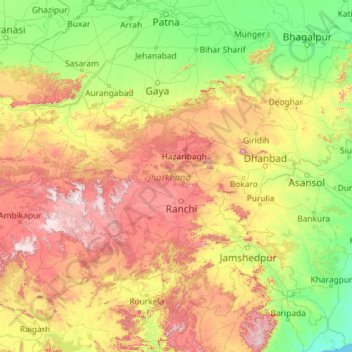
Nome: Mappa topografica Jharkhand, altitudine, rilievo.
Luogo: Jharkhand, India (21.97003 83.32811 25.34892 87.96283)
Altitudine media: 277 m
Altitudine minima: 0 m
Altitudine massima: 1.192 m
Fai una donazione
Preparati per la tua prossima avventura:
In qualità di associato Amazon, questo sito riceve una commissione sugli acquisti idonei senza alcun costo aggiuntivo per te.
Altre mappe topografiche
Clicca su una mappa per visualizzarne la topografia, l'altitudine e il rilievo.
Varanasi
India > Uttar Pradesh > Sadar
Varanasi is located at an elevation of 80.71 metres (264.8 ft) in the centre of the Ganges valley of North India, in the Eastern part of the state of Uttar Pradesh, along the left crescent-shaped bank of the Ganges, averaging between 15 metres (50 ft) and 21 metres (70 ft) above the river. The city is the…
Altitudine media: 77 m
Fai una donazione
Preparati per la tua prossima avventura:
In qualità di associato Amazon, questo sito riceve una commissione sugli acquisti idonei senza alcun costo aggiuntivo per te.
Nainital
India > Uttarakhand > Nainital
The city of Nainital covers a total area of 11.73 km2 (4.53 sq mi), and is located at 29°23′N 79°27′E / 29.38°N 79.45°E / 29.38; 79.45, at an average elevation of 2,084 metres (6,837 ft) above sea level. The slopes of the nearby mountains are most populated, with an elevation ranging from…
Altitudine media: 1.813 m
Mumbai
Mumbai lies at the mouth of the Ulhas River on the western coast of India, in the coastal region known as the Konkan. It sits on Salsette Island (Sashti Island), which it partially shares with the Thane district. Mumbai is bounded by the Arabian Sea to the west. Many parts of the city lie just above sea level,…
Altitudine media: 13 m
Fai una donazione
Preparati per la tua prossima avventura:
In qualità di associato Amazon, questo sito riceve una commissione sugli acquisti idonei senza alcun costo aggiuntivo per te.
Surat
India > Gujarat > Katargam Taluka > Surat
Surat is a port city situated on the banks of the Tapi river. Damming of the Tapi caused the original port facilities to close; the nearest port is now in the Magadalla and Hazira area of Surat Metropolitan Region.It has famous beach called 'Dumas Beach' located in Hazira. The city is located at 21°10′N…
Altitudine media: 11 m
Navi Mumbai
India > Maharashtra > Thane > Navi Mumbai
Navi Mumbai (Marathi pronunciation: , also known by its former name New Bombay), is a planned city off the west coast of the Indian state of Maharashtra in Konkan division. The city is divided into two parts, North Navi Mumbai and South Navi Mumbai, for the individual development of Panvel Mega City, which…
Altitudine media: 30 m
Fai una donazione
Preparati per la tua prossima avventura:
In qualità di associato Amazon, questo sito riceve una commissione sugli acquisti idonei senza alcun costo aggiuntivo per te.
Vadodara
India > Gujarat > Vadodara Rural Taluka
Vadodara is located at 22°18′N 73°11′E / 22.30°N 73.19°E / 22.30; 73.19 in western India at an elevation of 39 metres (128 ft). It is the tenth-largest city in India with an area of 400 square kilometres (150 sq mi) and a population of 3.5 million, according to the 2010–11 census. The city…
Altitudine media: 36 m
Fai una donazione
Preparati per la tua prossima avventura:
In qualità di associato Amazon, questo sito riceve una commissione sugli acquisti idonei senza alcun costo aggiuntivo per te.
Anini
India > Arunachal Pradesh > Anini Circle
The small settlement of Anini is located at an elevation of 1,968 metres (6,457 ft) above sea level. On the Aninese Plateau, the average elevation is 1,800 meters, but the average elevation of the town is 2,068 meters. According to Google Maps' terrain feature, Anini is around 1,600–1,800 meters above sea…
Altitudine media: 1.660 m
Dehradun
India > Uttarakhand > Dehradun
The city of Dehradun mainly lies in Doon Valley and is at a varying height from 410 m (1,350 ft) in Clement Town to above 700 m (2,300 ft) at Malsi which is 15 km (9.3 mi) from the city. However, the average elevation is 450 m (1,480 ft) above sea level. Malsi is the starting point of Lesser Himalayan Range…
Altitudine media: 904 m
Fai una donazione
Preparati per la tua prossima avventura:
In qualità di associato Amazon, questo sito riceve una commissione sugli acquisti idonei senza alcun costo aggiuntivo per te.
Fai una donazione
Preparati per la tua prossima avventura:
In qualità di associato Amazon, questo sito riceve una commissione sugli acquisti idonei senza alcun costo aggiuntivo per te.
Shimla
Shimla is on the south-western ranges of the Himalayas at 31°37′N 77°06′E / 31.61°N 77.10°E / 31.61; 77.10. It has an average altitude of 2,206 metres (7,238 ft) above mean sea level and extends along a ridge with seven spurs. The city stretches nearly 9.2 kilometres (5.7 mi) from east to west.
Altitudine media: 1.557 m
Fai una donazione
Preparati per la tua prossima avventura:
In qualità di associato Amazon, questo sito riceve una commissione sugli acquisti idonei senza alcun costo aggiuntivo per te.
Sudarshan Parbat
India > Uttarakhand > Bhatwari
Sudarshan Parbat is a mountain of the Garhwal Himalaya in Uttarakhand India.The elevation of Sudarshan Parbat is 6,529 metres (21,421 ft) and its prominence is 456 metres (1,496 ft). It is joint 87th highest located entirely within the Uttrakhand. Nanda Devi, is the highest mountain in this category. Sudarshan…
Altitudine media: 5.792 m
Fai una donazione
Preparati per la tua prossima avventura:
In qualità di associato Amazon, questo sito riceve una commissione sugli acquisti idonei senza alcun costo aggiuntivo per te.
Fai una donazione
Preparati per la tua prossima avventura:
In qualità di associato Amazon, questo sito riceve una commissione sugli acquisti idonei senza alcun costo aggiuntivo per te.
Fai una donazione
Preparati per la tua prossima avventura:
In qualità di associato Amazon, questo sito riceve una commissione sugli acquisti idonei senza alcun costo aggiuntivo per te.
Fai una donazione
Preparati per la tua prossima avventura:
In qualità di associato Amazon, questo sito riceve una commissione sugli acquisti idonei senza alcun costo aggiuntivo per te.
Maharashtra
Maharashtra is the third largest state by area in India. The Western Ghats better known as Sahyadri, are a hilly range running parallel to the coast, at an average elevation of 1,200 metres (4,000 ft). Kalsubai, a peak in the Sahyadris, near Nashik city is the highest elevated point in Maharashtra. To the west…
Altitudine media: 478 m
Bhubaneshwar
India > Odisha > Bhubaneswar (M.Corp.)
Bhubaneswar is in Khordha district of Odisha. It is in the eastern coastal plains, along the axis of the Eastern Ghats mountains. The city has an average altitude of 45 m (148 ft) above sea level. It lies southwest of the Mahanadi River that forms the northern boundary of Bhubaneswar metropolitan area, within…
Altitudine media: 30 m
Fai una donazione
Preparati per la tua prossima avventura:
In qualità di associato Amazon, questo sito riceve una commissione sugli acquisti idonei senza alcun costo aggiuntivo per te.
Vagamon
Vagamon, due to its elevation and climate, has a unique ecosystem, leading to the emergence of rich natural vegetation, plant species, shola forests etc. From the early 20th century plantation crops like tea, coffee started. Vagamon hills are home to less explored flora and fauna. A faunal diversity study…
Altitudine media: 866 m
Indore
India > Madhya Pradesh > Juni Indore Tahsil
Indore /ɪnˈdɔːr/ (listen) is the most populous and the largest city in the Indian state of Madhya Pradesh. It serves as the headquarters of both Indore District and Indore Division. It is also considered as an education hub of the state and has campuses of both the Indian Institute of Technology and the…
Altitudine media: 555 m
Lucknow
India > Uttar Pradesh > Lucknow
Lucknow stands at an elevation of approximately 123 metres (404 ft) above sea level. The city had an area of 402 km2 (155 square miles) until December 2019, when 88 villages were added to the municipal limits and the area increased to 631 km2 (244 square miles). Bounded on the east by Barabanki, on the west by…
Altitudine media: 120 m
Fai una donazione
Preparati per la tua prossima avventura:
In qualità di associato Amazon, questo sito riceve una commissione sugli acquisti idonei senza alcun costo aggiuntivo per te.
Kolkata
Spread roughly north–south along the east bank of the Hooghly River, Kolkata sits within the lower Ganges Delta of eastern India approximately 75 km (47 mi) west of the international border with Bangladesh; the city's elevation is 1.5–9 m (5–30 ft). Much of the city was originally a wetland that was…
Altitudine media: 5 m
Fai una donazione
Preparati per la tua prossima avventura:
In qualità di associato Amazon, questo sito riceve una commissione sugli acquisti idonei senza alcun costo aggiuntivo per te.
Fai una donazione
Preparati per la tua prossima avventura:
In qualità di associato Amazon, questo sito riceve una commissione sugli acquisti idonei senza alcun costo aggiuntivo per te.
Fai una donazione
Preparati per la tua prossima avventura:
In qualità di associato Amazon, questo sito riceve una commissione sugli acquisti idonei senza alcun costo aggiuntivo per te.
Khammam
India > Telangana > Khammam Urban mandal
Khammam is located at 17°15′N 80°09′E / 17.25°N 80.15°E / 17.25; 80.15. It has an average elevation of 108 metres (390 feet).
Altitudine media: 130 m
Fai una donazione
Preparati per la tua prossima avventura:
In qualità di associato Amazon, questo sito riceve una commissione sugli acquisti idonei senza alcun costo aggiuntivo per te.
Fai una donazione
Preparati per la tua prossima avventura:
In qualità di associato Amazon, questo sito riceve una commissione sugli acquisti idonei senza alcun costo aggiuntivo per te.
Chennai
Chennai is located on the south–eastern coast of India in the north–eastern part of Tamil Nadu on a flat coastal plain known as the Eastern Coastal Plains. Its average elevation is around 6.7 metres (22 ft), and its highest point is 60 m (200 ft). Chennai is 2,184 kilometres (1,357 mi) south of Delhi,…
Altitudine media: 7 m
Dahegam
India > Gujarat > Dehgam Taluka
Dahegam is located at 23°10′N 72°49′E / 23.17°N 72.82°E / 23.17; 72.82. It has an average elevation of 73 metres (239 feet).
Altitudine media: 76 m
Fai una donazione
Preparati per la tua prossima avventura:
In qualità di associato Amazon, questo sito riceve una commissione sugli acquisti idonei senza alcun costo aggiuntivo per te.
Navalagunda
India > Karnataka > Navalagunda taluku
Navalgund is located at 15°34′N 75°22′E / 15.57°N 75.37°E / 15.57; 75.37. It has an average elevation of 578 metres (1896 feet). It is situated 35 km from Hubli and is famous as the birth place of 'Jamkhanas', the floor covering woven using cotton ropes, a kind of flat & thin carpet. Locally…
Altitudine media: 579 m
Fai una donazione
Preparati per la tua prossima avventura:
In qualità di associato Amazon, questo sito riceve una commissione sugli acquisti idonei senza alcun costo aggiuntivo per te.
Panvel
India > Maharashtra > Panvel > Panvel
Matheran is a hill station and a municipal council in the Raigad district in the Indian state of Maharashtra. It is a hill station in Karjat Tahsil and is also the smallest hill station in India. It is located on the Western Ghats range at an elevation of around 800 m (2,625 feet) above sea level. It is…
Altitudine media: 75 m
Leh
Leh (/ˈlɛ/) (Ladakhi: གླེ) is the joint capital and largest city of Ladakh, a union territory of India. Leh, located in the Leh district, was also the historical capital of the Kingdom of Ladakh, the seat of which was in the Leh Palace, the former residence of the royal family of Ladakh, built in the…
Altitudine media: 4.294 m
Mussoorie
India > Uttarakhand > Dehradun
Mussoorie is at an average altitude of 2,005 metres (6,578 ft). To the northeast are the Himalayan snow ranges, and to the south, the Doon Valley and Shiwalik ranges. The second highest point is the original Lal Tibba in Landour, with a height of over 2,275 m (7,464 ft). Mussoorie is popularly known as The…
Altitudine media: 1.594 m
Fai una donazione
Preparati per la tua prossima avventura:
In qualità di associato Amazon, questo sito riceve una commissione sugli acquisti idonei senza alcun costo aggiuntivo per te.
Mysuru
India > Karnataka > Mysuru taluk
Mysore (/maɪˈsɔːr/ (listen)), officially Mysuru ([ˈmaɪˈsuːɾu] (listen)), is a city in the southern part of the state of Karnataka, India. Mysore city is geographically located between 12° 18′ 26″ north latitude and 76° 38′ 59″ east longitude. It is located at an altitude of 770 m (2,530 ft)…
Altitudine media: 727 m
Vrindavan
India > Uttar Pradesh > Mathura
Vrindavan is situated on the west bank of the Yamuna River, about 15 kilometres north of Mathura. "Maps, Weather, and Airports for Vrindavan, India". www.fallingrain.com. Retrieved 6 December 2019.</ref> It has an average elevation of 170 metres (557 feet).
Altitudine media: 172 m
Delhi
India > Delhi > Kotwali Tehsil
The topography of the medieval fort Purana Qila on the banks of the river Yamuna matches the literary description of the citadel Indraprastha in the Sanskrit epic Mahabharata; however, excavations in the area have revealed no signs of an ancient built environment. From the early 13th century until the mid-19th…
Altitudine media: 216 m
Fai una donazione
Preparati per la tua prossima avventura:
In qualità di associato Amazon, questo sito riceve una commissione sugli acquisti idonei senza alcun costo aggiuntivo per te.
Bhopal
India > Madhya Pradesh > Huzur Tahsil
Bhopal has an average elevation of 500 metres (1401 ft) and is located in the central part of India, just north of the upper limit of the Vindhya mountain ranges. Located on the Malwa plateau, it is higher than the north Indian plains and the land rises towards the Vindhya Range to the south. The city has…
Altitudine media: 498 m
Fai una donazione
Preparati per la tua prossima avventura:
In qualità di associato Amazon, questo sito riceve una commissione sugli acquisti idonei senza alcun costo aggiuntivo per te.
Fai una donazione
Preparati per la tua prossima avventura:
In qualità di associato Amazon, questo sito riceve una commissione sugli acquisti idonei senza alcun costo aggiuntivo per te.
Fai una donazione
Preparati per la tua prossima avventura:
In qualità di associato Amazon, questo sito riceve una commissione sugli acquisti idonei senza alcun costo aggiuntivo per te.