
Mappa topografica Vagamon
Clicca sulla mappa per visualizzare l'altitudine.
Vagamon
Vagamon, due to its elevation and climate, has a unique ecosystem, leading to the emergence of rich natural vegetation, plant species, shola forests etc. From the early 20th century plantation crops like tea, coffee started. Vagamon hills are home to less explored flora and fauna. A faunal diversity study conducted by Dr Pratheesh Mathew recorded 112 species of moths from 16 families under eight superfamilies and has become the prominent faunal diversity study in this area. The author has also recorded sightings of many species of insects, annelids, amphibians, lizards, snakes, birds and mammals. A wide variety of flowering and non-flowering plants, including rare Cycas species, has also been noted. The ongoing faunal and floral surveys are expected to shed light on the richness of biodiversity at this location. The flourishing tourism and related developments are predicted to have a negative impact on the flora and fauna of this region.
A proposito di questa mappa
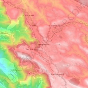
Nome: Mappa topografica Vagamon, altitudine, rilievo.
Luogo: Vagamon, Peerumade, Idukki, Kerala, 685503, India (9.64860 76.86686 9.72860 76.94686)
Altitudine media: 866 m
Altitudine minima: 179 m
Altitudine massima: 1.190 m
Altre mappe topografiche
Clicca su una mappa per visualizzarne la topografia, l'altitudine e il rilievo.
Periyar National Park Tiger Reserve
Periyar National Park lies in the middle of a mountainous area of the Cardamom Hills. In the north : The boundary commences from the point nearest to the Medaganam in the interstate boundary up to Vellimalai. and the east Thence the boundary follows the inter-state boundary from Vellimalai to Kallimalai Peak…
Altitudine media: 929 m