
Mappa topografica Haryana
Clicca sulla mappa per visualizzare l'altitudine.
Haryana
Haryana is a landlocked state in northern India. It is between 27°39' to 30°35' N latitude and between 74°28' and 77°36' E longitude. The total geographical area of the state is 4.42 m ha, which is 1.4% of the geographical area of the country. The altitude of Haryana varies between 700 and 3600 ft (200 metres to 1200 metres) above sea level. Haryana has only 4% (compared with national 21.85%) area under forests. Karoh Peak, a 1,467-metre (4,813 ft) tall mountain peak in the Sivalik Hills range of the greater Himalayas range located near Morni Hills area of Panchkula district, is highest point in Haryana. Most of the state sits atop the fertile Punjab Plain, a subsection of the Indo-Gangetic Plain. Haryana has 4 states and 2 union territories on its border – Punjab, Rajasthan, Uttar Pradesh, Himachal Pradesh, Delhi, and Chandigarh.
A proposito di questa mappa
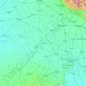
Nome: Mappa topografica Haryana, altitudine, rilievo.
Luogo: Haryana, India (27.65263 74.47351 30.92877 77.60214)
Altitudine media: 281 m
Altitudine minima: 169 m
Altitudine massima: 3.601 m
Altre mappe topografiche
Clicca su una mappa per visualizzarne la topografia, l'altitudine e il rilievo.
Surat
India > Gujarat > Katargam Taluka > Surat
Surat is a port city situated on the banks of the Tapi river. Damming of the Tapi caused the original port facilities to close; the nearest port is now in the Magadalla and Hazira area of Surat Metropolitan Region.It has famous beach called 'Dumas Beach' located in Hazira. The city is located at 21°10′N…
Altitudine media: 11 m
Vadodara
India > Gujarat > Vadodara Rural Taluka
Vadodara is located at 22°18′N 73°11′E / 22.30°N 73.19°E / 22.30; 73.19 in western India at an elevation of 39 metres (128 ft). It is the tenth-largest city in India with an area of 400 square kilometres (150 sq mi) and a population of 3.5 million, according to the 2010–11 census. The city…
Altitudine media: 36 m
Maharashtra
Maharashtra is the third largest state by area in India. The Western Ghats better known as Sahyadri, are a hilly range running parallel to the coast, at an average elevation of 1,200 metres (4,000 ft). Kalsubai, a peak in the Sahyadris, near Nashik city is the highest elevated point in Maharashtra. To the west…
Altitudine media: 478 m
Guwahati
Professor Abani Kumar Bhagawati of Gauhati University stated that since before there were sufficient wetlands to absorb rainwater and channels to carry excess water to the Brahmaputra, the city did not experience floods. However, human interference has disrupted the natural topography, leading to the current…
Altitudine media: 113 m
Bilimora
India > Gujarat > Gandevi Taluka
Bilimora is located at 20°45′N 72°57′E / 20.75°N 72.95°E / 20.75; 72.95. It has an average elevation of 4 metres (13 ft). Bilimora is the second largest city in the Navsari district after Navsari city. The city is supposed to have been surrounded by three rivers: Ambika from the north, Kaveri…
Altitudine media: 11 m
Thiruvananthapuram
India > Kerala > Thiruvananthapuram
Thiruvananthapuram is built on seven hills by the seashore and is at 8°30′N 76°54′E / 8.5°N 76.9°E / 8.5; 76.9 on the west coast, near the southern tip of mainland India. The city is on the west coast of India and is bounded by the Laccadive Sea to its west and the Western Ghats to its east.…
Altitudine media: 33 m
Kanpur
India > Uttar Pradesh > Kanpur
Situated in the flat Indo-Gangetic Plains, Kanpur has an average elevation of 318 metres (1,043 ft) above sea level. The Ganga flows by the city and several ghats are located on its banks, notably the Sati Chaura Ghat and Sarsaiya Ghat. The Brahmavart Ghat located at Bithoor (25 km northwards) is another ghat…
Altitudine media: 124 m
Rajkot
India > Gujarat > Rajkot East Taluka
Rajkot is located at 22°18′N 70°47′E / 22.3°N 70.78°E / 22.3; 70.78. It has an average elevation of 128 metres (420 ft). The city is located on the bank of Aji River and Nyari River which remains dry except the monsoon months of July to September. The city is spread in the area of 170.00 km².
Altitudine media: 141 m
Chengalpattu
India > Tamil Nadu > Chengalpattu
Chengalpattu is located at 12°42′N 79°59′E / 12.7°N 79.98°E / 12.7; 79.98. It has an average elevation of 36 metres (118 ft). Lake Kolavai is the largest located in Chengalpattu.
Altitudine media: 48 m
Sohra (Cherrapunji)
India > Meghalaya > Shella Bholaganj
It has an average elevation of 1,430 metres (4,690 ft) and sits on a plateau in the southern part of the Khasi Hills, facing the plains of Bangladesh. The plateau rises 660 meters above the surrounding valleys.
Altitudine media: 1.169 m
Madikeri
India > Karnataka > Madikeri taluku
Madikeri features a tropical highland climate as it has an elevation of 1,170 m (3,840 ft). Madikeri is located at 12°25′N 75°44′E / 12.42°N 75.73°E / 12.42; 75.73. Madikeri lies in the Western Ghats and is a popular hill station. The nearest cities are Hassan to the north, Mangaluru to the…
Altitudine media: 1.054 m
Mumbai
Mumbai lies at the mouth of the Ulhas River on the western coast of India, in the coastal region known as the Konkan. It sits on Salsette Island (Sashti Island), which it partially shares with the Thane district. Mumbai is bounded by the Arabian Sea to the west. Many parts of the city lie just above sea level,…
Altitudine media: 13 m
Handwara
India > Jammu and Kashmir > Handwara tehsil
Handwara is located at 34°24′N 74°17′E / 34.40°N 74.28°E / 34.40; 74.28 at an average elevation of 1,582 metres (5,190 feet) above sea level.
Altitudine media: 1.638 m
Hastinapur
India > Uttar Pradesh > Mawana
Present-day Hastinapur is a town in the Doab region of Uttar Pradesh in India, about 37 kilometres (23 mi) from Meerut and nearly 96 km (60 mi) north-east of Delhi on National Highway 34. It is a small township re-established by Jawaharlal Nehru on February 6, 1949, located at 29°10′N 78°01′E /…
Altitudine media: 226 m
Tirunelveli
India > Tamil Nadu > Palayamkottai
Tirunelveli is located at 8°43′41.82″N 77°41′43.94″E / 8.7282833°N 77.6955389°E / 8.7282833; 77.6955389, and its average elevation is 47 metres (154 ft). It is located at the southernmost tip of the Deccan plateau. The Tamirabarani River divides the city into the Tirunelveli quarter and…
Altitudine media: 34 m
Gorakhpur
India > Uttar Pradesh > Gorakhpur
Gorakhpur city is located in the north-easterrn part of Uttar Pradesh, India, within the Indo-Gangetic Plain. The city's geographical coordinates are 26.7663° N latitude and 83.3689° E longitude, with an altitude of 69 metres (229 feet) above sea level. Gorakhpur is situated about 100 km from the Nepal…
Altitudine media: 79 m
Kargil
India > Ladakh > Kargil tehsil
Kargil has an average elevation of 2,676 metres (8,780 feet), and is situated along the banks of the Suru River (Indus). The town of Kargil is located 205 km (127 mi) from Srinagar, facing the Northern Areas across the LOC. Like other areas in the Himalayas, Kargil has a temperate climate. Summers are hot with…
Altitudine media: 3.262 m
Patna
India > Bihar > Patna Rural
Patna is on the southern bank of the river Ganges. The total area of Patna is 250 km2 (97 sq mi). Of this, the municipal area constitutes 109.218 km2 (42.169 sq mi). The suburban area covers 140.782 km2 (54.356 sq mi). It has an average elevation of 53 m (174 ft). A characteristic feature of the geography of…
Altitudine media: 51 m
Ujjain
India > Madhya Pradesh > Ujjain NagarTahsil
Ujjain is located in the west-central part of India, and is north of the upper limit of the Vindhya mountain ranges. Located on the Malwa plateau, it is higher than the north Indian plains and the land rises towards the Vindhya Range to the south. Ujjain's co-ordinates are 23°10′N 75°46′E /…
Altitudine media: 501 m
Dehradun
India > Uttarakhand > Dehradun
The city of Dehradun mainly lies in Doon Valley and is at a varying height from 410 m (1,350 ft) in Clement Town to above 700 m (2,300 ft) at Malsi which is 15 km (9.3 mi) from the city. However, the average elevation is 450 m (1,480 ft) above sea level. Malsi is the starting point of Lesser Himalayan Range…
Altitudine media: 904 m
Rajsamand
India > Rajasthan > Rajsamand Tehsil
Rajsamand is located at 25°04′N 73°53′E / 25.07°N 73.88°E / 25.07; 73.88. It has an average elevation of 547 metres (1794 ft).
Altitudine media: 552 m
Yamuna River
The source of Yamuna lies in the Yamunotri Glacier at an elevation of 6,387 metres (20,955 ft), on the southwestern slopes of Banderpooch peaks, which lie in the Mussoorie range of the Lower Himalayas, north of Haridwar in Uttarkashi district, Uttarakhand. Yamunotri temple, a shrine dedicated to the goddess…
Altitudine media: 206 m
Mettupalayam
India > Tamil Nadu > Mettupalayam
Mettupalayam is located at 11°18′00″N 76°57′00″E / 11.3000°N 76.9500°E / 11.3000; 76.9500. It has an average elevation of 314 metres (1033 feet). Mettupalayam is situated on the bank of Bhavani River at the foot of the Nilgiri mountains.
Altitudine media: 321 m
Uluberia
India > West Bengal > Uluberia - I
Uluberia is located at 22°28′N 88°07′E / 22.47°N 88.11°E / 22.47; 88.11. It has an average elevation of 1 m (3.3 ft). It is situated on the banks of the river Hooghly. The main road passing through the heart of the city is Orissa trunk road and is also well connected by National Highway 16.…
Altitudine media: 5 m