
Mappa topografica Kargil
Clicca sulla mappa per visualizzare l'altitudine.
Kargil
Kargil has an average elevation of 2,676 metres (8,780 feet), and is situated along the banks of the Suru River (Indus). The town of Kargil is located 205 km (127 mi) from Srinagar, facing the Northern Areas across the LOC. Like other areas in the Himalayas, Kargil has a temperate climate. Summers are hot with cool nights, while winters are long and chilly with temperatures often dropping below −20 °C (−4 °F).
A proposito di questa mappa
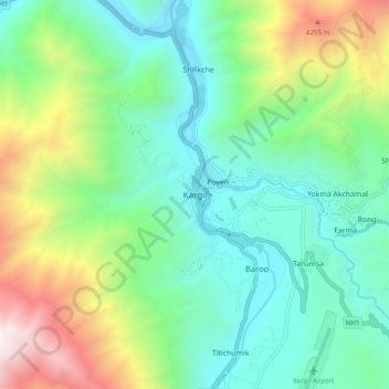
Nome: Mappa topografica Kargil, altitudine, rilievo.
Luogo: Kargil, Kargil Tehsil, Kargil district, Ladakh, 194103, India (34.51930 76.08558 34.59930 76.16558)
Altitudine media: 3.262 m
Altitudine minima: 2.613 m
Altitudine massima: 4.847 m