Geolocalizza

Mappa topografica Lucknow

Clicca sulla mappa per visualizzare l'altitudine.

Lucknow

The city stands at an elevation of approximately 123 metres (404 ft) above sea level. Lucknow city had an area of 402 km2 (155 square miles) till December 2019, when 88 villages were added to the municipal limits and the area increased to 631 km2 (244 square miles). Bounded on the east by Barabanki, on the west by Unnao, on the south by Raebareli and in the north by Sitapur and Hardoi, Lucknow sits on the northwestern shore of the Gomti River. As of 2008, there were 110 wards in the city. Morphologically, three clear demarcations exist: The Central business district, which is a fully built up area, comprises Hazratganj, Aminabad and Chowk. A middle zone surrounds the inner zone with cement houses while the outer zone consists of slums.

Wikipedia (CC-BY-SA 3.0)

👉 Easily get elevation data in JSON, GeoTIFF and KML formats using Elevation API
Grazie per il supporto a questo sito ❤️
Fai una donazione

Preparati per la tua prossima avventura:

In qualità di associato Amazon, questo sito riceve una commissione sugli acquisti idonei senza alcun costo aggiuntivo per te.

A proposito di questa mappa

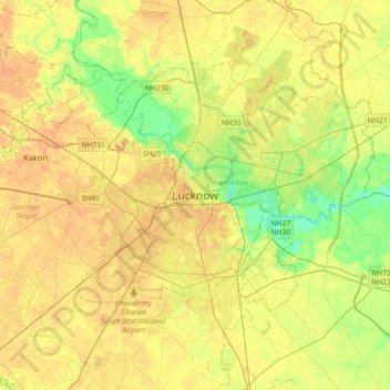
Nome: Mappa topografica Lucknow, altitudine, rilievo.

Luogo: Lucknow, Uttar Pradesh, 226027, India (26.67810 80.77460 26.99810 81.09460)

Altitudine media: 120 m

Altitudine minima: 103 m

Altitudine massima: 131 m

Altre mappe topografiche

Clicca su una mappa per visualizzarne la topografia, l'altitudine e il rilievo.

Kukrail

India > Uttar Pradesh > Lucknow > Lucknow

Altitudine media: 120 m

Residency

India > Uttar Pradesh > Lucknow > Lucknow

Altitudine media: 119 m

Mayura Park

India > Uttar Pradesh > Lucknow > Lucknow

Altitudine media: 119 m

Residency

India > Uttar Pradesh > Lucknow > Lucknow

Altitudine media: 119 m

Awadh Kunj Park

India > Uttar Pradesh > Lucknow > Lucknow

Altitudine media: 118 m

Preparati per la tua prossima avventura:

🧤Abbigliamento termico - Protezione dal freddo
🍖Cibo Liofilizzato - Pasti leggeri e nutrienti pronti in pochi minuti con acqua calda
🚲Computer per Bici - Dispositivi GPS per MTB con mappe dei sentieri e pendenze
🧴Creme Anti-Sfregamento - Per prevenire irritazioni cutanee durante lunghe marce
📻Walkie Talkie - Comunicazione radio affidabile dove non c'è campo cellulare

In qualità di associato Amazon, questo sito riceve una commissione sugli acquisti idonei senza alcun costo aggiuntivo per te.