
Mappa topografica St Albans
Mappa interattiva
Clicca sulla mappa per visualizzare l'altitudine.
A proposito di questa mappa
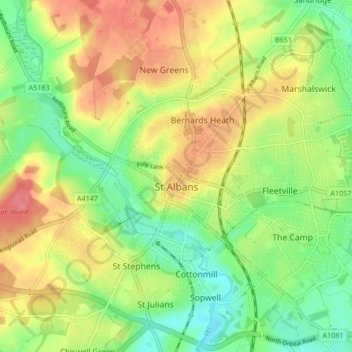
Nome: Mappa topografica St Albans, altitudine, rilievo.
Luogo: St Albans, Hertfordshire, England, United Kingdom (51.72913 -0.37529 51.78007 -0.29102)
Altitudine media: 103 m
Altitudine minima: 69 m
Altitudine massima: 141 m
The borough consisted of the ancient parish of St Albans (also known as the Abbey parish) and parts of the parishes of St Michael and St Peter. The borough was reformed by the Municipal Corporations Act 1835 to become a municipal borough, and the boundary was adjusted to additionally include part of the parish of St Stephen. On 28 August 1877 the borough gained city status, following the elevation of St Albans Abbey to become a cathedral. The boundary was also adjusted in 1877 to include part of the parish of Sandridge.
Altre mappe topografiche
Clicca su una mappa per visualizzarne la topografia, l'altitudine e il rilievo.
Baldock
United Kingdom > England > Hertfordshire > North Hertfordshire
Baldock, North Hertfordshire, Hertfordshire, England, SG7 6AS, United Kingdom
Altitudine media: 90 m
Hatfield
United Kingdom > England > Hertfordshire > Welwyn Hatfield
Hatfield, Welwyn Hatfield, Hertfordshire, England, United Kingdom
Altitudine media: 90 m
Hammond Street
United Kingdom > England > Hertfordshire > Broxbourne
Hammond Street, Broxbourne, Hertfordshire, England, EN7 6WH, United Kingdom
Altitudine media: 83 m
Verulamium Lake
United Kingdom > England > Hertfordshire > St Albans
Verulamium Lake, St Stephens, St Albans, Hertfordshire, England, United Kingdom
Altitudine media: 102 m
Tyttenhanger
United Kingdom > England > Hertfordshire > St Albans > Colney Heath
Tyttenhanger, Colney Heath, St Albans, Hertfordshire, England, AL4 0RN, United Kingdom
Altitudine media: 83 m
Hertford Heath
United Kingdom > England > Hertfordshire > East Hertfordshire
Hertford Heath, East Hertfordshire, Hertfordshire, England, United Kingdom
Altitudine media: 74 m
Ware
United Kingdom > England > Hertfordshire > East Hertfordshire
Ware, East Hertfordshire, Hertfordshire, England, United Kingdom
Altitudine media: 55 m
Tring
United Kingdom > England > Hertfordshire > Dacorum
Tring, Dacorum, Hertfordshire, England, United Kingdom
Altitudine media: 168 m
Stevenage
United Kingdom > England > Hertfordshire
Stevenage, Hertfordshire, England, United Kingdom
Altitudine media: 108 m
Stanstead Abbotts
United Kingdom > England > Hertfordshire > East Hertfordshire
Stanstead Abbotts, East Hertfordshire, Hertfordshire, England, SG12 8HU, United Kingdom
Altitudine media: 48 m
Letchworth
United Kingdom > England > Hertfordshire
Letchworth, Hertfordshire, England, United Kingdom
Altitudine media: 81 m
Bishop's Stortford
United Kingdom > England > Hertfordshire > East Hertfordshire
Bishop's Stortford, East Hertfordshire, Hertfordshire, England, United Kingdom
Altitudine media: 83 m
Norton
United Kingdom > England > Hertfordshire > Letchworth
Norton, Letchworth, Hertfordshire, England, SG6 1AG, United Kingdom
Altitudine media: 75 m
Middlesex
United Kingdom > England > Hertfordshire
Middlesex, Hertfordshire, Greater London, England, United Kingdom
Altitudine media: 46 m
Bovingdon
United Kingdom > England > Hertfordshire > Bovingdon
Bovingdon, Hertfordshire, East of England, England, HP3 0FA, United Kingdom
Altitudine media: 150 m
Bushey Heath
United Kingdom > England > Hertfordshire > Hertsmere > Bushey Heath
Bushey Heath, Hertsmere, Hertfordshire, East of England, England, WD23 1SH, United Kingdom
Altitudine media: 110 m
Royston
United Kingdom > England > Hertfordshire > North Hertfordshire
Royston, North Hertfordshire, Hertfordshire, England, United Kingdom
Altitudine media: 78 m
St Albans
United Kingdom > England > Hertfordshire > St Albans
St Albans, Hertfordshire, East of England, England, United Kingdom
Altitudine media: 107 m
Barkway
United Kingdom > England > Hertfordshire > North Hertfordshire
Barkway, North Hertfordshire, Hertfordshire, England, United Kingdom
Altitudine media: 119 m
Watford
United Kingdom > England > Hertfordshire
Watford, Hertfordshire, England, United Kingdom
Altitudine media: 77 m
Letchworth
United Kingdom > England > Hertfordshire > North Hertfordshire > Letchworth
Letchworth, North Hertfordshire, Hertfordshire, East of England, England, SG6 3BF, United Kingdom
Altitudine media: 80 m