
Mappa topografica Letchworth
Mappa interattiva
Clicca sulla mappa per visualizzare l'altitudine.
A proposito di questa mappa
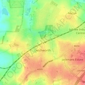
Nome: Mappa topografica Letchworth, altitudine, rilievo.
Luogo: Letchworth, Hertfordshire, England, United Kingdom (51.95965 -0.25510 51.99937 -0.19579)
Altitudine media: 81 m
Altitudine minima: 47 m
Altitudine massima: 112 m
Altre mappe topografiche
Clicca su una mappa per visualizzarne la topografia, l'altitudine e il rilievo.
Baldock
United Kingdom > England > Hertfordshire > North Hertfordshire
Baldock, North Hertfordshire, Hertfordshire, England, SG7 6AS, United Kingdom
Altitudine media: 90 m
Hatfield
United Kingdom > England > Hertfordshire > Welwyn Hatfield
Hatfield, Welwyn Hatfield, Hertfordshire, England, United Kingdom
Altitudine media: 90 m
Hammond Street
United Kingdom > England > Hertfordshire > Broxbourne
Hammond Street, Broxbourne, Hertfordshire, England, EN7 6WH, United Kingdom
Altitudine media: 83 m
Verulamium Lake
United Kingdom > England > Hertfordshire > St Albans
Verulamium Lake, St Stephens, St Albans, Hertfordshire, England, United Kingdom
Altitudine media: 102 m
Tyttenhanger
United Kingdom > England > Hertfordshire > St Albans > Colney Heath
Tyttenhanger, Colney Heath, St Albans, Hertfordshire, England, AL4 0RN, United Kingdom
Altitudine media: 83 m
Hertford Heath
United Kingdom > England > Hertfordshire > East Hertfordshire
Hertford Heath, East Hertfordshire, Hertfordshire, England, United Kingdom
Altitudine media: 74 m
St Albans
United Kingdom > England > Hertfordshire
St Albans, Hertfordshire, England, United Kingdom
Altitudine media: 103 m
Ware
United Kingdom > England > Hertfordshire > East Hertfordshire
Ware, East Hertfordshire, Hertfordshire, England, United Kingdom
Altitudine media: 55 m
Tring
United Kingdom > England > Hertfordshire > Dacorum
Tring, Dacorum, Hertfordshire, England, United Kingdom
Altitudine media: 168 m
Stevenage
United Kingdom > England > Hertfordshire
Stevenage, Hertfordshire, England, United Kingdom
Altitudine media: 108 m
Stanstead Abbotts
United Kingdom > England > Hertfordshire > East Hertfordshire
Stanstead Abbotts, East Hertfordshire, Hertfordshire, England, SG12 8HU, United Kingdom
Altitudine media: 48 m
Bishop's Stortford
United Kingdom > England > Hertfordshire > East Hertfordshire
Bishop's Stortford, East Hertfordshire, Hertfordshire, England, United Kingdom
Altitudine media: 83 m
Norton
United Kingdom > England > Hertfordshire > Letchworth
Norton, Letchworth, Hertfordshire, England, SG6 1AG, United Kingdom
Altitudine media: 75 m
Middlesex
United Kingdom > England > Hertfordshire
Middlesex, Hertfordshire, Greater London, England, United Kingdom
Altitudine media: 46 m
Bovingdon
United Kingdom > England > Hertfordshire > Bovingdon
Bovingdon, Hertfordshire, East of England, England, HP3 0FA, United Kingdom
Altitudine media: 150 m
Bushey Heath
United Kingdom > England > Hertfordshire > Hertsmere > Bushey Heath
Bushey Heath, Hertsmere, Hertfordshire, East of England, England, WD23 1SH, United Kingdom
Altitudine media: 110 m
Royston
United Kingdom > England > Hertfordshire > North Hertfordshire
Royston, North Hertfordshire, Hertfordshire, England, United Kingdom
Altitudine media: 78 m
St Albans
United Kingdom > England > Hertfordshire > St Albans
St Albans, Hertfordshire, East of England, England, United Kingdom
Altitudine media: 107 m
Barkway
United Kingdom > England > Hertfordshire > North Hertfordshire
Barkway, North Hertfordshire, Hertfordshire, England, United Kingdom
Altitudine media: 119 m
Watford
United Kingdom > England > Hertfordshire
Watford, Hertfordshire, England, United Kingdom
Altitudine media: 77 m
Letchworth
United Kingdom > England > Hertfordshire > North Hertfordshire > Letchworth
Letchworth, North Hertfordshire, Hertfordshire, East of England, England, SG6 3BF, United Kingdom
Altitudine media: 80 m