
Mappa topografica Baldock
Mappa interattiva
Clicca sulla mappa per visualizzare l'altitudine.
A proposito di questa mappa
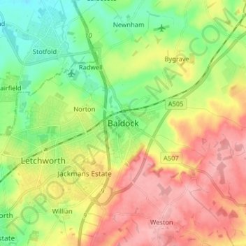
Nome: Mappa topografica Baldock, altitudine, rilievo.
Altitudine media: 90 m
Altitudine minima: 38 m
Altitudine massima: 152 m
Altre mappe topografiche
Clicca su una mappa per visualizzarne la topografia, l'altitudine e il rilievo.
Royston
United Kingdom > England > Hertfordshire > North Hertfordshire
Royston, North Hertfordshire, Hertfordshire, England, United Kingdom
Altitudine media: 78 m
Barkway
United Kingdom > England > Hertfordshire > North Hertfordshire
Barkway, North Hertfordshire, Hertfordshire, England, United Kingdom
Altitudine media: 119 m
Letchworth
United Kingdom > England > Hertfordshire > North Hertfordshire > Letchworth
Letchworth, North Hertfordshire, Hertfordshire, East of England, England, SG6 3BF, United Kingdom
Altitudine media: 80 m