
Fai una donazione
Preparati per la tua prossima avventura:
In qualità di associato Amazon, questo sito riceve una commissione sugli acquisti idonei senza alcun costo aggiuntivo per te.
Mappa topografica Shawell
Clicca sulla mappa per visualizzare l'altitudine.
Fai una donazione
Preparati per la tua prossima avventura:
In qualità di associato Amazon, questo sito riceve una commissione sugli acquisti idonei senza alcun costo aggiuntivo per te.
A proposito di questa mappa
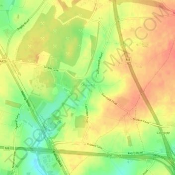
Nome: Mappa topografica Shawell, altitudine, rilievo.
Luogo: Shawell, Leicestershire, England, United Kingdom (52.40187 -1.22362 52.43262 -1.17308)
Altitudine media: 127 m
Altitudine minima: 98 m
Altitudine massima: 145 m
Fai una donazione
Preparati per la tua prossima avventura:
In qualità di associato Amazon, questo sito riceve una commissione sugli acquisti idonei senza alcun costo aggiuntivo per te.
Altre mappe topografiche
Clicca su una mappa per visualizzarne la topografia, l'altitudine e il rilievo.
Stoke Golding
United Kingdom > England > Leicestershire > Hinckley and Bosworth
Altitudine media: 102 m
Fai una donazione
Preparati per la tua prossima avventura:
In qualità di associato Amazon, questo sito riceve una commissione sugli acquisti idonei senza alcun costo aggiuntivo per te.
Fai una donazione
Preparati per la tua prossima avventura:
In qualità di associato Amazon, questo sito riceve una commissione sugli acquisti idonei senza alcun costo aggiuntivo per te.
Fai una donazione
Preparati per la tua prossima avventura:
In qualità di associato Amazon, questo sito riceve una commissione sugli acquisti idonei senza alcun costo aggiuntivo per te.
Coalville
United Kingdom > England > Leicestershire > North West Leicestershire
Altitudine media: 149 m
Fai una donazione
Preparati per la tua prossima avventura:
In qualità di associato Amazon, questo sito riceve una commissione sugli acquisti idonei senza alcun costo aggiuntivo per te.
Fai una donazione
Preparati per la tua prossima avventura:
In qualità di associato Amazon, questo sito riceve una commissione sugli acquisti idonei senza alcun costo aggiuntivo per te.
Isley Walton
United Kingdom > England > Leicestershire > North West Leicestershire
Altitudine media: 76 m
Fai una donazione
Preparati per la tua prossima avventura:
In qualità di associato Amazon, questo sito riceve una commissione sugli acquisti idonei senza alcun costo aggiuntivo per te.
Markfield
United Kingdom > England > Leicestershire > Hinckley and Bosworth > Markfield
Altitudine media: 174 m
Castle Donington
United Kingdom > England > Leicestershire > North West Leicestershire > Hemington
Altitudine media: 56 m
Fai una donazione
Preparati per la tua prossima avventura:
In qualità di associato Amazon, questo sito riceve una commissione sugli acquisti idonei senza alcun costo aggiuntivo per te.
Bottesford
United Kingdom > England > Leicestershire > Melton
Bottesford's many listed buildings include the grade I listed 13th-century Church of St Mary the Virgin. There are two scheduled monuments within the village – Fleming's Bridge and the stone cross in the Market Place. The stocks and whipping post are Grade II listed. One of the Grade II listed buildings,…
Altitudine media: 39 m
Fai una donazione
Preparati per la tua prossima avventura:
In qualità di associato Amazon, questo sito riceve una commissione sugli acquisti idonei senza alcun costo aggiuntivo per te.
Ratcliffe Culey
United Kingdom > England > Leicestershire > Hinckley and Bosworth
Altitudine media: 77 m
Fai una donazione
Preparati per la tua prossima avventura:
In qualità di associato Amazon, questo sito riceve una commissione sugli acquisti idonei senza alcun costo aggiuntivo per te.
South Croxton
United Kingdom > England > Leicestershire > Charnwood > South Croxton
The highest point is the church, at 120 m above mean sea level. The lowest altitude is 85 m by the Queniborough Brook.
Altitudine media: 108 m
Thringstone
United Kingdom > England > Leicestershire > North West Leicestershire
Altitudine media: 126 m
Groby
United Kingdom > England > Leicestershire > Hinckley and Bosworth > Groby
Altitudine media: 107 m
Fai una donazione
Preparati per la tua prossima avventura:
In qualità di associato Amazon, questo sito riceve una commissione sugli acquisti idonei senza alcun costo aggiuntivo per te.
Swannington
United Kingdom > England > Leicestershire > North West Leicestershire > Coalville
Altitudine media: 132 m
Ashby-de-la-Zouch
United Kingdom > England > Leicestershire > North West Leicestershire
Altitudine media: 132 m
Queniborough
United Kingdom > England > Leicestershire > Charnwood > Queniborough
Altitudine media: 75 m
Fai una donazione
Preparati per la tua prossima avventura:
In qualità di associato Amazon, questo sito riceve una commissione sugli acquisti idonei senza alcun costo aggiuntivo per te.
Fai una donazione
Preparati per la tua prossima avventura:
In qualità di associato Amazon, questo sito riceve una commissione sugli acquisti idonei senza alcun costo aggiuntivo per te.
Illston on the Hill
United Kingdom > England > Leicestershire > Harborough > Illston on the Hill
Altitudine media: 158 m
Fai una donazione
Preparati per la tua prossima avventura:
In qualità di associato Amazon, questo sito riceve una commissione sugli acquisti idonei senza alcun costo aggiuntivo per te.
Great Glen
United Kingdom > England > Leicestershire > Harborough > Great Glen
Altitudine media: 115 m
Fai una donazione
Preparati per la tua prossima avventura:
In qualità di associato Amazon, questo sito riceve una commissione sugli acquisti idonei senza alcun costo aggiuntivo per te.
Stretton Baskerville
United Kingdom > England > Leicestershire > Hinckley and Bosworth
Altitudine media: 111 m
Fai una donazione
Preparati per la tua prossima avventura:
In qualità di associato Amazon, questo sito riceve una commissione sugli acquisti idonei senza alcun costo aggiuntivo per te.
Leicester Forest East
United Kingdom > England > Leicestershire > Leicester Forest East
Altitudine media: 96 m
Breedon on the Hill
United Kingdom > England > Leicestershire > North West Leicestershire
Altitudine media: 84 m
Fai una donazione
Preparati per la tua prossima avventura:
In qualità di associato Amazon, questo sito riceve una commissione sugli acquisti idonei senza alcun costo aggiuntivo per te.
South Kilworth
United Kingdom > England > Leicestershire > Harborough > South Kilworth
Altitudine media: 134 m
Leicestershire
United Kingdom > England > Leicestershire
A large part of the north-west of the county, around Coalville, forms part of the new National Forest area extending into Derbyshire and Staffordshire. The highest point of the county is Bardon Hill at 278 m (912 ft), which is also a Marilyn; with other hilly/upland areas of c. 150–200 metres (490–660 ft)…
Altitudine media: 98 m
Fai una donazione
Preparati per la tua prossima avventura:
In qualità di associato Amazon, questo sito riceve una commissione sugli acquisti idonei senza alcun costo aggiuntivo per te.
Whitwick
United Kingdom > England > Leicestershire > North West Leicestershire
Altitudine media: 152 m
Broughton Astley
United Kingdom > England > Leicestershire > Harborough > Broughton Astley
Altitudine media: 87 m
Ravenstone
United Kingdom > England > Leicestershire > North West Leicestershire
Altitudine media: 143 m
Fai una donazione
Preparati per la tua prossima avventura:
In qualità di associato Amazon, questo sito riceve una commissione sugli acquisti idonei senza alcun costo aggiuntivo per te.
Fenny Drayton
United Kingdom > England > Leicestershire > Hinckley and Bosworth
Altitudine media: 86 m
Long Whatton
United Kingdom > England > Leicestershire > North West Leicestershire
Altitudine media: 63 m
Fai una donazione
Preparati per la tua prossima avventura:
In qualità di associato Amazon, questo sito riceve una commissione sugli acquisti idonei senza alcun costo aggiuntivo per te.
Barton in the Beans
United Kingdom > England > Leicestershire > Hinckley and Bosworth
Altitudine media: 113 m
Higham on the Hill
United Kingdom > England > Leicestershire > Hinckley and Bosworth
Altitudine media: 96 m
Timberwood Hill
United Kingdom > England > Leicestershire > North West Leicestershire
Altitudine media: 192 m
Fai una donazione
Preparati per la tua prossima avventura:
In qualità di associato Amazon, questo sito riceve una commissione sugli acquisti idonei senza alcun costo aggiuntivo per te.
Mountsorrel
United Kingdom > England > Leicestershire > Charnwood > Mountsorrel
Altitudine media: 57 m
Fai una donazione
Preparati per la tua prossima avventura:
In qualità di associato Amazon, questo sito riceve una commissione sugli acquisti idonei senza alcun costo aggiuntivo per te.
Fai una donazione
Preparati per la tua prossima avventura:
In qualità di associato Amazon, questo sito riceve una commissione sugli acquisti idonei senza alcun costo aggiuntivo per te.
Thornton Reservoir
United Kingdom > England > Leicestershire > Hinckley and Bosworth > Thornton
Altitudine media: 139 m
Merry Lees
United Kingdom > England > Leicestershire > Hinckley and Bosworth > Botcheston
Altitudine media: 126 m
Kilby Bridge
United Kingdom > England > Leicestershire > Oadby and Wigston > Wigston
Altitudine media: 89 m
Fai una donazione
Preparati per la tua prossima avventura:
In qualità di associato Amazon, questo sito riceve una commissione sugli acquisti idonei senza alcun costo aggiuntivo per te.
Earl Shilton
United Kingdom > England > Leicestershire > Hinckley and Bosworth
Altitudine media: 101 m
Belvoir Castle
United Kingdom > England > Leicestershire > Melton > Belvoir
The traditional burial place of the Manners family was St Mary the Virgin's Church, Bottesford. Since elevation to the dukedom in 1703 most Dukes have been buried in the grounds of the mausoleum at Belvoir Castle. The mausoleum at Belvoir Castle was built by The 5th Duke of Rutland, following the death of his…
Altitudine media: 82 m
Fai una donazione
Preparati per la tua prossima avventura:
In qualità di associato Amazon, questo sito riceve una commissione sugli acquisti idonei senza alcun costo aggiuntivo per te.
Fai una donazione
Preparati per la tua prossima avventura:
In qualità di associato Amazon, questo sito riceve una commissione sugli acquisti idonei senza alcun costo aggiuntivo per te.