
Fai una donazione
Preparati per la tua prossima avventura:
In qualità di associato Amazon, questo sito riceve una commissione sugli acquisti idonei senza alcun costo aggiuntivo per te.
Mappa topografica Leicestershire
Clicca sulla mappa per visualizzare l'altitudine.
Fai una donazione
Preparati per la tua prossima avventura:
In qualità di associato Amazon, questo sito riceve una commissione sugli acquisti idonei senza alcun costo aggiuntivo per te.
Leicestershire
A large part of the north-west of the county, around Coalville, forms part of the new National Forest area extending into Derbyshire and Staffordshire. The highest point of the county is Bardon Hill at 278 m (912 ft), which is also a Marilyn; with other hilly/upland areas of c. 150–200 metres (490–660 ft) and above in nearby Charnwood Forest and also to the east of the county around Launde Abbey. The lowest point, at an altitude of about 20 metres (66 ft), is located at the county's northernmost tip close to Bottesford where the River Devon flowing through the Vale of Belvoir leaves Leicestershire and enters Nottinghamshire. This results in an altitude differential (AΔ|vertical) of around 257.5 metres (845 ft) and a mean altitude of 148.75 metres (488.0 ft).
Fai una donazione
Preparati per la tua prossima avventura:
In qualità di associato Amazon, questo sito riceve una commissione sugli acquisti idonei senza alcun costo aggiuntivo per te.
A proposito di questa mappa
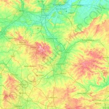
Nome: Mappa topografica Leicestershire, altitudine, rilievo.
Luogo: Leicestershire, England, United Kingdom (52.39217 -1.59755 52.97766 -0.66411)
Altitudine media: 98 m
Altitudine minima: 16 m
Altitudine massima: 269 m
Fai una donazione
Preparati per la tua prossima avventura:
In qualità di associato Amazon, questo sito riceve una commissione sugli acquisti idonei senza alcun costo aggiuntivo per te.
Altre mappe topografiche
Clicca su una mappa per visualizzarne la topografia, l'altitudine e il rilievo.
Fai una donazione
Preparati per la tua prossima avventura:
In qualità di associato Amazon, questo sito riceve una commissione sugli acquisti idonei senza alcun costo aggiuntivo per te.
Fai una donazione
Preparati per la tua prossima avventura:
In qualità di associato Amazon, questo sito riceve una commissione sugli acquisti idonei senza alcun costo aggiuntivo per te.
Kelham Bridge Nature Reserve
United Kingdom > England > Leicestershire > North West Leicestershire > Ravenstone
Altitudine media: 139 m
Market Bosworth Country Park
United Kingdom > England > Leicestershire > Hinckley and Bosworth > Market Bosworth
Altitudine media: 119 m
Fai una donazione
Preparati per la tua prossima avventura:
In qualità di associato Amazon, questo sito riceve una commissione sugli acquisti idonei senza alcun costo aggiuntivo per te.
Coalville
United Kingdom > England > Leicestershire > North West Leicestershire
Altitudine media: 149 m
Fai una donazione
Preparati per la tua prossima avventura:
In qualità di associato Amazon, questo sito riceve una commissione sugli acquisti idonei senza alcun costo aggiuntivo per te.
Fai una donazione
Preparati per la tua prossima avventura:
In qualità di associato Amazon, questo sito riceve una commissione sugli acquisti idonei senza alcun costo aggiuntivo per te.
Isley Walton
United Kingdom > England > Leicestershire > North West Leicestershire
Altitudine media: 76 m
Watermead Country Park
United Kingdom > England > Leicestershire > Charnwood > Birstall
Altitudine media: 59 m
Fai una donazione
Preparati per la tua prossima avventura:
In qualità di associato Amazon, questo sito riceve una commissione sugli acquisti idonei senza alcun costo aggiuntivo per te.
Ratcliffe Culey
United Kingdom > England > Leicestershire > Hinckley and Bosworth
Altitudine media: 77 m
Fai una donazione
Preparati per la tua prossima avventura:
In qualità di associato Amazon, questo sito riceve una commissione sugli acquisti idonei senza alcun costo aggiuntivo per te.
Brocks Hill
United Kingdom > England > Leicestershire > Oadby and Wigston > Oadby
Altitudine media: 102 m
Thringstone
United Kingdom > England > Leicestershire > North West Leicestershire
Altitudine media: 126 m
Adrian's Spinney
United Kingdom > England > Leicestershire > Harborough > Stoughton
Altitudine media: 113 m
Fai una donazione
Preparati per la tua prossima avventura:
In qualità di associato Amazon, questo sito riceve una commissione sugli acquisti idonei senza alcun costo aggiuntivo per te.
Langham Brook
United Kingdom > England > Leicestershire > Melton > Saxby > Freeby
Altitudine media: 94 m
Fai una donazione
Preparati per la tua prossima avventura:
In qualità di associato Amazon, questo sito riceve una commissione sugli acquisti idonei senza alcun costo aggiuntivo per te.
Lount Wood
United Kingdom > England > Leicestershire > North West Leicestershire > Lount
Altitudine media: 131 m
Stretton Baskerville
United Kingdom > England > Leicestershire > Hinckley and Bosworth
Altitudine media: 111 m
Fai una donazione
Preparati per la tua prossima avventura:
In qualità di associato Amazon, questo sito riceve una commissione sugli acquisti idonei senza alcun costo aggiuntivo per te.
Breedon on the Hill
United Kingdom > England > Leicestershire > North West Leicestershire
Altitudine media: 84 m
Fai una donazione
Preparati per la tua prossima avventura:
In qualità di associato Amazon, questo sito riceve una commissione sugli acquisti idonei senza alcun costo aggiuntivo per te.
Bradgate Park
United Kingdom > England > Leicestershire > Charnwood > Newtown Linford
Overlying the Beacon Hill Formation, but found a little further down the hillside to the south, are the Bradgate Formation beds, the most notable of which is the Sliding Stone Slump Breccia rocks. Forming a line of crags below Old John, these are laminated mudstones, with layers of sandstone, mainly of…
Altitudine media: 126 m
Ravenstone
United Kingdom > England > Leicestershire > North West Leicestershire
Altitudine media: 143 m
Nailstone Colliery Railway
United Kingdom > England > Leicestershire > North West Leicestershire > Ibstock
Altitudine media: 155 m
Fai una donazione
Preparati per la tua prossima avventura:
In qualità di associato Amazon, questo sito riceve una commissione sugli acquisti idonei senza alcun costo aggiuntivo per te.
Fenny Drayton
United Kingdom > England > Leicestershire > Hinckley and Bosworth
Altitudine media: 86 m
Long Whatton
United Kingdom > England > Leicestershire > North West Leicestershire
Altitudine media: 63 m
Barton in the Beans
United Kingdom > England > Leicestershire > Hinckley and Bosworth
Altitudine media: 113 m
Higham on the Hill
United Kingdom > England > Leicestershire > Hinckley and Bosworth
Altitudine media: 96 m
Fai una donazione
Preparati per la tua prossima avventura:
In qualità di associato Amazon, questo sito riceve una commissione sugli acquisti idonei senza alcun costo aggiuntivo per te.
Timberwood Hill
United Kingdom > England > Leicestershire > North West Leicestershire
Altitudine media: 192 m
Breedon Cloud Wood
United Kingdom > England > Leicestershire > North West Leicestershire > Breedon on the Hill
Altitudine media: 90 m
Fai una donazione
Preparati per la tua prossima avventura:
In qualità di associato Amazon, questo sito riceve una commissione sugli acquisti idonei senza alcun costo aggiuntivo per te.
Swannymote Rock
United Kingdom > England > Leicestershire > North West Leicestershire > Coalville
Altitudine media: 139 m
Fai una donazione
Preparati per la tua prossima avventura:
In qualità di associato Amazon, questo sito riceve una commissione sugli acquisti idonei senza alcun costo aggiuntivo per te.
Willesley Woods
United Kingdom > England > Leicestershire > North West Leicestershire > Ashby-de-la-Zouch > Willesley
Altitudine media: 108 m
Fai una donazione
Preparati per la tua prossima avventura:
In qualità di associato Amazon, questo sito riceve una commissione sugli acquisti idonei senza alcun costo aggiuntivo per te.
Merry Lees
United Kingdom > England > Leicestershire > Hinckley and Bosworth > Botcheston
Altitudine media: 126 m
Kilby Bridge
United Kingdom > England > Leicestershire > Oadby and Wigston > Wigston
Altitudine media: 89 m
Moat Hill Spinney
United Kingdom > England > Leicestershire > Charnwood > Cotes
Altitudine media: 50 m
Lea Wood
United Kingdom > England > Leicestershire > Charnwood > Newtown Linford
Altitudine media: 170 m
Fai una donazione
Preparati per la tua prossima avventura:
In qualità di associato Amazon, questo sito riceve una commissione sugli acquisti idonei senza alcun costo aggiuntivo per te.
Fai una donazione
Preparati per la tua prossima avventura:
In qualità di associato Amazon, questo sito riceve una commissione sugli acquisti idonei senza alcun costo aggiuntivo per te.
Fai una donazione
Preparati per la tua prossima avventura:
In qualità di associato Amazon, questo sito riceve una commissione sugli acquisti idonei senza alcun costo aggiuntivo per te.
New Lubbesthorpe
United Kingdom > England > Leicestershire > Leicester Forest East
Altitudine media: 95 m
Fai una donazione
Preparati per la tua prossima avventura:
In qualità di associato Amazon, questo sito riceve una commissione sugli acquisti idonei senza alcun costo aggiuntivo per te.
Fai una donazione
Preparati per la tua prossima avventura:
In qualità di associato Amazon, questo sito riceve una commissione sugli acquisti idonei senza alcun costo aggiuntivo per te.
Diseworth
United Kingdom > England > Leicestershire > North West Leicestershire
Altitudine media: 77 m
Fai una donazione
Preparati per la tua prossima avventura:
In qualità di associato Amazon, questo sito riceve una commissione sugli acquisti idonei senza alcun costo aggiuntivo per te.
Old John
United Kingdom > England > Leicestershire > Charnwood > Newtown Linford
Altitudine media: 143 m
Kirkby Mallory
United Kingdom > England > Leicestershire > Hinckley and Bosworth
Altitudine media: 115 m
Fai una donazione
Preparati per la tua prossima avventura:
In qualità di associato Amazon, questo sito riceve una commissione sugli acquisti idonei senza alcun costo aggiuntivo per te.
Fai una donazione
Preparati per la tua prossima avventura:
In qualità di associato Amazon, questo sito riceve una commissione sugli acquisti idonei senza alcun costo aggiuntivo per te.
Six Hills
United Kingdom > England > Leicestershire > Charnwood > Burton on the Wolds
Altitudine media: 128 m
Fai una donazione
Preparati per la tua prossima avventura:
In qualità di associato Amazon, questo sito riceve una commissione sugli acquisti idonei senza alcun costo aggiuntivo per te.