
Mappa topografica Burton Lazars
Clicca sulla mappa per visualizzare l'altitudine.
A proposito di questa mappa
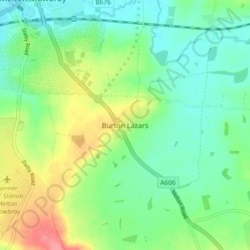
Nome: Mappa topografica Burton Lazars, altitudine, rilievo.
Altitudine media: 96 m
Altitudine minima: 71 m
Altitudine massima: 145 m
Altre mappe topografiche
Clicca su una mappa per visualizzarne la topografia, l'altitudine e il rilievo.
Bottesford
United Kingdom > England > Leicestershire > Melton
Bottesford's many listed buildings include the grade I listed 13th-century Church of St Mary the Virgin. There are two scheduled monuments within the village – Fleming's Bridge and the stone cross in the Market Place. The stocks and whipping post are Grade II listed. One of the Grade II listed buildings,…
Altitudine media: 39 m
Langham Brook
United Kingdom > England > Leicestershire > Melton > Saxby > Freeby
Altitudine media: 94 m
Belvoir Castle
United Kingdom > England > Leicestershire > Melton > Belvoir
The traditional burial place of the Manners family was St Mary the Virgin's Church, Bottesford. Since elevation to the dukedom in 1703 most Dukes have been buried in the grounds of the mausoleum at Belvoir Castle. The mausoleum at Belvoir Castle was built by The 5th Duke of Rutland, following the death of his…
Altitudine media: 82 m
Croxton Kerrial
United Kingdom > England > Leicestershire > Melton > Croxton Kerrial
Altitudine media: 128 m