
Mappa topografica Moray
Clicca sulla mappa per visualizzare l'altitudine.
A proposito di questa mappa
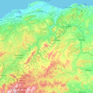
Nome: Mappa topografica Moray, altitudine, rilievo.
Luogo: Moray, Scotland, United Kingdom (57.06845 -3.76579 57.72671 -2.64982)
Altitudine media: 281 m
Altitudine minima: 0 m
Altitudine massima: 1.309 m
Altre mappe topografiche
Clicca su una mappa per visualizzarne la topografia, l'altitudine e il rilievo.
Edinburgh
United Kingdom > Scotland > Edinburgh
Some have called Edinburgh the Athens of the North for a variety of reasons. The earliest comparison between the two cities showed that they had a similar topography, with the Castle Rock of Edinburgh performing a similar role to the Athenian Acropolis. Both of them had flatter, fertile agricultural land…
Altitudine media: 104 m
Glasgow
United Kingdom > Scotland > Glasgow City
Glasgow itself was reputed to have been founded by the Christian missionary Saint Mungo in the 6th century. He established a church on the Molendinar Burn, where the present Glasgow Cathedral stands, and in the following years Glasgow became a religious centre. Glasgow grew over the following centuries. The…
Altitudine media: 128 m
Aberdeen
United Kingdom > Scotland > Aberdeen
Two weather stations collect climate data for the area, Aberdeen/Dyce Airport, and Craibstone. Both are about 4 1⁄2 miles (7 km) to the north west of the city centre, and given that they are in close proximity to each other, exhibit very similar climatic regimes. Dyce tends to have marginally warmer daytime…
Altitudine media: 52 m
Ballater
United Kingdom > Scotland > Aberdeenshire
Ballater (/ˈbælətər/, Scottish Gaelic: Bealadair) is a village in Aberdeenshire, Scotland, on the River Dee, immediately east of the Cairngorm Mountains. Situated at an elevation of 213 metres (699 feet), Ballater is a centre for hikers and known for its spring water, once said to cure scrofula. It is home…
Altitudine media: 360 m
Dundee
United Kingdom > Scotland > Dundee City
Dundee sits on the north bank of the Firth of Tay on the eastern, North Sea Coast of Scotland. The city lies 36.1 miles (58 km) NNE of Edinburgh and 360.6 miles (580 km) NNW of London. The built-up area occupies a roughly rectangular shape 8.3 miles (13 km) long by 2.5 miles (4 km) wide, aligned in an east to…
Altitudine media: 82 m
Airdrie
United Kingdom > Scotland > North Lanarkshire
Airdrie's name first appeared in the Register of the Great Seal of Scotland (Registrum Magni Sigilii Regum Scotorum) in 1373 as Ardre. By 1546 it had become Ardry and by 1587 it was known as Ardrie. In 1630 it finally appeared in the Register as Airdrie. Given the topography of the area, the most likely…
Altitudine media: 135 m
Kirkcaldy
United Kingdom > Scotland > Fife
Towards the end of the 16th century, a detailed assessment on the size of the townscape was carried out. The first estimate of the parish population in 1639 was between 3,000 and 3,200 and around 3,400 by 1691. At the beginning of the 18th century, the population declined. A census by Webster's Topographical…
Altitudine media: 50 m
Kirriemuir
United Kingdom > Scotland > Angus
The family estate of Sir Hugh Munro, who created Munro's Tables of Scottish mountains over 3,000 ft. in elevation (which are now called "munros"), is also located near the town.
Altitudine media: 123 m
Pentland Hills Regional Park
United Kingdom > Scotland > Edinburgh > Peggyslea
Altitudine media: 249 m
Fort William
United Kingdom > Scotland > Highland
Fort William has an oceanic climate (Cfb) with moderate, but generally cool, temperatures and abundant precipitation. In the towns immediate vicinity, there are significant variations in elevation, which leads to some uninhabited areas near the town having a subpolar oceanic climate (Cfc), or, at the absolute…
Altitudine media: 122 m
Ben Nevis
United Kingdom > Scotland > Highland
Ben Nevis has a highland (alpine) maritime (oceanic) polar climate (ET climate in the Köppen classification). Ben Nevis's elevation, maritime location and topography frequently lead to cool and cloudy weather conditions, which can pose a danger to ill-equipped walkers. According to the observations carried…
Altitudine media: 912 m
Ailsa Craig
In a small glen above Ailsa Castle, a small freshwater body known as the Garry Loch is located at an altitude of 247 m (810 ft), with a depth of at least 17 feet.
Altitudine media: 14 m
Mull of Kintyre
Ailsa Craig and the County Antrim coast of Ulster and Rathlin Island are all clearly visible from the Mull. On clearer days it is also possible to make out Malin Head in Inishowen in County Donegal in the west of Ulster, and the Ayrshire coast on the other side of Ailsa Craig. Other islands in the Firth of…
Altitudine media: 84 m
Glasgow
United Kingdom > Scotland > Glasgow City
Glasgow itself was reputed to have been founded by the Christian missionary Saint Mungo in the 6th century. He established a church on the Molendinar Burn, where the present Glasgow Cathedral stands, and in the following years Glasgow became a religious centre. Glasgow grew over the following centuries as part…
Altitudine media: 128 m
Kinlochleven
United Kingdom > Scotland > Highland
Work on the dam and water supply system began in 1905 and was completed in 1907. The hydro-electric scheme was constructed for the British Aluminium Company and was designed by engineer brothers Patrick and Charles Meik. The chief assistant resident engineer on the project was a young William Halcrow. The…
Altitudine media: 306 m
Cumbernauld
United Kingdom > Scotland > North Lanarkshire > Cumbernauld
Cumbernauld's name probably comes from the Gaelic comar nan allt, meaning "meeting of the burns or streams". There are differing views as to the etymology of this. One theory is that from its high point in the Central Belt, its streams flow both west to the River Clyde and east to the Firth of Forth so…
Altitudine media: 111 m
Scottish Highlands
United Kingdom > Scotland > Highland
The Scottish Highlands are renowned for their rugged, mountainous terrain that dominates much of the region. Stretching across the northern and central parts of Scotland, the landscape is shaped by ancient geological forces, including the Caledonian Orogeny, which caused significant tectonic collisions…
Altitudine media: 907 m