Geolocalizza

Mappa topografica Banffshire

Clicca sulla mappa per visualizzare l'altitudine.

A proposito di questa mappa

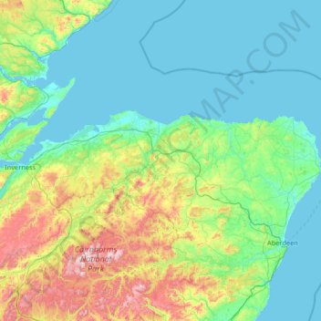
Nome: Mappa topografica Banffshire, altitudine, rilievo.

Luogo: Banffshire, Scotland, AB38 9RN, United Kingdom (56.80000 -3.78333 58.20000 -2.38333)

Altitudine media: 191 m

Altitudine minima: 0 m

Altitudine massima: 1.278 m

Altre mappe topografiche

Clicca su una mappa per visualizzarne la topografia, l'altitudine e il rilievo.

Skye

United Kingdom > Scotland > Highland

Beyond Loch Snizort to the west of Trotternish is the Waternish peninsula, which ends in Ardmore Point's double rock arch. Duirinish peninsula is separated from Waternish by Loch Dunvegan, which contains the island of Isay. It is ringed by sea cliffs that reach 296 metres (971 feet) on the west at Waterstein…

Altitudine media: 63 m

Glen Nevis

United Kingdom > Scotland > Highland > Achriabhach

Altitudine media: 265 m

Glasgow City

United Kingdom > Scotland

Altitudine media: 64 m

City of Edinburgh

United Kingdom > Scotland

Edinburgh has been popularly called the Athens of the North since the early 19th century. References to Athens, such as Athens of Britain and Modern Athens, had been made as early as the 1760s. The similarities were seen to be topographical but also intellectual. Edinburgh's Castle Rock reminded returning…

Altitudine media: 118 m

Highland

United Kingdom > Scotland

Altitudine media: 183 m

Shetland

United Kingdom > Scotland

Walter Scott's 1822 novel The Pirate is set in "a remote part of Shetland", and was inspired by his 1814 visit to the islands. The name Jarlshof meaning "Earl's Mansion" is a coinage of his. Robert Cowie, a doctor born in Lerwick published the 1874 work.Shetland: Descriptive and Historical; Being a Graduation…

Altitudine media: 4 m

River Clyde

United Kingdom > Scotland

Altitudine media: 245 m

Balerno

United Kingdom > Scotland > City of Edinburgh

Altitudine media: 287 m

West Lothian

United Kingdom > Scotland

Altitudine media: 184 m

Perth and Kinross

United Kingdom > Scotland

Altitudine media: 338 m

Loch Lomond

United Kingdom > Scotland > Stirling > Balmaha

Altitudine media: 240 m

Loch Lomond and The Trossachs National Park

United Kingdom > Scotland > Stirling

The park straddles the Highland Boundary Fault, which divides it into two distinct regions - lowland and highland - that differ in underlying geology, soil types and topography. The change in rock type can most clearly be seen at Loch Lomond itself, as the fault runs across the islands of Inchmurrin, Creinch,…

Altitudine media: 291 m

Moray

United Kingdom > Scotland

Altitudine media: 281 m

Orkney Islands

United Kingdom > Scotland

The southern group of islands surrounds Scapa Flow. Hoy, to the west, is the second largest of the Orkney Isles and Ward Hill at its northern end is the highest elevation in the archipelago. The Old Man of Hoy is a well-known seastack. Graemsay and Flotta are both linked by ferry to the Mainland and Hoy, and…

Altitudine media: 7 m

Hebrides

United Kingdom > Scotland

Altitudine media: 94 m

Fife

United Kingdom > Scotland

Altitudine media: 67 m

Midlothian

United Kingdom > Scotland

Altitudine media: 236 m

North Lanarkshire

United Kingdom > Scotland

Altitudine media: 149 m

South Lanarkshire

United Kingdom > Scotland

Altitudine media: 289 m

Aberdeen City

United Kingdom > Scotland

Two weather stations collect climate data for the area, Aberdeen/Dyce Airport, and Craibstone. Both are about 4+1⁄2 miles (7 km) to the north west of the city centre, and given that they are in close proximity to each other, exhibit very similar climatic regimes. Dyce tends to have marginally warmer daytime…

Altitudine media: 46 m

Angus

United Kingdom > Scotland

Angus can be split into three geographic areas. To the north and west, the topography is mountainous. This is the area of the Grampian Mountains, Mounth hills and Five Glens of Angus, which is sparsely populated and where the main industry is hill farming. Glas Maol – the highest point in Angus at 1,068 m…

Altitudine media: 254 m

East Lothian

United Kingdom > Scotland

Altitudine media: 132 m

Lewis and Harris

United Kingdom > Scotland

Altitudine media: 28 m

Dundee City

United Kingdom > Scotland

Altitudine media: 74 m

Argyll and Bute

United Kingdom > Scotland

Altitudine media: 84 m

Caithness

United Kingdom > Scotland

Caithness extends about 30 miles (48 km) north-south and about 30 miles (48 km) east-west, with a roughly triangular-shaped area of about 712 sq mi (1,840 km2). The topography is generally flat, in contrast to the majority of the remainder of the North of Scotland. Until the latter part of the 20th century…

Altitudine media: 79 m

South Ayrshire

United Kingdom > Scotland

The number of hours of natural sunshine in South Ayrshire is controlled by the length of day and by cloudiness. In general, December is the dullest month and May or June the sunniest. Sunshine duration decreases with increasing altitude, increasing latitude and distance from the coast. Local topography also…

Altitudine media: 151 m

Scottish Borders

United Kingdom > Scotland

Altitudine media: 257 m

Renfrewshire

United Kingdom > Scotland

Altitudine media: 104 m

Aberdeenshire

United Kingdom > Scotland

Altitudine media: 199 m

North Ayrshire

United Kingdom > Scotland

Altitudine media: 80 m

East Ayrshire

United Kingdom > Scotland

East Ayrshire is located on the west coat of Scotland, sharing borders with the following neighbouring council areas; North Ayrshire, South Ayrshire, Dumfries and Galloway, East Renfrewshire and South Lanarkshire. Blackcraig Hill reaches an elevation of 2,298 feet (700 metres), the highest peak in East…

Altitudine media: 225 m

South Queensferry

United Kingdom > Scotland

Altitudine media: 31 m

Moray

United Kingdom > Scotland

Altitudine media: 280 m

River Tweed

United Kingdom > Scotland

Altitudine media: 236 m

Inchmickery

United Kingdom > Scotland

Altitudine media: 0 m

Ailsa Craig

United Kingdom > Scotland

In a small glen above Ailsa Castle, a small freshwater body known as the Garry Loch is located at an altitude of 247 m (810 ft), with a depth of at least 17 feet.

Altitudine media: 14 m

Iona

United Kingdom > Scotland

Altitudine media: 9 m

Glen Dochart

United Kingdom > Scotland

Altitudine media: 469 m

Falkirk

United Kingdom > Scotland

Altitudine media: 105 m

Denton Burn

United Kingdom > Scotland

Altitudine media: 154 m

Taynish Island

United Kingdom > Scotland

Altitudine media: 11 m

River Kerry

United Kingdom > Scotland

Altitudine media: 118 m

River Dee

United Kingdom > Scotland

Altitudine media: 299 m

River Don

United Kingdom > Scotland

Altitudine media: 257 m

Papa

United Kingdom > Scotland

Altitudine media: 2 m

Loch Urigill

United Kingdom > Scotland

Altitudine media: 172 m

Highland

United Kingdom > Scotland

Altitudine media: 402 m

Snap

United Kingdom > Scotland

Altitudine media: 3 m

Stirling

United Kingdom > Scotland

Altitudine media: 293 m

East Dunbartonshire

United Kingdom > Scotland

Altitudine media: 161 m

West Dunbartonshire

United Kingdom > Scotland

Altitudine media: 101 m

Clackmannanshire

United Kingdom > Scotland

Altitudine media: 175 m

Western Isles

United Kingdom > Scotland

Altitudine media: 57 m

East Renfrewshire

United Kingdom > Scotland

Altitudine media: 163 m

Inverclyde

United Kingdom > Scotland

Altitudine media: 141 m

River Spey

United Kingdom > Scotland

Altitudine media: 336 m

The Minch

United Kingdom > Scotland

Altitudine media: 63 m

St Magnus' Bay

United Kingdom > Scotland

Altitudine media: 6 m

Dunipace

United Kingdom > Scotland > Falkirk

Altitudine media: 67 m

East Kilbride

United Kingdom > Scotland > East Kilbride

Altitudine media: 177 m

Whitebridge

United Kingdom > Scotland > Highland

Altitudine media: 223 m

Achmelvich

United Kingdom > Scotland > Highland

Altitudine media: 58 m

Loch Tulla

United Kingdom > Scotland > Argyll and Bute

Altitudine media: 210 m

Lake of Menteith

United Kingdom > Scotland > Stirling

Altitudine media: 31 m

Applecross

United Kingdom > Scotland > Highland

Altitudine media: 149 m

Dunfermline

United Kingdom > Scotland > Fife

Altitudine media: 114 m

Kingswells

United Kingdom > Scotland > Aberdeen City

Altitudine media: 151 m

Campsie Fells

United Kingdom > Scotland > Stirling

Altitudine media: 156 m

Loch Affric

United Kingdom > Scotland > Highland

A number of smaller lochs surround Loch Affric. At the southwestern end sits Loch Coulavie located at the base An Tudair Beag and a slightly higher elevation. Also, at the southwestern end, the river Affric flows into the tiny loch of Loch na Camaig. At the northeastern side, Loch Pollan Fearna drains into…

Altitudine media: 477 m

Loch Venachar

United Kingdom > Scotland > Stirling

Altitudine media: 219 m

Wormington

United Kingdom > Scotland > Scottish Borders

Altitudine media: 172 m

Trinity

United Kingdom > Scotland > City of Edinburgh

Altitudine media: 17 m

North Rona

United Kingdom > Scotland > Western Isles

Rona (Scottish Gaelic: Rònaigh) is an uninhabited Scottish island in the North Atlantic. It is often referred to as North Rona to distinguish it from the island of South Rona in the Inner Hebrides. It has an area of 109 hectares (270 acres) and a maximum elevation of 108 metres (354 ft).

Altitudine media: 4 m

Dechmont

United Kingdom > Scotland > West Lothian

Altitudine media: 155 m

Callander

United Kingdom > Scotland > Stirling

Altitudine media: 125 m

Coll

United Kingdom > Scotland > Argyll and Bute > Arinagour

Altitudine media: 7 m

Quinag

United Kingdom > Scotland > Highland

Altitudine media: 368 m

River South Esk

United Kingdom > Scotland > Angus

Altitudine media: 287 m

Loch Muick

United Kingdom > Scotland > Aberdeenshire

Altitudine media: 529 m

Loch Veyatie

United Kingdom > Scotland > Highland

Altitudine media: 248 m

Heisker

United Kingdom > Scotland > Western Isles

Altitudine media: 0 m

Stronsay

United Kingdom > Scotland > Orkney Islands > Whitehall

Stronsay (/ˈstrɒnziː/) is an island in Orkney, Scotland. It is known as Orkney's 'Island of Bays', owing to an irregular shape with miles of coastline, with three large bays separated by two isthmuses: St Catherine's Bay to the west, the Bay of Holland to the south and Mill Bay to the east. Stronsay is…

Altitudine media: 4 m

South Havra

United Kingdom > Scotland > Shetland

Altitudine media: 1 m

Dunfermline

United Kingdom > Scotland > Fife > Dunfermline

Altitudine media: 80 m

Preparati per la tua prossima avventura:

🚲Borse da Cicloturismo - Sistemi di carico per esplorare percorsi topografici su due ruote
🪢Corde outdoor - Utili per campeggio e trekking
🔥Acciarini e Fuoco - Strumenti per accendere il fuoco in qualsiasi condizione meteo
🧊Borse Frigo e Ghiaccio - Soluzioni per mantenere freschi cibi e bevande durante le gite
🎒Zaini da trekking - Zaini tecnici per escursioni giornaliere o di più giorni

In qualità di associato Amazon, questo sito riceve una commissione sugli acquisti idonei senza alcun costo aggiuntivo per te.