
Mappa topografica Sikkim
Clicca sulla mappa per visualizzare l'altitudine.
Sikkim
Situated in the Himalayan mountains, the state of Sikkim is characterised by mountainous terrain. Almost the entire state is hilly, with an elevation ranging from 280 metres (920 ft) in the south at the border with West Bengal to 8,586 metres (28,169 ft) in northern peaks near Nepal and Tibet. The summit of Kangchenjunga, the world's third-highest peak, is the state's highest point, situated on the border between Sikkim and Nepal. For the most part, the land is unfit for agriculture because of the rocky, precipitous slopes. However, some hill slopes have been converted into terrace farms.
A proposito di questa mappa
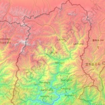
Nome: Mappa topografica Sikkim, altitudine, rilievo.
Luogo: Sikkim, India (27.07926 88.01203 28.12405 88.92117)
Altitudine media: 3.786 m
Altitudine minima: 264 m
Altitudine massima: 8.434 m
Altre mappe topografiche
Clicca su una mappa per visualizzarne la topografia, l'altitudine e il rilievo.
Surat
India > Gujarat > Katargam Taluka > Surat
Surat is a port city situated on the banks of the Tapi river. Damming of the Tapi caused the original port facilities to close; the nearest port is now in the Magadalla and Hazira area of Surat Metropolitan Region.It has famous beach called 'Dumas Beach' located in Hazira. The city is located at 21°10′N…
Altitudine media: 11 m
Vadodara
India > Gujarat > Vadodara Rural Taluka
Vadodara is located at 22°18′N 73°11′E / 22.30°N 73.19°E / 22.30; 73.19 in western India at an elevation of 39 metres (128 ft). It is the tenth-largest city in India with an area of 400 square kilometres (150 sq mi) and a population of 3.5 million, according to the 2010–11 census. The city…
Altitudine media: 36 m
Maharashtra
Maharashtra is the third largest state by area in India. The Western Ghats better known as Sahyadri, are a hilly range running parallel to the coast, at an average elevation of 1,200 metres (4,000 ft). Kalsubai, a peak in the Sahyadris, near Nashik city is the highest elevated point in Maharashtra. To the west…
Altitudine media: 478 m
Thiruvananthapuram
India > Kerala > Thiruvananthapuram
Thiruvananthapuram is built on seven hills by the seashore and is at 8°30′N 76°54′E / 8.5°N 76.9°E / 8.5; 76.9 on the west coast, near the southern tip of mainland India. The city is on the west coast of India and is bounded by the Laccadive Sea to its west and the Western Ghats to its east.…
Altitudine media: 33 m
Gorakhpur
India > Uttar Pradesh > Gorakhpur
Gorakhpur city is located in the north-easterrn part of Uttar Pradesh, India, within the Indo-Gangetic Plain. The city's geographical coordinates are 26.7663° N latitude and 83.3689° E longitude, with an altitude of 69 metres (229 feet) above sea level. Gorakhpur is situated about 100 km from the Nepal…
Altitudine media: 79 m
Kargil
India > Ladakh > Kargil tehsil
Kargil has an average elevation of 2,676 metres (8,780 feet), and is situated along the banks of the Suru River (Indus). The town of Kargil is located 205 km (127 mi) from Srinagar, facing the Northern Areas across the LOC. Like other areas in the Himalayas, Kargil has a temperate climate. Summers are hot with…
Altitudine media: 3.262 m
Ujjain
India > Madhya Pradesh > Ujjain NagarTahsil
Ujjain is located in the west-central part of India, and is north of the upper limit of the Vindhya mountain ranges. Located on the Malwa plateau, it is higher than the north Indian plains and the land rises towards the Vindhya Range to the south. Ujjain's co-ordinates are 23°10′N 75°46′E /…
Altitudine media: 501 m
Handwara
India > Jammu and Kashmir > Handwara tehsil
Handwara is located at 34°24′N 74°17′E / 34.40°N 74.28°E / 34.40; 74.28 at an average elevation of 1,582 metres (5,190 feet) above sea level.
Altitudine media: 1.638 m
Dehradun
India > Uttarakhand > Dehradun
The city of Dehradun mainly lies in Doon Valley and is at a varying height from 410 m (1,350 ft) in Clement Town to above 700 m (2,300 ft) at Malsi which is 15 km (9.3 mi) from the city. However, the average elevation is 450 m (1,480 ft) above sea level. Malsi is the starting point of Lesser Himalayan Range…
Altitudine media: 904 m
Mumbai
Mumbai lies at the mouth of the Ulhas River on the western coast of India, in the coastal region known as the Konkan. It sits on Salsette Island (Sashti Island), which it partially shares with the Thane district. Mumbai is bounded by the Arabian Sea to the west. Many parts of the city lie just above sea level,…
Altitudine media: 13 m
Bhubaneshwar
India > Odisha > Bhubaneswar (M.Corp.)
Bhubaneswar is in Khordha district of Odisha. It is in the eastern coastal plains, along the axis of the Eastern Ghats mountains. The city has an average altitude of 45 m (148 ft) above sea level. It lies southwest of the Mahanadi River that forms the northern boundary of Bhubaneswar metropolitan area, within…
Altitudine media: 30 m
Vadodara
India > Gujarat > Vadodara Rural Taluka
Vadodara is located at 22°18′N 73°11′E / 22.30°N 73.19°E / 22.30; 73.19 in western India at an elevation of 39 metres (128 ft). It is the tenth-largest city in India with an area of 400 square kilometres (150 sq mi) and a population of 3.5 million, according to the 2010–11 census. The city…
Altitudine media: 36 m
Guwahati
Professor Abani Kumar Bhagawati of Gauhati University stated that since before there were sufficient wetlands to absorb rainwater and channels to carry excess water to the Brahmaputra, the city did not experience floods. However, human interference has disrupted the natural topography, leading to the current…
Altitudine media: 113 m
Rajsamand
India > Rajasthan > Rajsamand Tehsil
Rajsamand is located at 25°04′N 73°53′E / 25.07°N 73.88°E / 25.07; 73.88. It has an average elevation of 547 metres (1794 ft).
Altitudine media: 552 m
Uluberia
India > West Bengal > Uluberia - I
Uluberia is located at 22°28′N 88°07′E / 22.47°N 88.11°E / 22.47; 88.11. It has an average elevation of 1 m (3.3 ft). It is situated on the banks of the river Hooghly. The main road passing through the heart of the city is Orissa trunk road and is also well connected by National Highway 16.…
Altitudine media: 5 m
Mahad
India > Maharashtra > Mahad Taluka
Several disasters like floods and landslides have continuously devastated markets and old houses, specifically classic Konkani-styled architecture, causing great loss of life. This is primarily due to lower elevation of the city compared to surrounding areas and being surrounded by rivers on all sides, making…
Altitudine media: 75 m
Yamuna River
The source of Yamuna lies in the Yamunotri Glacier at an elevation of 6,387 metres (20,955 ft), on the southwestern slopes of Banderpooch peaks, which lie in the Mussoorie range of the Lower Himalayas, north of Haridwar in Uttarkashi district, Uttarakhand. Yamunotri temple, a shrine dedicated to the goddess…
Altitudine media: 206 m
Shimla
Shimla is on the south-western ranges of the Himalayas at 31°37′N 77°06′E / 31.61°N 77.10°E / 31.61; 77.10. It has an average altitude of 2,206 metres (7,238 ft) above mean sea level and extends along a ridge with seven spurs. The city stretches nearly 9.2 kilometres (5.7 mi) from east to west.
Altitudine media: 1.557 m
Mangaluru
India > Karnataka > Mangaluru taluk
Mangalore is also the administrative headquarters of the Dakshina Kannada district; it is a commercial, industrial, educational, healthcare, and startup hub. The city's international airport is the second-largest and second-busiest airport in Karnataka. Mangalore City Corporation is responsible for the civic…
Altitudine media: 25 m
Visakhapatnam
India > Andhra Pradesh > Visakhapatnam Urban
The city is situated between the Eastern Ghats and the Bay of Bengal. The city coordinates lies between 17.7041 N and 83.2977 E. The city's area is 682 km2. The average elevation is 45 metres. Visakhpatnam is situated in Coastal Andhra Region.
Altitudine media: 35 m
Bhopal
India > Madhya Pradesh > Huzur Tahsil
Bhopal has an average elevation of 500 metres (1401 ft) and is located in the central part of India, just north of the upper limit of the Vindhya mountain ranges. Located on the Malwa plateau, it is higher than the north Indian plains and the land rises towards the Vindhya Range to the south. The city has…
Altitudine media: 498 m
Madurai
India > Tamil Nadu > Madurai
Madurai is located at 9°56′N 78°07′E / 9.93°N 78.12°E / 9.93; 78.12. It has an average elevation of 101 metres. The city of Madurai lies on the flat and fertile plain of the river Vaigai, which runs in the northwest-southeast direction through the city, dividing it into two almost equal…
Altitudine media: 138 m
Pimpri-Chinchwad
India > Maharashtra > Haveli Subdistrict
Pimpri-Chinchwad also known as "PCMC", is a city in the Indian state of Maharashtra. The city is about 15 km (9.3 mi) northwest of the historic city of Pune, at an altitude of 590 m (1,940 ft) above sea level. It is the fifth largest city in Maharashtra and the nineteenth largest city in India and the…
Altitudine media: 605 m
Sultan Bathery
India > Kerala > Sulthanbathery
Sulthan Bathery is located at 11°40′N 76°17′E / 11.67°N 76.28°E / 11.67; 76.28. It has an average elevation of 907 m (2,976 ft).
Altitudine media: 876 m
Jammu
India > Jammu and Kashmir > Jammu
Jammu is located at 32°44′N 74°52′E / 32.73°N 74.87°E / 32.73; 74.87. It has an average elevation of 300 m (980 ft). Jammu city lies at uneven ridges of low heights at the Shivalik hills. It is surrounded by the Shivalik range to the north, east, and southeast while the Trikuta Range surrounds…
Altitudine media: 367 m
Lucknow
India > Uttar Pradesh > Lucknow
The city stands at an elevation of approximately 123 metres (404 ft) above sea level. Lucknow city had an area of 402 km2 (155 square miles) till December 2019, when 88 villages were added to the municipal limits and the area increased to 631 km2 (244 square miles). Bounded on the east by Barabanki, on the…
Altitudine media: 120 m
Srinagar
India > Jammu and Kashmir > Srinagar (South)
Under the Köppen climate classification, Srinagar has a four-season humid subtropical climate (Cfa) with hot summers and cool winters. The valley is surrounded by the Himalayas on all sides. Due to influence from Himalayan rain shadow and western disturbances, Srinagar has year-round precipitation; the spring…
Altitudine media: 1.805 m
Rajkot
India > Gujarat > Rajkot East Taluka
Rajkot is located at 22°18′N 70°47′E / 22.3°N 70.78°E / 22.3; 70.78. It has an average elevation of 128 metres (420 ft). The city is located on the bank of Aji River and Nyari River which remains dry except the monsoon months of July to September. The city is spread in the area of 170.00 km².
Altitudine media: 141 m
Navi Mumbai
India > Maharashtra > Thane > Navi Mumbai
Navi Mumbai (Marathi pronunciation: , also known by its former name New Bombay), is a planned city off the west coast of the Indian state of Maharashtra in Konkan division. The city is divided into two parts, North Navi Mumbai and South Navi Mumbai, for the individual development of Panvel Mega City, which…
Altitudine media: 30 m
Ranchi
Ranchi lies at 23°22′N 85°20′E / 23.36°N 85.33°E / 23.36; 85.33 near to the Tropic of Cancer. The city covers an area of 175 km2 (68 sq mi) and its average elevation is 651 m above sea level. Ranchi is located in the southern part of the Chota Nagpur plateau, which is the eastern section of…
Altitudine media: 648 m