
Fai una donazione
Preparati per la tua prossima avventura:
In qualità di associato Amazon, questo sito riceve una commissione sugli acquisti idonei senza alcun costo aggiuntivo per te.
Mappa topografica Darnestown
Clicca sulla mappa per visualizzare l'altitudine.
Fai una donazione
Preparati per la tua prossima avventura:
In qualità di associato Amazon, questo sito riceve una commissione sugli acquisti idonei senza alcun costo aggiuntivo per te.
Darnestown
In the 2000 census, the Census Bureau created a new Census-designated place (CDP) called Darnestown. A Darnestown CDP was also used in the 2010 census. The Darnestown CDP has 16.39 square miles (42.4 km2) of land, which is smaller than the old Darnestown MCD. The CDP uses the Muddy Branch, Turkey Foot Road, and Jones Lane for most of its eastern border instead of rivers further east. The MCD territory between Little Seneca Creek and the north side of Great Seneca Creek is also not part of the Darnestown CDP. Great Seneca Creek remains as the western border. Washington, D.C. is roughly 25 miles (40 km) away. The Travilah and North Potomac CDPs are along the Darnestown CDP's eastern border. The United States Geological Survey lists ten Darnestown-related features, including the Darnestown Census Designated Place with an elevation of 377 feet (115 m) and the Darnestown populated place (a.k.a. Darnestown village) has an elevation of 440 feet (130 m).
Fai una donazione
Preparati per la tua prossima avventura:
In qualità di associato Amazon, questo sito riceve una commissione sugli acquisti idonei senza alcun costo aggiuntivo per te.
A proposito di questa mappa
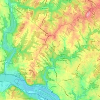
Nome: Mappa topografica Darnestown, altitudine, rilievo.
Luogo: Darnestown, Montgomery County, Maryland, United States (39.04629 -77.34358 39.13403 -77.24729)
Altitudine media: 97 m
Altitudine minima: 47 m
Altitudine massima: 154 m
Fai una donazione
Preparati per la tua prossima avventura:
In qualità di associato Amazon, questo sito riceve una commissione sugli acquisti idonei senza alcun costo aggiuntivo per te.
Altre mappe topografiche
Clicca su una mappa per visualizzarne la topografia, l'altitudine e il rilievo.
Fai una donazione
Preparati per la tua prossima avventura:
In qualità di associato Amazon, questo sito riceve una commissione sugli acquisti idonei senza alcun costo aggiuntivo per te.
Fai una donazione
Preparati per la tua prossima avventura:
In qualità di associato Amazon, questo sito riceve una commissione sugli acquisti idonei senza alcun costo aggiuntivo per te.
Great Falls
United States > Maryland > Montgomery County > Potomac
The rocks of the falls date to the late Precambrian and are about 750 million years old. The rocks are a resistant metamorphized schist, gneisses, metagraywackes, and metaconglomerates. The Falls formed the last time sea level dropped, during the Last Glacial Period about 35,000 years ago, causing the Potomac…
Altitudine media: 73 m
Fai una donazione
Preparati per la tua prossima avventura:
In qualità di associato Amazon, questo sito riceve una commissione sugli acquisti idonei senza alcun costo aggiuntivo per te.
Seneca
United States > Maryland > Montgomery County > Darnestown
Seneca is located close to the intersection of River Road (Maryland Route 190), Seneca Road (Maryland route 112), and Rileys Lock Road, east of Great Seneca Creek and north of the Potomac River. The C&O Canal runs along the river, and Riley's Lock is the closest canal lock. The southern portion of Seneca Creek…
Altitudine media: 82 m
Fai una donazione
Preparati per la tua prossima avventura:
In qualità di associato Amazon, questo sito riceve una commissione sugli acquisti idonei senza alcun costo aggiuntivo per te.
Fai una donazione
Preparati per la tua prossima avventura:
In qualità di associato Amazon, questo sito riceve una commissione sugli acquisti idonei senza alcun costo aggiuntivo per te.
Fai una donazione
Preparati per la tua prossima avventura:
In qualità di associato Amazon, questo sito riceve una commissione sugli acquisti idonei senza alcun costo aggiuntivo per te.
Rockcrest
United States > Maryland > Montgomery County > Rockville > Rockcrest
Altitudine media: 114 m
Fai una donazione
Preparati per la tua prossima avventura:
In qualità di associato Amazon, questo sito riceve una commissione sugli acquisti idonei senza alcun costo aggiuntivo per te.
Brookeville Heights
United States > Maryland > Montgomery County > Brookeville Heights
Altitudine media: 139 m
Garrett Park Estates
United States > Maryland > Montgomery County > Garrett Park Estates
Altitudine media: 97 m
Fai una donazione
Preparati per la tua prossima avventura:
In qualità di associato Amazon, questo sito riceve una commissione sugli acquisti idonei senza alcun costo aggiuntivo per te.