
Fai una donazione
Preparati per la tua prossima avventura:
In qualità di associato Amazon, questo sito riceve una commissione sugli acquisti idonei senza alcun costo aggiuntivo per te.
Mappa topografica Great Falls
Clicca sulla mappa per visualizzare l'altitudine.
Fai una donazione
Preparati per la tua prossima avventura:
In qualità di associato Amazon, questo sito riceve una commissione sugli acquisti idonei senza alcun costo aggiuntivo per te.
Great Falls
The rocks of the falls date to the late Precambrian and are about 750 million years old. The rocks are a resistant metamorphized schist, gneisses, metagraywackes, and metaconglomerates. The Falls formed the last time sea level dropped, during the Last Glacial Period about 35,000 years ago, causing the Potomac to downcut its valley. The river cascades over a series of 20-foot (6.1 m) falls, dropping a total of 76 feet (23 m) in elevation over a distance of less than 1 mile (1.6 km). As sea level rises again, the power of the falls will be reduced due to a shorter vertical drop and likewise downcutting will slow down. Should the ocean level ever exceed the height of the falls again, downcutting would reverse entirely with silt filling in the now-underwater falls.
Fai una donazione
Preparati per la tua prossima avventura:
In qualità di associato Amazon, questo sito riceve una commissione sugli acquisti idonei senza alcun costo aggiuntivo per te.
A proposito di questa mappa
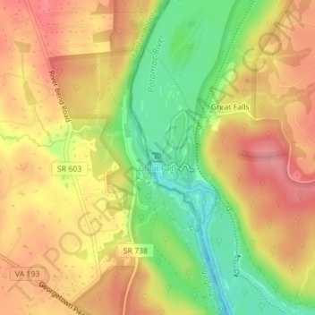
Nome: Mappa topografica Great Falls, altitudine, rilievo.
Altitudine media: 73 m
Altitudine minima: 17 m
Altitudine massima: 115 m
Fai una donazione
Preparati per la tua prossima avventura:
In qualità di associato Amazon, questo sito riceve una commissione sugli acquisti idonei senza alcun costo aggiuntivo per te.