
Fai una donazione
Preparati per la tua prossima avventura:
In qualità di associato Amazon, questo sito riceve una commissione sugli acquisti idonei senza alcun costo aggiuntivo per te.
Mappa topografica Seneca
Clicca sulla mappa per visualizzare l'altitudine.
Fai una donazione
Preparati per la tua prossima avventura:
In qualità di associato Amazon, questo sito riceve una commissione sugli acquisti idonei senza alcun costo aggiuntivo per te.
Seneca
Seneca is located close to the intersection of River Road (Maryland Route 190), Seneca Road (Maryland route 112), and Rileys Lock Road, east of Great Seneca Creek and north of the Potomac River. The C&O Canal runs along the river, and Riley's Lock is the closest canal lock. The southern portion of Seneca Creek State Park is nearby, as is the Bretton Woods Golf Course. The United States Geological Survey (USGS) lists the community's elevation as 187 feet (57 meters).
Fai una donazione
Preparati per la tua prossima avventura:
In qualità di associato Amazon, questo sito riceve una commissione sugli acquisti idonei senza alcun costo aggiuntivo per te.
A proposito di questa mappa
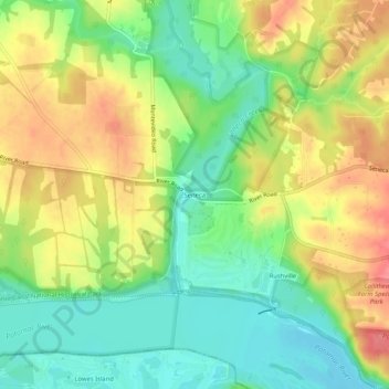
Nome: Mappa topografica Seneca, altitudine, rilievo.
Altitudine media: 82 m
Altitudine minima: 48 m
Altitudine massima: 122 m
Fai una donazione
Preparati per la tua prossima avventura:
In qualità di associato Amazon, questo sito riceve una commissione sugli acquisti idonei senza alcun costo aggiuntivo per te.