
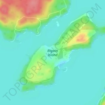
Mappa topografica Bigwin Island
Clicca sulla mappa per visualizzare l'altitudine.
A proposito di questa mappa
Nome: Mappa topografica Bigwin Island, altitudine, rilievo.
Altitudine media: 328 m
Altitudine minima: 307 m
Altitudine massima: 389 m
Altre mappe topografiche
Clicca su una mappa per visualizzarne la topografia, l'altitudine e il rilievo.
Toronto
Despite its deep ravines, Toronto is not remarkably hilly, but its elevation does increase steadily away from the lake. Elevation differences range from 76.5 metres (251 ft) above sea level at the Lake Ontario shore to 209 m (686 ft) ASL near the York University grounds in the city's north end at the…
Altitudine media: 113 m
Ottawa
Ottawa, the capital city of Canada, is situated on the south bank of the Ottawa River at the confluence with the Rideau River. The city's topography is characterized by gently rolling terrain with elevations ranging from approximately 44 meters (144 feet) above sea level at the Ottawa River to its highest…
Altitudine media: 105 m
London
Canada > Ontario > London > London
London has a humid continental climate (Köppen Dfb), though due to its downwind location relative to Lake Huron and elevation changes across the city, it is virtually on the Dfa/Dfb (hot summer) boundary favouring the former climate zone to the southwest of the confluence of the South and North Thames Rivers,…
Altitudine media: 268 m
Toronto
Despite its deep ravines, Toronto is not remarkably hilly, but its elevation does increase steadily away from the lake. Elevation differences range from 76.5 metres (251 ft) above sea level at the Lake Ontario shore to 209 m (686 ft) above sea level near the York University grounds in the city's north end at…
Altitudine media: 139 m
Toronto
Despite its deep ravines, Toronto is not remarkably hilly, but its elevation does increase steadily away from the lake. Elevation differences range from 76.5 metres (251 ft) above sea level at the Lake Ontario shore to 209 m (686 ft) ASL near the York University grounds in the city's north end at the…
Altitudine media: 139 m
Markham
Canada > Ontario > York Region
Markham's average altitude is at 200 m (660 ft) and in general consists of gently rolling hills. The city is intersected by two rivers; the Don River and Rouge River, as well as their tributaries. To the north is the Oak Ridges Moraine, which further elevates the elevation towards the north.
Altitudine media: 216 m
Kitchener
Canada > Ontario > Region of Waterloo
Kitchener is located in Southwestern Ontario, in the Saint Lawrence Lowlands. This geological and climatic region has wet-climate soils and deciduous forests. Situated in the Grand River Valley, the area is generally above 300 m (1,000 ft) in elevation.
Altitudine media: 336 m
Peterborough
Canada > Ontario > Peterborough
Peterborough's topography is largely defined by land formations created by the receding Wisconsian glaciers 10,000–15,000 years ago. The South End and Downtown portions of the City sit on what was the bottom of the glacial Lake Peterborough—part of a glacial spillway created when glacial meltwaters from…
Altitudine media: 235 m
Guelph
This region of Ontario has cold winters and warm, humid summers, falling into the Köppen climate classification Dfb zone, with moderately high rainfall and snowfall. It is generally a couple of degrees cooler than lower elevation regions on the Great Lakes shorelines, especially so in winter, the exception…
Altitudine media: 344 m
Lake Ontario
Lake Ontario is the easternmost of the Great Lakes and the smallest in surface area (7,340 sq mi, 18,960 km2), although it exceeds Lake Erie in volume (393 cu mi, 1,639 km3). It is the 13th largest lake in the world. When its islands are included, the lake's shoreline is 712 miles (1,146 km) long. As the last…
Altitudine media: 214 m
North Bay
Canada > Ontario > Nipissing District
The climate in North Bay is common to most places in Northern Ontario. North Bay tends to be a less humid climate than that found in Southern Ontario due somewhat to the distance from the Great Lakes and less warm than some other locations in Northern Ontario due to cooling from Lake Nipissing. On May 31,…
Altitudine media: 266 m
Mississauga
Canada > Ontario > Peel Region
The shoreline of former Glacial Lake Iroquois roughly follows the Dundas Street alignment, although it is not noticeable in some places but is more prominent in others, such as the site of the former brickyard (Shoreline Dr. near Mavis Rd.), the ancient shoreline promenteau affords a clear view of downtown…
Altitudine media: 151 m
Hamilton
The airport's open, rural location and higher altitude results in lower temperatures, generally windier conditions, and higher snowfall amounts than lower, built-up areas of the city. The highest temperature ever recorded in Hamilton was 41.1 °C (106 °F) on July 14, 1868. The coldest temperature ever…
Altitudine media: 187 m
Port Loring
Canada > Ontario > Parry Sound District > Unorganized Centre Parry Sound
Altitudine media: 227 m
Upsala
Canada > Ontario > Thunder Bay District > Unorganized Thunder Bay District
Altitudine media: 487 m
Trent Lakes
Canada > Ontario > Peterborough County
The lumber and agricultural industries are significant to the history of the township. Due to the topography of the region, agricultural production was limited to only certain areas where soil conditions were adequate and cattle and mixed farming (orchards, cattle, horses, sheep, grains, vegetables, chickens…
Altitudine media: 293 m
Simcoe County
The road network in Simcoe County is based on a grid pattern, with most roads running north–south or east–west. The topography of the land has permitted roads to be set in predominantly straight lines.
Altitudine media: 265 m
Sarnia
Canada > Ontario > Lambton County
Sarnia is located on the eastern shore of Lake Huron at its extreme southern point, where it flows into the St. Clair River. Most of the surrounding area is flat, and the elevation ranges from 169 metres (554 ft) and 281 metres (922 ft) above sea level. The soil mostly comprises clay. Despite this high…
Altitudine media: 186 m
Lake Nipissing
Canada > Ontario > Nipissing District
Lake Nipissing (/ˈnɪpəsɪŋ/; French: lac Nipissing, Ojibwe: Gichi-nibiinsing-zaaga’igan) is a lake in the Canadian province of Ontario. It has a surface area of 873.3 km2 (337.2 sq mi), a mean elevation of 196 m (643 ft) above sea level, and is located between the Ottawa River and Georgian Bay. Lake…
Altitudine media: 272 m
Guthrie Lake
Canada > Ontario > Nipissing District > Unorganized South Nipissing
Altitudine media: 299 m
London
London has a humid continental climate (Köppen Dfb), though due to its downwind location relative to Lake Huron and elevation changes across the city, it is virtually on the Dfa/Dfb (hot summer) boundary favouring the former climate zone to the southwest of the confluence of the South and North Thames Rivers,…
Altitudine media: 263 m
Eastern Ontario
Along the extreme western edge of Eastern Ontario is a continuation of the Laurentian Highlands, known as the Opeongo Hills, and they contain some of the highest elevations in Southern Ontario. They stretch into the northern portions of Central Ontario, near Algonquin Provincial Park.
Altitudine media: 243 m
Larder Lake
Canada > Ontario > Timiskaming District > Larder Lake Township > Larder Lake
Altitudine media: 302 m
St. Catharines
Canada > Ontario > Niagara Region
The most defining transportation icon of St. Catharines is the Welland Canal, a ship canal that runs 43.4 kilometres (27.0 mi), passing through the city. Four of its locks are within city boundaries. The canal allows shipping vessels to traverse the 99.5-metre (326.5 ft) drop in altitude from Lake Erie to Lake…
Altitudine media: 103 m
Peterborough
Peterborough's topography is largely defined by land formations created by the receding Wisconsian glaciers 10,000–15,000 years ago. The South End and Downtown portions of the city sit on what was the bottom of the glacial Lake Peterborough—part of a glacial spillway created when glacial meltwaters from…
Altitudine media: 232 m
Manitouwabing Lake
Canada > Ontario > Parry Sound District > McKellar Township > McKellar
Altitudine media: 249 m
Kabinakagami Lake
Canada > Ontario > Algoma District > Unorganized North Algoma
Altitudine media: 332 m
Chesterville
Canada > Ontario > Stormont, Dundas and Glengarry Counties > North Dundas
Altitudine media: 74 m
Scarborough
Topographically, Scarborough is dominated by two watersheds, Highland Creek and the Rouge River. Highland Creek lies almost entirely within Scarborough and occupies approximately 70% of its total area. It occupies the western half of Scarborough, while the Rouge River flows through the eastern portion. Both of…
Altitudine media: 138 m
St. Joseph Island
Canada > Ontario > Algoma District > Jocelyn Township
Its highest point, known colloquially and by surveyors as "the Mountain", is near the centre of the island near Carterton with an elevation of 345.6 m, which is about 169 m above Lake Huron.
Altitudine media: 196 m