

Mappa topografica Guelph
Clicca sulla mappa per visualizzare l'altitudine.
Guelph
This region of Ontario has cold winters and warm, humid summers, falling into the Köppen climate classification Dfb zone, with moderately high rainfall and snowfall. It is generally a couple of degrees cooler than lower elevation regions on the Great Lakes shorelines, especially so in winter, the exception being on some spring afternoons when the lack of an onshore breeze boosts temperatures well above those found lakeside.
A proposito di questa mappa
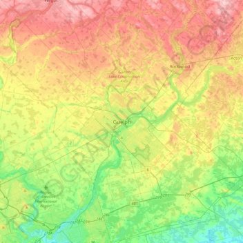
Nome: Mappa topografica Guelph, altitudine, rilievo.
Luogo: Guelph, Southwestern Ontario, Ontario, N1H 4E7, Canada (43.38605 -80.40933 43.70605 -80.08933)
Altitudine media: 344 m
Altitudine minima: 267 m
Altitudine massima: 440 m
Altre mappe topografiche
Clicca su una mappa per visualizzarne la topografia, l'altitudine e il rilievo.
The Arboretum
Victoria Woods is an old-growth hardwood forest made up of sugar maple, white ash, black cherry and beech. Varied topography in this area, which includes a pond, allows for a wide variety of woodland plants to grow here. Spring is an especially nice time to visit Victoria Woods to see many of these spring…
Altitudine media: 332 m
