
Mappa topografica Borough of Luton
Mappa interattiva
Clicca sulla mappa per visualizzare l'altitudine.
Borough of Luton
The local climate around Luton is differentiated somewhat from much of South East England due to its position in the Chiltern Hills, meaning it tends to be 1–2 degrees Celsius cooler than the surrounding towns – often flights at Luton airport, lying 160 m (525 ft) above sea level, will be suspended when marginal snow events occur, while airports at lower elevations, such as Heathrow, at 25 m (82 ft) above sea level, continue to function. An example of this is shown in the photograph to the right, the snowline being about 100 m (328 ft) above sea level. Absolute temperature extremes recorded at Rothamsted Research Station, 5 miles (8 km) south south east of Luton town centre and at a similar elevation range from −17.0 °C (1.4 °F) in December 1981 and −16.7 °C (1.9 °F) in January 1963 to 36.6 °C (97.9 °F) in July 2019 and 33.8 °C (92.8 °F) in August 1990 and July 2006. Records for Rothamsted date back to 1901.
A proposito di questa mappa
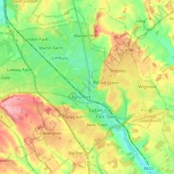
Nome: Mappa topografica Borough of Luton, altitudine, rilievo.
Luogo: Borough of Luton, England, United Kingdom (51.85447 -0.50595 51.92774 -0.34992)
Altitudine media: 146 m
Altitudine minima: 94 m
Altitudine massima: 215 m
Altre mappe topografiche
Clicca su una mappa per visualizzarne la topografia, l'altitudine e il rilievo.
Swindon
United Kingdom > England > Swindon
Swindon has an oceanic climate (Cfb in the Köppen climate classification), like the vast majority of the British Isles, with cool winters and warm summers. The nearest official weather station is RAF Lyneham, about 10 miles (16 km) west southwest of Swindon town centre. The weather station's elevation is 145…
Altitudine media: 108 m
Leeds
Lying in the eastern foothills of the Pennines, there is a significant variation in elevation within the city's built-up area. The district ranges from 1,115 feet (340 m) in the far west on the slopes of Ilkley Moor to about 33 feet (10 m) where the rivers Aire and Wharfe cross the eastern boundary. Land rises…
Altitudine media: 94 m
Portsmouth
United Kingdom > England > Hampshire > Portsmouth
By road, Portsmouth lies 73.5 miles (118.3 km) from Central London, 49.5 miles (79.7 km) west of Brighton, and 22.3 miles (35.9 km) east of Southampton. Portsmouth is situated primarily on Portsea Island and is the United Kingdom's only island city, although parts of it have expanded onto the mainland. Gosport…
Altitudine media: 28 m
Cambridge
United Kingdom > England > Cambridge
The city, like most of the UK, has a maritime climate highly influenced by the Gulf Stream. Located in the driest region of Britain, Cambridge's rainfall averages around 570 mm (22.44 in) per year, around half the national average, with some years occasionally falling into the semi-arid (under 500 mm (19.69…
Altitudine media: 18 m
Reading
United Kingdom > England > Reading
Mary Russell Mitford lived in Reading for a number of years and then spent the rest of her life just outside the town at Three Mile Cross and Swallowfield. The fictional Belford Regis of her eponymous novel, first published in 1835, is largely based on Reading. Described with topographical accuracy, it is…
Altitudine media: 56 m
Hull
United Kingdom > England > Kingston upon Hull
Kingston upon Hull is on the northern bank of the Humber Estuary. The city centre is west of the River Hull and close to the Humber. The city is built upon alluvial and glacial deposits which overlie chalk rocks but the underlying chalk has no influence on the topography. The land within the city is generally…
Altitudine media: 21 m
Crosby-on-Eden
United Kingdom > England > Cumberland > Low Crosby > High Crosby
Altitudine media: 22 m
St Albans
United Kingdom > England > Hertfordshire > St Albans
St Albans was an ancient borough created following the dissolution of the monastery in 1539. It consisted of the ancient parish of St Albans (also known as the Abbey parish) and parts of St Michael and St Peter. The municipal corporation was reformed by the Municipal Corporations Act 1835 and the boundary was…
Altitudine media: 100 m
Richmond
United Kingdom > England > London
The town centre lies just below 33 ft (10m) above sea level. South of the town centre, rising from Richmond Bridge to an elevation of 165 ft (50m), is Richmond Hill. Just beyond the summit of Richmond Hill is Richmond Park, an area of 2,360 acres (9.55 km2; 3.7 sq mi) of wild heath and woodland originally…
Altitudine media: 17 m
Ashby de la Zouch Canal
United Kingdom > England > Leicestershire > North West Leicestershire > Moira
Altitudine media: 100 m
Salisbury
United Kingdom > England > Salisbury
Bishop of Salisbury Hubert Walter was instrumental in the negotiations with Saladin during the Third Crusade, but he spent little time in his diocese prior to his elevation to archbishop of Canterbury. The brothers Herbert and Richard Poore succeeded him and began planning the relocation of the cathedral into…
Altitudine media: 96 m
Bedford
United Kingdom > England > Bedford
As with the rest of the United Kingdom, Bedford has a maritime climate, with a limited range of temperatures, and generally even rainfall throughout the year. The nearest Met Office weather station to Bedford is Bedford (Thurleigh) airport, about 6.5 miles (10.5 km) north of Bedford town centre at an elevation…
Altitudine media: 37 m
Plymouth
United Kingdom > England > Devon > Plymouth
The River Plym, which flows off Dartmoor to the north-east, forms a smaller estuary to the east of the city called Cattewater. Plymouth Sound is protected from the sea by the Plymouth Breakwater, in use since 1814. In the Sound is Drake's Island which is seen from Plymouth Hoe, a flat public area on top of…
Altitudine media: 81 m
Malvern
United Kingdom > England > Worcestershire > Malvern Hills
Malvern lies in the Lower Severn/Avon plain affording it a degree of shelter caused by virtue of its nestling in between the Cotswold hills to the east, the Welsh Hills and Mountains to the west, and Birmingham plateau to the north. Although as with all the British Isles it has a maritime climate, the local…
Altitudine media: 95 m
Worsbrough
United Kingdom > England > Barnsley
On High Street, Worsbrough Dale. The east elevation bears the inscriptions "AD 1903" and "Ebenezer Wesleyan Reform". There are also foundation stones either side of the doorway inscribed with "EBENEZER CHAPEL 1854". This suggests that the chapel was built in 1854 and extended upwards in 1903.
Altitudine media: 98 m
Peterborough
United Kingdom > England > Cambridgeshire
The local topography is flat, and in some places, the land lies below sea level, for example in parts of the Fens to the east and to the south of Peterborough. Human settlement in the area began before the Bronze Age, as can be seen at the Flag Fen archaeological site to the east of the current city centre,…
Altitudine media: 17 m
Miserden Estate
United Kingdom > England > Gloucestershire > Stroud > Miserden
Altitudine media: 218 m
Blackdown
United Kingdom > England > West Sussex > Chichester
Blackdown, or Black Down, summit elevation 279.7 metres (918 ft) AMSL, is the highest point in both the historic county of Sussex and the South Downs National Park. It is one of the highest points in the south east of England, exceeded by Walbury Hill, Leith Hill and Pilot Hill. Blackdown is protected as part…
Altitudine media: 165 m
Peterborough
United Kingdom > England > Cambridgeshire
The cathedral city of Ely is 24 miles (39 km) east-southeast across the Fens and the university city of Cambridge is 30 miles (48 km) to the southeast. The local topography is flat, and in places, the land lies below sea level.
Altitudine media: 17 m
Tottenham
Tottenham's elevation is approximately 33 ft (10 m) above sea level.
Altitudine media: 25 m
Halifax
United Kingdom > England > Calderdale
Topographically, Halifax is located in the south-eastern corner of the moorland region called the South Pennines. Halifax is situated about 4 miles (6 km) from the M62 motorway, close to Bradford and Huddersfield. The A641 road links the town with Brighouse, Bradford and Huddersfield. The Hebble Brook joins…
Altitudine media: 195 m