
Fai una donazione
Preparati per la tua prossima avventura:
In qualità di associato Amazon, questo sito riceve una commissione sugli acquisti idonei senza alcun costo aggiuntivo per te.
Mappa topografica Portsmouth
Clicca sulla mappa per visualizzare l'altitudine.
Fai una donazione
Preparati per la tua prossima avventura:
In qualità di associato Amazon, questo sito riceve una commissione sugli acquisti idonei senza alcun costo aggiuntivo per te.
Portsmouth
By road, Portsmouth lies 73.5 miles (118.3 km) from Central London, 49.5 miles (79.7 km) west of Brighton, and 22.3 miles (35.9 km) east of Southampton. Portsmouth is situated primarily on Portsea Island and is the United Kingdom's only island city, although parts of it have expanded onto the mainland. Gosport forms a borough in its own right immediately to the west. The island is separated from the mainland by Portsbridge Creek which is crossed by three road bridges (the M275 motorway, the A3 road, and the A2030 road), a railway bridge, and two footbridges. Portsea Island, which forms part of the Hampshire Basin, is low-lying: the majority of its surface area on the island is less than 3 metres (9.8 ft) above sea level. The highest natural elevation on Portsea Island is the road junction Kingston Cross, at 21 feet (6.4 m) above ordinary spring tide.
Fai una donazione
Preparati per la tua prossima avventura:
In qualità di associato Amazon, questo sito riceve una commissione sugli acquisti idonei senza alcun costo aggiuntivo per te.
A proposito di questa mappa
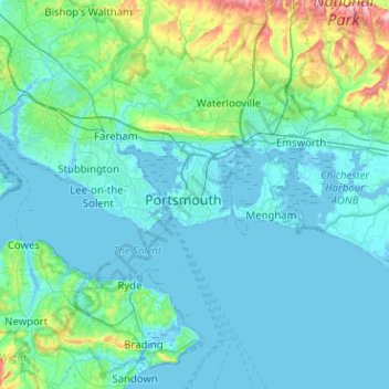
Nome: Mappa topografica Portsmouth, altitudine, rilievo.
Altitudine media: 28 m
Altitudine minima: -5 m
Altitudine massima: 236 m
Fai una donazione
Preparati per la tua prossima avventura:
In qualità di associato Amazon, questo sito riceve una commissione sugli acquisti idonei senza alcun costo aggiuntivo per te.
Altre mappe topografiche
Clicca su una mappa per visualizzarne la topografia, l'altitudine e il rilievo.