Geolocalizza

Mappa topografica Burghfield Common

Clicca sulla mappa per visualizzare l'altitudine.

👉 Easily get elevation data in JSON, GeoTIFF and KML formats using Elevation API
Grazie per il supporto a questo sito ❤️
Fai una donazione

Preparati per la tua prossima avventura:

In qualità di associato Amazon, questo sito riceve una commissione sugli acquisti idonei senza alcun costo aggiuntivo per te.

A proposito di questa mappa

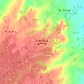
Nome: Mappa topografica Burghfield Common, altitudine, rilievo.

Luogo: Burghfield Common, West Berkshire, England, RG7 3ET, United Kingdom (51.37721 -1.08242 51.41721 -1.04242)

Altitudine media: 81 m

Altitudine minima: 42 m

Altitudine massima: 102 m

Altre mappe topografiche

Clicca su una mappa per visualizzarne la topografia, l'altitudine e il rilievo.

Newbury

United Kingdom > England > West Berkshire

Elevations vary from a minimum of 72 m above mean sea level to 122 m at Wash Common. Elevations reach 150–200 m in the directly adjoining hills. The River Kennet and the Kennet and Avon Canal flow east through the centre of the town to reach the Thames at Reading, while the River Lambourn (beside which is…

Altitudine media: 97 m

Hermitage

United Kingdom > England > West Berkshire

Altitudine media: 119 m

Chaddleworth

United Kingdom > England > West Berkshire

Altitudine media: 164 m

Pangbourne

United Kingdom > England > West Berkshire

Altitudine media: 64 m

Avington

United Kingdom > England > West Berkshire > Kintbury

Altitudine media: 104 m

Hungerford

United Kingdom > England > West Berkshire

Altitudine media: 131 m

Aldermaston

United Kingdom > England > West Berkshire

Altitudine media: 82 m

Streatley

United Kingdom > England > West Berkshire

Streatley is a village and civil parish on the River Thames in Berkshire, England. The village faces Goring-on-Thames. The two places share in their shops, services, leisure, sports and much of their transport. Across the river is Goring & Streatley railway station and the village cluster adjoins a lock and…

Altitudine media: 95 m

Beedon

United Kingdom > England > West Berkshire

Altitudine media: 160 m

Peasemore

United Kingdom > England > West Berkshire

Altitudine media: 155 m

East Ilsley

United Kingdom > England > West Berkshire

Altitudine media: 148 m

West Ilsley

United Kingdom > England > West Berkshire

Altitudine media: 161 m

Catmore

United Kingdom > England > West Berkshire

Altitudine media: 182 m

Brightwalton

United Kingdom > England > West Berkshire

Altitudine media: 178 m

Compton

United Kingdom > England > West Berkshire

Compton is buffered from neighbouring settlements by cultivated fields to all sides. The village is in a gently-sloped dry valley and the fledgling Pang seasonally enters from the north west and discharges in the south east and may be joined at the centre of the village by the Roden from the north, when winter…

Altitudine media: 137 m

East Garston

United Kingdom > England > West Berkshire

Altitudine media: 161 m

Greenham

United Kingdom > England > West Berkshire > Greenham

Altitudine media: 94 m

Combe

United Kingdom > England > West Berkshire

Altitudine media: 214 m

Fawley

United Kingdom > England > West Berkshire

Altitudine media: 175 m

Theale

United Kingdom > England > West Berkshire

Altitudine media: 49 m

Thatcham

United Kingdom > England > West Berkshire

Altitudine media: 94 m

River Kennet

United Kingdom > England > West Berkshire

Altitudine media: 119 m

Kintbury

United Kingdom > England > West Berkshire

Altitudine media: 121 m

Woolhampton

United Kingdom > England > West Berkshire

Altitudine media: 85 m

Winterbourne

United Kingdom > England > West Berkshire

Altitudine media: 120 m

Bradfield

United Kingdom > England > West Berkshire

Altitudine media: 77 m

Speen

United Kingdom > England > West Berkshire

Altitudine media: 106 m

Midgham

United Kingdom > England > West Berkshire

Altitudine media: 90 m

Welford

United Kingdom > England > West Berkshire

Altitudine media: 124 m

Yattendon

United Kingdom > England > West Berkshire

Altitudine media: 109 m

Beech Hill

United Kingdom > England > West Berkshire

Altitudine media: 56 m

Brimpton

United Kingdom > England > West Berkshire

Altitudine media: 77 m

Sulhamstead

United Kingdom > England > West Berkshire

Altitudine media: 69 m

Cold Ash

United Kingdom > England > West Berkshire

Altitudine media: 115 m

Englefield

United Kingdom > England > West Berkshire

Altitudine media: 57 m

Enborne

United Kingdom > England > West Berkshire

Altitudine media: 104 m

Ashampstead

United Kingdom > England > West Berkshire

Altitudine media: 123 m

Beenham

United Kingdom > England > West Berkshire > Beenham

Altitudine media: 77 m

West Woodhay

United Kingdom > England > West Berkshire

Altitudine media: 158 m

Inkpen

United Kingdom > England > West Berkshire > Inkpen

Altitudine media: 160 m

Chieveley

United Kingdom > England > West Berkshire

Altitudine media: 123 m

Boxford

United Kingdom > England > West Berkshire

Altitudine media: 123 m

Welford

United Kingdom > England > West Berkshire

Altitudine media: 124 m

Newbury

United Kingdom > England > West Berkshire

Elevations vary from a minimum of 72 m above mean sea level to 122 m at Wash Common. Elevations reach 150–200 m in the directly adjoining hills. The River Kennet and the Kennet and Avon Canal flow east through the centre of the town to reach the Thames at Reading, while the River Lambourn (beside which is…

Altitudine media: 97 m

Compton

United Kingdom > England > West Berkshire

Compton is buffered from neighbouring settlements by cultivated fields to all sides. The village is in a gently sloped dry valley and the fledgling Pang seasonally enters from the north west and discharges in the south east and may be joined at the centre of the village by the Roden from the north, when winter…

Altitudine media: 137 m

Newbury

United Kingdom > England > West Berkshire

Elevations vary from a minimum of 72 m above mean sea level to 122 m at Wash Common. Elevations reach 150–200 m in the directly adjoining hills. The River Kennet and the Kennet and Avon Canal flow east through the centre of the town to reach the Thames at Reading, while the River Lambourn (beside which is…

Altitudine media: 97 m

Thatcham

United Kingdom > England > West Berkshire

Altitudine media: 94 m

Hungerford

United Kingdom > England > West Berkshire

Altitudine media: 131 m

Welford

United Kingdom > England > West Berkshire

Altitudine media: 124 m

Preparati per la tua prossima avventura:

📷Action Camera - Videocamere resistenti per filmare discese in bici o scalate
👞Ghette da Neve - Protezioni per evitare che neve o fango entrino negli scarponi
🛌Sacchi a Pelo - Isolamento termico ottimale per dormire all'aperto anche a basse temperature
🔋Power Bank Solari - Caricabatterie solari per ricaricare smartphone e GPS in zone isolate
🩹Kit pronto soccorso - Essenziale per escursioni e viaggi

In qualità di associato Amazon, questo sito riceve una commissione sugli acquisti idonei senza alcun costo aggiuntivo per te.