
Mappa topografica Brightwalton
Clicca sulla mappa per visualizzare l'altitudine.
A proposito di questa mappa
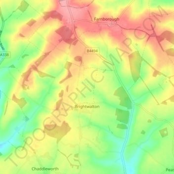
Nome: Mappa topografica Brightwalton, altitudine, rilievo.
Luogo: Brightwalton, West Berkshire, England, United Kingdom (51.49195 -1.42278 51.54212 -1.36271)
Altitudine media: 178 m
Altitudine minima: 124 m
Altitudine massima: 231 m
Altre mappe topografiche
Clicca su una mappa per visualizzarne la topografia, l'altitudine e il rilievo.
Walbury Hill
United Kingdom > England > West Berkshire > Combe
Walbury Hill is a summit of the North Wessex Downs in Berkshire, England. With an elevation of 297 metres (974 ft), it is the highest natural point in South East England. On the hill's summit is the Iron Age hill fort of Walbury Camp, whilst the flanks of the hill lie within the Inkpen and Walbury Hills SSSI.…
Altitudine media: 222 m
Aldermaston Wharf
United Kingdom > England > West Berkshire > Aldermaston Wharf
Altitudine media: 69 m
Leckhampstead Thicket
United Kingdom > England > West Berkshire > Leckhampstead
Altitudine media: 156 m