
Fai una donazione
Preparati per la tua prossima avventura:
In qualità di associato Amazon, questo sito riceve una commissione sugli acquisti idonei senza alcun costo aggiuntivo per te.
Mappa topografica Bath
Clicca sulla mappa per visualizzare l'altitudine.
Fai una donazione
Preparati per la tua prossima avventura:
In qualità di associato Amazon, questo sito riceve una commissione sugli acquisti idonei senza alcun costo aggiuntivo per te.
Bath
The floodplain of the Avon has an altitude of about 59 ft (18 m) above sea level, although the city centre is at an elevation of around 25 metres (82 ft) above sea level. The river, once an unnavigable series of braided streams broken up by swamps and ponds, has been managed by weirs into a single channel. Periodic flooding, which shortened the life of many buildings in the lowest part of the city, was normal until major flood control works were completed in the 1970s. Kensington Meadows is an area of mixed woodland and open meadow next to the river which has been designated as a local nature reserve.
Fai una donazione
Preparati per la tua prossima avventura:
In qualità di associato Amazon, questo sito riceve una commissione sugli acquisti idonei senza alcun costo aggiuntivo per te.
A proposito di questa mappa
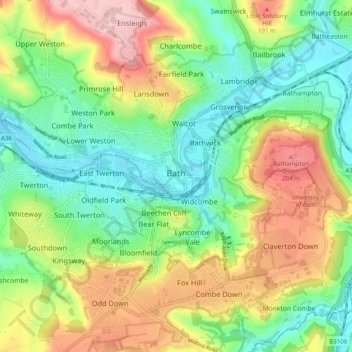
Nome: Mappa topografica Bath, altitudine, rilievo.
Altitudine media: 100 m
Altitudine minima: 14 m
Altitudine massima: 235 m
Fai una donazione
Preparati per la tua prossima avventura:
In qualità di associato Amazon, questo sito riceve una commissione sugli acquisti idonei senza alcun costo aggiuntivo per te.
Altre mappe topografiche
Clicca su una mappa per visualizzarne la topografia, l'altitudine e il rilievo.
Hallatrow
United Kingdom > England > Bath and North East Somerset > High Littleton
Altitudine media: 119 m
Norton Hawkfield
United Kingdom > England > Bath and North East Somerset > Norton Malreward
Altitudine media: 96 m
Fai una donazione
Preparati per la tua prossima avventura:
In qualità di associato Amazon, questo sito riceve una commissione sugli acquisti idonei senza alcun costo aggiuntivo per te.
Knowle Hill
United Kingdom > England > Bath and North East Somerset > Chew Magna
Altitudine media: 65 m
Little Solsbury Hill
United Kingdom > England > Bath and North East Somerset > Batheaston
Altitudine media: 88 m
Monger
United Kingdom > England > Bath and North East Somerset > Midsomer Norton
Altitudine media: 118 m
Bathwick Hill
United Kingdom > England > Bath and North East Somerset > Bath
Number 1 (Bathwick Lodge) is a 2-storey villa with a steep Mansard room, built in 1825, extended in 1840 and the late C19. Probably by John Pinch the Elder.[4] Number 2 is from the early 19th century and has shutters over the windows.[11] Number 3 includes a porch which is elaborately enriched with carving,…
Altitudine media: 93 m
Fai una donazione
Preparati per la tua prossima avventura:
In qualità di associato Amazon, questo sito riceve una commissione sugli acquisti idonei senza alcun costo aggiuntivo per te.
Chewton Keynsham
United Kingdom > England > Bath and North East Somerset > Compton Dando
Altitudine media: 57 m
North Wick
United Kingdom > England > Bath and North East Somerset > Chew Magna
Altitudine media: 110 m
Carlingcott
United Kingdom > England > Bath and North East Somerset > Peasedown St. John
Altitudine media: 123 m
Fai una donazione
Preparati per la tua prossima avventura:
In qualità di associato Amazon, questo sito riceve una commissione sugli acquisti idonei senza alcun costo aggiuntivo per te.
Pipehouse
United Kingdom > England > Bath and North East Somerset > Hinton Charterhouse
Altitudine media: 94 m
Fai una donazione
Preparati per la tua prossima avventura:
In qualità di associato Amazon, questo sito riceve una commissione sugli acquisti idonei senza alcun costo aggiuntivo per te.
Keynsham Memorial Park
United Kingdom > England > Bath and North East Somerset > Keynsham
Altitudine media: 29 m
Stoney Littleton
United Kingdom > England > Bath and North East Somerset > Shoscombe
Altitudine media: 116 m
Fai una donazione
Preparati per la tua prossima avventura:
In qualità di associato Amazon, questo sito riceve una commissione sugli acquisti idonei senza alcun costo aggiuntivo per te.
Clutton Hill
United Kingdom > England > Bath and North East Somerset > Farmborough
Altitudine media: 133 m
Fai una donazione
Preparati per la tua prossima avventura:
In qualità di associato Amazon, questo sito riceve una commissione sugli acquisti idonei senza alcun costo aggiuntivo per te.
Park Corner
United Kingdom > England > Bath and North East Somerset > Freshford > Park Corner
Altitudine media: 93 m
Wick Green
United Kingdom > England > Bath and North East Somerset > Bishop Sutton
Altitudine media: 82 m
Fai una donazione
Preparati per la tua prossima avventura:
In qualità di associato Amazon, questo sito riceve una commissione sugli acquisti idonei senza alcun costo aggiuntivo per te.
Maes Knoll
United Kingdom > England > Bath and North East Somerset > Norton Malreward
Altitudine media: 110 m
Whitley Batts
United Kingdom > England > Bath and North East Somerset > Pensford
Altitudine media: 87 m
Fai una donazione
Preparati per la tua prossima avventura:
In qualità di associato Amazon, questo sito riceve una commissione sugli acquisti idonei senza alcun costo aggiuntivo per te.