
Mappa topografica Bathwick Hill
Clicca sulla mappa per visualizzare l'altitudine.
Bathwick Hill
Number 1 (Bathwick Lodge) is a 2-storey villa with a steep Mansard room, built in 1825, extended in 1840 and the late C19. Probably by John Pinch the Elder.[4] Number 2 is from the early 19th century and has shutters over the windows.[11] Number 3 includes a porch which is elaborately enriched with carving, Neo-Grecian gate posts and wrought iron gates.[12] Number 4 has a parapet which sweeps up to central balustrade with a rococo flourish,[13] as does number 5 which is also known as Cornwall Lodge.[14] Number 6, which is also known as Willow House, includes a wrought iron verandah on the 1st floor. Number 7 has a shallow hipped roof.[15] Number 8 has also been known as Upsala Villa[16] and later as Mendip Lodge.[17] The road elevation of number 9, built in 1820, extended in 1870, presents half an octagon in plan with overhanging eaves.[18]
A proposito di questa mappa
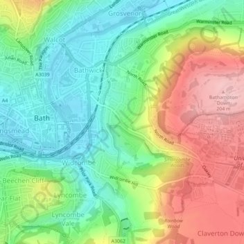
Nome: Mappa topografica Bathwick Hill, altitudine, rilievo.
Altitudine media: 93 m
Altitudine minima: 16 m
Altitudine massima: 208 m
Altre mappe topografiche
Clicca su una mappa per visualizzarne la topografia, l'altitudine e il rilievo.