
Mappa topografica Wiesmoor
Mappa interattiva
Clicca sulla mappa per visualizzare l'altitudine.
Wiesmoor
On Friday 13 January 1989, a half year after the Ramstein Airshow Disaster, there was a collision of several military jets at low altitude over the Hinrichsfehn area of Wiesmoor. A tornado of the Royal Air Force collided with a squadron of German Alphas Jets of the Jagdbombergeschwader 43 division. One of the German Alpha Jets was seriously damaged but managed to make an emergency landing, the a further Alpha Jet and the Tornado were destroyed, the pilot of the Alpha Jet managed to eject but the two pilots in the Tornado died in the accident. The wreckage from the jets landed near a primary school in South Wiesmoor.
A proposito di questa mappa
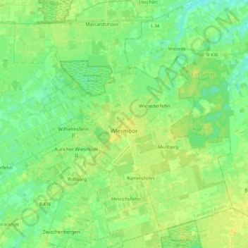
Nome: Mappa topografica Wiesmoor, altitudine, rilievo.
Luogo: Wiesmoor, Landkreis Aurich, Lower Saxony, 26639, Germany (53.35663 7.64467 53.47241 7.81582)
Altitudine media: 9 m
Altitudine minima: 0 m
Altitudine massima: 18 m
Altre mappe topografiche
Clicca su una mappa per visualizzarne la topografia, l'altitudine e il rilievo.