
Fai una donazione
Preparati per la tua prossima avventura:
In qualità di associato Amazon, questo sito riceve una commissione sugli acquisti idonei senza alcun costo aggiuntivo per te.
Mappa topografica Greetsiel
Clicca sulla mappa per visualizzare l'altitudine.
Fai una donazione
Preparati per la tua prossima avventura:
In qualità di associato Amazon, questo sito riceve una commissione sugli acquisti idonei senza alcun costo aggiuntivo per te.
A proposito di questa mappa
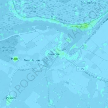
Nome: Mappa topografica Greetsiel, altitudine, rilievo.
Altitudine media: -1 m
Altitudine minima: -5 m
Altitudine massima: 6 m
Fai una donazione
Preparati per la tua prossima avventura:
In qualità di associato Amazon, questo sito riceve una commissione sugli acquisti idonei senza alcun costo aggiuntivo per te.
Altre mappe topografiche
Clicca su una mappa per visualizzarne la topografia, l'altitudine e il rilievo.
Fai una donazione
Preparati per la tua prossima avventura:
In qualità di associato Amazon, questo sito riceve una commissione sugli acquisti idonei senza alcun costo aggiuntivo per te.
Juist
Germany > Lower Saxony > Landkreis Aurich
Juist is accessible by plane or daily ferry. FLN Frisia Luftverkehr operates planes between Norden and Juist. Most motor vehicles are prohibited on the island, with only the fire department, the German Red Cross and doctors allowed to use them. Island tractors require a special license, while most other…
Altitudine media: 0 m
Wiesmoor
Germany > Lower Saxony > Landkreis Aurich
On Friday 13 January 1989, a half year after the Ramstein Airshow Disaster, there was a collision of several military jets at low altitude over the Hinrichsfehn area of Wiesmoor. A tornado of the Royal Air Force collided with a squadron of German Alphas Jets of the Jagdbombergeschwader 43 division. One of the…
Altitudine media: 9 m
Fai una donazione
Preparati per la tua prossima avventura:
In qualità di associato Amazon, questo sito riceve una commissione sugli acquisti idonei senza alcun costo aggiuntivo per te.
Juist
Germany > Lower Saxony > Landkreis Aurich
Juist is accessible by plane or daily ferry. FLN Frisia Luftverkehr operates planes between Norden and Juist. Most motor vehicles are prohibited on the island, with only the fire department, the German Red Cross and doctors allowed to use them. Island tractors require a special license, while most other…
Altitudine media: 0 m
Fai una donazione
Preparati per la tua prossima avventura:
In qualità di associato Amazon, questo sito riceve una commissione sugli acquisti idonei senza alcun costo aggiuntivo per te.
Fai una donazione
Preparati per la tua prossima avventura:
In qualità di associato Amazon, questo sito riceve una commissione sugli acquisti idonei senza alcun costo aggiuntivo per te.