
Fai una donazione
Preparati per la tua prossima avventura:
In qualità di associato Amazon, questo sito riceve una commissione sugli acquisti idonei senza alcun costo aggiuntivo per te.
Mappa topografica Tekoa Mountain
Clicca sulla mappa per visualizzare l'altitudine.
Fai una donazione
Preparati per la tua prossima avventura:
In qualità di associato Amazon, questo sito riceve una commissione sugli acquisti idonei senza alcun costo aggiuntivo per te.
Tekoa Mountain
Tekoa Mountain overlooks the Westfield River Gorge and the Connecticut River Valley. The town of Russell and its villages, Woronoco and Crescent Mills, lie at the foot of the mountain along the Westfield River. From the summit ledges, the cities of Westfield and Springfield, Massachusetts are visible to the east. The southwest and northeast sides of Tekoa Mountain are steep and rugged with frequent cliff faces and rocky overlooks; to the north, the topography gradually flattens out as Tekoa Mountain merges with the upland plateau of Montgomery. The southwest side of Tekoa Mountain drains into the Westfield River, thence into the Connecticut River and Long Island Sound; the northeast side drains into Moose Meadow Brook, thence the Westfield River.
Fai una donazione
Preparati per la tua prossima avventura:
In qualità di associato Amazon, questo sito riceve una commissione sugli acquisti idonei senza alcun costo aggiuntivo per te.
A proposito di questa mappa
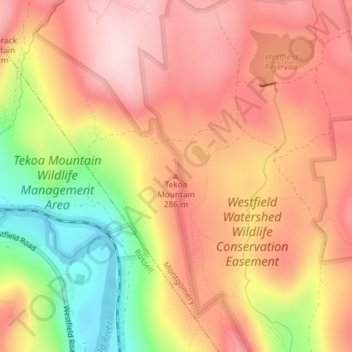
Nome: Mappa topografica Tekoa Mountain, altitudine, rilievo.
Altitudine media: 241 m
Altitudine minima: 65 m
Altitudine massima: 351 m
Fai una donazione
Preparati per la tua prossima avventura:
In qualità di associato Amazon, questo sito riceve una commissione sugli acquisti idonei senza alcun costo aggiuntivo per te.