
Fai una donazione
Preparati per la tua prossima avventura:
In qualità di associato Amazon, questo sito riceve una commissione sugli acquisti idonei senza alcun costo aggiuntivo per te.
Mappa topografica South Lhonak Glacier
Clicca sulla mappa per visualizzare l'altitudine.
Fai una donazione
Preparati per la tua prossima avventura:
In qualità di associato Amazon, questo sito riceve una commissione sugli acquisti idonei senza alcun costo aggiuntivo per te.
A proposito di questa mappa
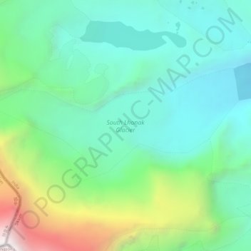
Nome: Mappa topografica South Lhonak Glacier, altitudine, rilievo.
Altitudine media: 5.830 m
Altitudine minima: 5.225 m
Altitudine massima: 7.457 m
Fai una donazione
Preparati per la tua prossima avventura:
In qualità di associato Amazon, questo sito riceve una commissione sugli acquisti idonei senza alcun costo aggiuntivo per te.
Altre mappe topografiche
Clicca su una mappa per visualizzarne la topografia, l'altitudine e il rilievo.
Kangchenjunga
India > Sikkim > Chungthang
Kangchenjunga Main is the highest elevation of the Brahmaputra River basin, which forms part of the southeast Asian monsoon regime and is among the globally largest river basins. Kangchenjunga is one of six peaks above 8,000 m (26,000 ft) located in the basin of the Kosi River, which is among the largest…
Altitudine media: 7.725 m
Fai una donazione
Preparati per la tua prossima avventura:
In qualità di associato Amazon, questo sito riceve una commissione sugli acquisti idonei senza alcun costo aggiuntivo per te.
Kangchenjunga
India > Sikkim > Chungthang
Kangchenjunga Main is the highest elevation of the Brahmaputra River basin, which forms part of the southeast Asian monsoon regime and is among the globally largest river basins. Kangchenjunga is one of six peaks above 8,000 m (26,000 ft) located in the basin of the Kosi River, which is among the largest…
Altitudine media: 7.725 m
Fai una donazione
Preparati per la tua prossima avventura:
In qualità di associato Amazon, questo sito riceve una commissione sugli acquisti idonei senza alcun costo aggiuntivo per te.
Lachung
India > Sikkim > Chungthang
Lachung is a town and hill station in northeast Sikkim, India. It is located in the North Sikkim district near the border with Tibet. Lachung is at an elevation of about 9,600 feet (2,900 m) and at the confluence of the Lachen and Lachung Rivers, both tributaries of the River Teesta. The word Lachung means…
Altitudine media: 3.617 m