
Mappa topografica Chaskaman
Clicca sulla mappa per visualizzare l'altitudine.
A proposito di questa mappa
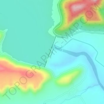
Nome: Mappa topografica Chaskaman, altitudine, rilievo.
Luogo: Chaskaman, Khed, Pune District, Maharashtra, 410513, India (18.95517 73.78323 18.96353 73.78649)
Altitudine media: 669 m
Altitudine minima: 608 m
Altitudine massima: 821 m
Altre mappe topografiche
Clicca su una mappa per visualizzarne la topografia, l'altitudine e il rilievo.
Alandi
India > Maharashtra > Khed
Alandi (18°40′37.42″N 73°53′47.76″E / 18.6770611°N 73.8966000°E / 18.6770611; 73.8966000) is located on the bank of the Indrayani River, 18.8 km (11.7 mi) from Khed Taluka of Pune District, near the northern edge of the city of Pune. Alandi has an average elevation of 577 meters (1,893 feet).
Altitudine media: 578 m
Chakan
India > Maharashtra > Khed
Shiroli Chandus village, located 6 km north of Chakan, had been identified as the probable site for the proposed Pune International Airport, but due to the protests by the villagers & uneven topography, the site has been shifted to Purandar.
Altitudine media: 624 m
Alandi
India > Maharashtra > Khed
Alandi (18°40′37.42″N 73°53′47.76″E / 18.6770611°N 73.8966000°E / 18.6770611; 73.8966000) is located on the bank of the Indrayani River, 18.8 km (11.7 mi) from Khed Taluka of Pune District, near the northern edge of the city of Pune. Alandi has an average elevation of 577 meters (1,893 feet).
Altitudine media: 578 m