Mappa topografica Raleigh
Clicca sulla mappa per visualizzare l'altitudine.
Raleigh
Raleigh features a topography primarily defined by its position along the fall line, which is the geological boundary between the Piedmont and Coastal Plain regions. This area experiences a gradual elevation drop of approximately 150 to 350 feet over a distance of 1 to 3 miles as one moves eastward. The city's landscape is characterized by rolling hills, interspersed with various waterways, including the Neuse River, which flows through the region. The surrounding terrain includes a mixture of woodlands and urban development, with dense forests of pines and deciduous trees prevalent in the area. Overall, Raleigh's topography contributes to its diverse ecosystems and recreational opportunities, making it a significant part of the Research Triangle region, known for its natural beauty and outdoor activities.
A proposito di questa mappa
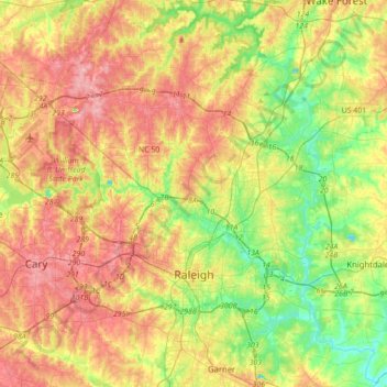
Nome: Mappa topografica Raleigh, altitudine, rilievo.
Luogo: Raleigh, Wake County, North Carolina, United States (35.70826 -78.81897 35.97074 -78.47079)
Altitudine media: 103 m
Altitudine minima: 44 m
Altitudine massima: 167 m
Altre mappe topografiche
Clicca su una mappa per visualizzarne la topografia, l'altitudine e il rilievo.


Harris Lake County Park
United States > North Carolina > Wake County > Hollemans Crossroads
Altitudine media: 75 m
Lake Johnson
United States > North Carolina > Wake County > Raleigh > Orchards
Altitudine media: 121 m
Prestonwood Soccer Complex
United States > North Carolina > Wake County > Cary
Altitudine media: 111 m
Lake Raleigh
United States > North Carolina > Wake County > Raleigh > Isle Forest
Altitudine media: 104 m