
Fai una donazione
Preparati per la tua prossima avventura:
In qualità di associato Amazon, questo sito riceve una commissione sugli acquisti idonei senza alcun costo aggiuntivo per te.
Mappa topografica Yukon
Clicca sulla mappa per visualizzare l'altitudine.
Fai una donazione
Preparati per la tua prossima avventura:
In qualità di associato Amazon, questo sito riceve una commissione sugli acquisti idonei senza alcun costo aggiuntivo per te.
A proposito di questa mappa
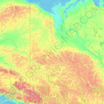
Nome: Mappa topografica Yukon, altitudine, rilievo.
Luogo: Yukon, Canada (59.99854 -141.00275 69.84588 -123.81025)
Altitudine media: 723 m
Altitudine minima: -3 m
Altitudine massima: 5.610 m
Fai una donazione
Preparati per la tua prossima avventura:
In qualità di associato Amazon, questo sito riceve una commissione sugli acquisti idonei senza alcun costo aggiuntivo per te.
Altre mappe topografiche
Clicca su una mappa per visualizzarne la topografia, l'altitudine e il rilievo.
Toronto
Despite its deep ravines, Toronto is not remarkably hilly, but its elevation does increase steadily away from the lake. Elevation differences range from 76.5 metres (251 ft) above sea level at the Lake Ontario shore to 209 m (686 ft) ASL near the York University grounds in the city's north end at the…
Altitudine media: 113 m
Fai una donazione
Preparati per la tua prossima avventura:
In qualità di associato Amazon, questo sito riceve una commissione sugli acquisti idonei senza alcun costo aggiuntivo per te.
Peterborough
Canada > Ontario > Peterborough
Peterborough's topography is largely defined by land formations created by the receding Wisconsian glaciers 10,000–15,000 years ago. The South End and Downtown portions of the City sit on what was the bottom of the glacial Lake Peterborough—part of a glacial spillway created when glacial meltwaters from…
Altitudine media: 235 m
Fai una donazione
Preparati per la tua prossima avventura:
In qualità di associato Amazon, questo sito riceve una commissione sugli acquisti idonei senza alcun costo aggiuntivo per te.
Guelph
This region of Ontario has cold winters and warm, humid summers, falling into the Köppen climate classification Dfb zone, with moderately high rainfall and snowfall. It is generally a couple of degrees cooler than lower elevation regions on the Great Lakes shorelines, especially so in winter, the exception…
Altitudine media: 344 m
Banff
Canada > Alberta > Banff > Banff
Banff is a town within Banff National Park in Alberta, Canada. It is located in Alberta's Rockies along the Trans-Canada Highway, approximately 126 km (78 mi) west of Calgary and 58 km (36 mi) east of Lake Louise. At 1,400 to 1,630 m (4,590 to 5,350 ft) above sea level, Banff is the community with the second…
Altitudine media: 1.615 m
Fai una donazione
Preparati per la tua prossima avventura:
In qualità di associato Amazon, questo sito riceve una commissione sugli acquisti idonei senza alcun costo aggiuntivo per te.
Lethbridge
Canada > Alberta > Lethbridge
Its high elevation of 929 m (3,047.9 ft) and close proximity to the Rocky Mountains provides Lethbridge with cooler summers than other locations in the Canadian Prairies. These factors protect the city from strong northwest and southwest winds and contribute to frequent chinook winds during the winter.…
Altitudine media: 918 m
Fai una donazione
Preparati per la tua prossima avventura:
In qualità di associato Amazon, questo sito riceve una commissione sugli acquisti idonei senza alcun costo aggiuntivo per te.
Fai una donazione
Preparati per la tua prossima avventura:
In qualità di associato Amazon, questo sito riceve una commissione sugli acquisti idonei senza alcun costo aggiuntivo per te.
Fairmont Hot Springs
Canada > British Columbia > Regional District of East Kootenay > Area F (Columbia Lake/Windermere Lake)
Altitudine media: 920 m
London
Canada > Ontario > London > London
London has a humid continental climate (Köppen Dfb), though due to its downwind location relative to Lake Huron and elevation changes across the city, it is virtually on the Dfa/Dfb (hot summer) boundary favouring the former climate zone to the southwest of the confluence of the South and North Thames Rivers,…
Altitudine media: 268 m
Fai una donazione
Preparati per la tua prossima avventura:
In qualità di associato Amazon, questo sito riceve una commissione sugli acquisti idonei senza alcun costo aggiuntivo per te.
Bowsman
Canada > Manitoba > Division No. 20 > Rural Municipality of Minitonas – Bowsman
Altitudine media: 310 m
Fai una donazione
Preparati per la tua prossima avventura:
In qualità di associato Amazon, questo sito riceve una commissione sugli acquisti idonei senza alcun costo aggiuntivo per te.
Lake Louise
Canada > Alberta > Improvement District No. 9
Lake Louise is a hamlet within Banff National Park in Alberta, Canada. Named after Princess Louise, Duchess of Argyll, it lies in Alberta's Rockies on the Bow River, 3 km (1.9 mi) northeast of the lake that shares its name. Initially settled in 1884 as an outpost for the Canadian Pacific Railway, Lake Louise…
Altitudine media: 1.617 m
Coquitlam
Canada > British Columbia > Metro Vancouver Regional District > Coquitlam
Southwest Coquitlam comprises the original core of the city, with Maillardville and Fraser River industrial sector giving way to the large residential areas of Austin Heights, colloquially referred to as "The Bump" due to its high and flat plateau topography. These older residences, with larger property…
Altitudine media: 230 m
Winnipeg
Canada > Manitoba > Winnipeg > Winnipeg
Winnipeg lies at the bottom of the Red River Valley, a flood plain with an extremely flat topography. It is on the eastern edge of the Canadian Prairies in Western Canada and is known as the "Gateway to the West". Winnipeg is bordered by tallgrass prairie to the west and south and the aspen parkland to the…
Altitudine media: 236 m
Fai una donazione
Preparati per la tua prossima avventura:
In qualità di associato Amazon, questo sito riceve una commissione sugli acquisti idonei senza alcun costo aggiuntivo per te.
Seeleys Bay
Canada > Ontario > Leeds and Grenville Counties > Leeds and the Thousand Islands > Seeley's Bay
Altitudine media: 105 m
Fai una donazione
Preparati per la tua prossima avventura:
In qualità di associato Amazon, questo sito riceve una commissione sugli acquisti idonei senza alcun costo aggiuntivo per te.
Fai una donazione
Preparati per la tua prossima avventura:
In qualità di associato Amazon, questo sito riceve una commissione sugli acquisti idonei senza alcun costo aggiuntivo per te.
Fai una donazione
Preparati per la tua prossima avventura:
In qualità di associato Amazon, questo sito riceve una commissione sugli acquisti idonei senza alcun costo aggiuntivo per te.
Fai una donazione
Preparati per la tua prossima avventura:
In qualità di associato Amazon, questo sito riceve una commissione sugli acquisti idonei senza alcun costo aggiuntivo per te.
Thompson River
Canada > British Columbia > Thompson-Nicola Regional District
Altitudine media: 1.127 m
Cawston
Canada > British Columbia > Regional District of Okanagan-Similkameen > Area B (Cawston/Lower Similkameen)
Altitudine media: 410 m
Fai una donazione
Preparati per la tua prossima avventura:
In qualità di associato Amazon, questo sito riceve una commissione sugli acquisti idonei senza alcun costo aggiuntivo per te.
Fai una donazione
Preparati per la tua prossima avventura:
In qualità di associato Amazon, questo sito riceve una commissione sugli acquisti idonei senza alcun costo aggiuntivo per te.
Fai una donazione
Preparati per la tua prossima avventura:
In qualità di associato Amazon, questo sito riceve una commissione sugli acquisti idonei senza alcun costo aggiuntivo per te.
Whistler
Canada > British Columbia > Squamish-Lillooet Regional District > Whistler Resort Municipality > Whistler
Altitudine media: 996 m
Fai una donazione
Preparati per la tua prossima avventura:
In qualità di associato Amazon, questo sito riceve una commissione sugli acquisti idonei senza alcun costo aggiuntivo per te.
Quebec
Canada > Quebec > Urban agglomeration of Québec
Quebec City was built on the north bank of the Saint Lawrence River, where it narrows and meets the mouth of the Saint-Charles River. Old Quebec is located on top and at the foot of Cap-Diamant, which is on the eastern edge of a plateau called the promontory of Quebec (Quebec hill). Because of this topographic…
Altitudine media: 100 m
Laurentian Mountains
One of Quebec's official regions is called Laurentides. The mountain range runs through four other regions; Capitale-Nationale, Outaouais, Lanaudière, and Mauricie. The elevation generally ranges from around 500 m (1,640 ft) to 1,000 m (3,280 ft) with Mont Raoul-Blanchard being its highest peak, at 1,166 m…
Altitudine media: 348 m
Fai una donazione
Preparati per la tua prossima avventura:
In qualità di associato Amazon, questo sito riceve una commissione sugli acquisti idonei senza alcun costo aggiuntivo per te.
Mount Washington
Canada > British Columbia > Comox Valley Regional District > Area C (Puntledge/Black Creek)
Altitudine media: 1.279 m
Fai una donazione
Preparati per la tua prossima avventura:
In qualità di associato Amazon, questo sito riceve una commissione sugli acquisti idonei senza alcun costo aggiuntivo per te.
Fai una donazione
Preparati per la tua prossima avventura:
In qualità di associato Amazon, questo sito riceve una commissione sugli acquisti idonei senza alcun costo aggiuntivo per te.
Cochrane
Canada > Alberta > Town of Cochrane > Cochrane
Cochrane is situated at the base of Big Hill in the Bow River Valley. It sits at an elevation of 1,186 m (3,891 ft). The town is intersected by Highway 1A and Highway 22. Cochrane has a reputation for its western culture, which can easily be felt when one wanders the streets (particularly Main Street). The…
Altitudine media: 1.205 m
Grande Prairie
Canada > Alberta > Grande Prairie
Grande Prairie is located just north of the 55th parallel north, and is 465 km (289 mi) northwest of Edmonton, lying at an elevation of 669 m (2,195 ft) above sea level. The city is surrounded by farmland to the north, east, and west. To the south lies a vast boreal forest with aspen, tamarack, lodgepole pine,…
Altitudine media: 668 m
Fai una donazione
Preparati per la tua prossima avventura:
In qualità di associato Amazon, questo sito riceve una commissione sugli acquisti idonei senza alcun costo aggiuntivo per te.
Kamloops
Canada > British Columbia > Thompson-Nicola Regional District > Kamloops
Altitudine media: 875 m
Fai una donazione
Preparati per la tua prossima avventura:
In qualità di associato Amazon, questo sito riceve una commissione sugli acquisti idonei senza alcun costo aggiuntivo per te.
Fai una donazione
Preparati per la tua prossima avventura:
In qualità di associato Amazon, questo sito riceve una commissione sugli acquisti idonei senza alcun costo aggiuntivo per te.
Stanley Park
Canada > British Columbia > Metro Vancouver Regional District > Vancouver
Altitudine media: 14 m
Fai una donazione
Preparati per la tua prossima avventura:
In qualità di associato Amazon, questo sito riceve una commissione sugli acquisti idonei senza alcun costo aggiuntivo per te.
Annapolis Valley
Canada > Nova Scotia > Municipality of the County of Kings > Auburn
Altitudine media: 77 m
Fai una donazione
Preparati per la tua prossima avventura:
In qualità di associato Amazon, questo sito riceve una commissione sugli acquisti idonei senza alcun costo aggiuntivo per te.
Canmore
Canada > Alberta > Town of Canmore
Elevation Place opened in April 2013 as Canmore's new recreation facility. Construction of the facility began in 2012 to replace the Canmore Recreation Centre (the community's old facility). The facility offers an 8-lane 25m lap pool, a world class climbing wall developed by Walltopia, two cardio rooms, a…
Altitudine media: 1.565 m
Nova Scotia peninsula
Canada > Nova Scotia > Hants County > Upper Rawdon
The Cobequid Mountains contain the highest elevation points on the peninsula. This low, heavily eroded part of the Appalachian Mountains, along with the Pictou-Antigonish Highlands, comprises a highland across the northern portion of the peninsula with average elevations between 250–300 metres. It was…
Altitudine media: 118 m
Mount Royal
Canada > Quebec > Urban agglomeration of Montreal > Montreal
The hill is part of the Monteregian Hills situated between the Laurentians and the Appalachian Mountains. It gave its Latin name, Mons Regius, to the Monteregian chain. The hill consists of three peaks: Colline de la Croix (or Mont Royal proper) at 233 m (764 ft), Colline d'Outremont (or Mount Murray, in the…
Altitudine media: 111 m
Fai una donazione
Preparati per la tua prossima avventura:
In qualità di associato Amazon, questo sito riceve una commissione sugli acquisti idonei senza alcun costo aggiuntivo per te.