
Mappa topografica Bramshall
Clicca sulla mappa per visualizzare l'altitudine.
A proposito di questa mappa
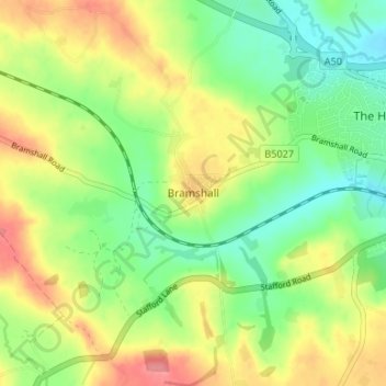
Nome: Mappa topografica Bramshall, altitudine, rilievo.
Altitudine media: 121 m
Altitudine minima: 86 m
Altitudine massima: 165 m
Altre mappe topografiche
Clicca su una mappa per visualizzarne la topografia, l'altitudine e il rilievo.
Tutbury Castle
United Kingdom > England > Staffordshire > East Staffordshire > Tutbury
Altitudine media: 66 m
Barton-under-Needwood
United Kingdom > England > Staffordshire > East Staffordshire > Barton-under-Needwood
Altitudine media: 69 m
Draycott in the Clay
United Kingdom > England > Staffordshire > East Staffordshire
Altitudine media: 90 m
Blithfield Reservoir
United Kingdom > England > Staffordshire > East Staffordshire > Admaston
Altitudine media: 108 m
Shobnall
United Kingdom > England > Staffordshire > East Staffordshire > Burton-on-Trent
Altitudine media: 56 m
Mayfield
United Kingdom > England > Staffordshire > East Staffordshire > Mayfield
Altitudine media: 156 m
Hanbury
United Kingdom > England > Staffordshire > East Staffordshire
This locality adjoins the River Dove and includes a steep knoll between much of it and the river, Row Hill; five listed buildings are here all at Grade II. Hanbury's village centre is 0.9 miles (1.4 km) to the south. This hamlet is at an elevation of 61m AOD whereas the village centre of Hanbury is at the…
Altitudine media: 107 m
Harlow Wood
United Kingdom > England > Staffordshire > East Staffordshire > Upper Mayfield
Altitudine media: 177 m