Geolocalizza

Mappa topografica Barton-under-Needwood

Clicca sulla mappa per visualizzare l'altitudine.

A proposito di questa mappa

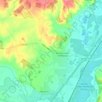
Nome: Mappa topografica Barton-under-Needwood, altitudine, rilievo.

Luogo: Barton-under-Needwood, East Staffordshire, Staffordshire, England, United Kingdom (52.74096 -1.77929 52.79127 -1.68253)

Altitudine media: 69 m

Altitudine minima: 42 m

Altitudine massima: 126 m

Altre mappe topografiche

Clicca su una mappa per visualizzarne la topografia, l'altitudine e il rilievo.

Burton upon Trent

United Kingdom > England > Staffordshire > East Staffordshire

Burton is about 109 miles (175 km) north west of London, about 30 miles north east of Birmingham, the UK's second largest city and about 23 miles east of the county town Stafford. It is at the easternmost border of the county of Staffordshire with Derbyshire, its suburbs and the course of the River Trent…

Altitudine media: 69 m

Preparati per la tua prossima avventura:

🦟Spray Insetti - Protezione efficace contro zanzare e zecche nei boschi
Tende da Campeggio - Tende compatte e facili da montare per bivacchi in alta montagna
🥾Scarponi da trekking donna - Comfort e stabilità per lunghe camminate su terreni irregolari
🧴Creme Anti-Sfregamento - Per prevenire irritazioni cutanee durante lunghe marce
🌧️Poncho antipioggia - Protezione leggera contro la pioggia

In qualità di associato Amazon, questo sito riceve una commissione sugli acquisti idonei senza alcun costo aggiuntivo per te.