Geolocalizza
👉 Easily get elevation data in JSON, GeoTIFF and KML formats using Elevation API
Grazie per il supporto a questo sito ❤️
Fai una donazione

Preparati per la tua prossima avventura:

In qualità di associato Amazon, questo sito riceve una commissione sugli acquisti idonei senza alcun costo aggiuntivo per te.

Mappa topografica Lightwater

Clicca sulla mappa per visualizzare l'altitudine.

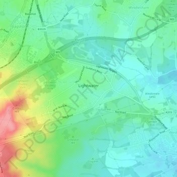
A proposito di questa mappa

Nome: Mappa topografica Lightwater, altitudine, rilievo.

Luogo: Lightwater, Windlesham, Surrey Heath, Surrey, England, United Kingdom (51.33902 -0.70422 51.35867 -0.64820)

Altitudine media: 62 m

Altitudine minima: 35 m

Altitudine massima: 130 m

Altre mappe topografiche

Clicca su una mappa per visualizzarne la topografia, l'altitudine e il rilievo.

Camberley

United Kingdom > England > Surrey > Surrey Heath

The Staff College, to the north of Camberley town centre, is part of the Joint Services Command and Staff College, which provides training and education for established officers in the British Armed Forces and civil servants in the Ministry of Defence. The institution has its origins in the Royal Military…

Altitudine media: 88 m

Bagshot

United Kingdom > England > Surrey > Surrey Heath

Altitudine media: 80 m

Frimley

United Kingdom > England > Surrey > Surrey Heath

Altitudine media: 82 m

Mytchett

United Kingdom > England > Surrey > Surrey Heath

Altitudine media: 82 m

Camberley

United Kingdom > England > Surrey > Surrey Heath

The Staff College, to the north of Camberley town centre, is part of the Joint Services Command and Staff College, which provides training and education for established officers in the British Armed Forces and civil servants in the Ministry of Defence. The institution has its origins in the Royal Military…

Altitudine media: 88 m

Frimley

United Kingdom > England > Surrey > Surrey Heath

Altitudine media: 82 m

North Bourne

United Kingdom > England > Surrey > Surrey Heath > Chobham

Altitudine media: 33 m

Valley End

United Kingdom > England > Surrey > Surrey Heath

Altitudine media: 56 m

Mimbridge

United Kingdom > England > Surrey > Surrey Heath > Chobham

Altitudine media: 26 m

Bagshot

United Kingdom > England > Surrey > Surrey Heath

Altitudine media: 80 m

Frimley Green

United Kingdom > England > Surrey > Surrey Heath

Altitudine media: 82 m

Stonehill

United Kingdom > England > Surrey > Surrey Heath

Altitudine media: 40 m

Preparati per la tua prossima avventura:

👕Abbigliamento Termico - Maglie intime tecniche per la gestione del calore corporeo
Orologi con Altimetro - Smartwatch con GPS, barometro e mappe integrate per sport estremi
📻Walkie Talkie - Comunicazione radio affidabile dove non c'è campo cellulare
🩹Kit Primo Soccorso - Set medico compatto con tutto l'essenziale per emergenze outdoor
🎒Zaini da escursionismo - Capienti e comodi per camminate e trekking

In qualità di associato Amazon, questo sito riceve una commissione sugli acquisti idonei senza alcun costo aggiuntivo per te.