
Mappa topografica Bagshot
Clicca sulla mappa per visualizzare l'altitudine.
A proposito di questa mappa
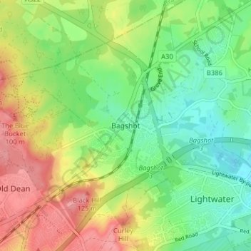
Nome: Mappa topografica Bagshot, altitudine, rilievo.
Altitudine media: 80 m
Altitudine minima: 42 m
Altitudine massima: 132 m
Altre mappe topografiche
Clicca su una mappa per visualizzarne la topografia, l'altitudine e il rilievo.
Bagshot Park Mansion
United Kingdom > England > Surrey > Surrey Heath > Bagshot
Altitudine media: 76 m
Chobham Common
United Kingdom > England > Surrey > Surrey Heath > Chobham > Brick Hill
Altitudine media: 49 m
Frimley Lodge Park
United Kingdom > England > Surrey > Surrey Heath > Frimley Green
Altitudine media: 80 m
Chobham
United Kingdom > England > Surrey > Surrey Heath
The rolling basin below reaches lowest elevations of between 30 metres (98 ft) in the centre of the west and 20 metres (66 ft) where the rivers join in the centre of the east. The rivers at the western point are less than 100 metres (330 ft) apart; to the east end of the parish where the parish adjoins the…
Altitudine media: 43 m