
Mappa topografica Buckskin Joe
Clicca sulla mappa per visualizzare l'altitudine.
A proposito di questa mappa
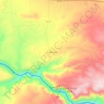
Nome: Mappa topografica Buckskin Joe, altitudine, rilievo.
Luogo: Buckskin Joe, Fremont County, Colorado, United States (38.45639 -105.34694 38.49639 -105.30694)
Altitudine media: 1.919 m
Altitudine minima: 1.679 m
Altitudine massima: 2.085 m
Altre mappe topografiche
Clicca su una mappa per visualizzarne la topografia, l'altitudine e il rilievo.
Cañon City
United States > Colorado > Fremont County
The city's nickname, "the Climate Capital of Colorado", derives from the combination of unique geography and 5,300-foot (1,600 m) elevation protecting the city from harsh weather conditions. The average daily high temperature in January is 14 °F (7.8 °C) warmer in Cañon City than in Grand Junction, even…
Altitudine media: 1.723 m
Cañon City
United States > Colorado > Fremont County
Cañon City is located in eastern Fremont County at 38°26′48″N 105°13′42″W / 38.44667°N 105.22833°W / 38.44667; -105.22833 (38.446800, -105.228305) at an altitude of 5,332 feet (1,625 m). It sits primarily on the north side of the Arkansas River, just east of where the river exits from…
Altitudine media: 1.723 m
Cañon City
United States > Colorado > Fremont County
The city's nickname, "the Climate Capital of Colorado", derives from the combination of unique geography and 5,300-foot (1,600 m) elevation protecting the city from harsh weather conditions. The average daily high temperature in January is 14 °F (7.8 °C) warmer in Cañon City than in Grand Junction, even…
Altitudine media: 1.750 m