
Fai una donazione
Preparati per la tua prossima avventura:
In qualità di associato Amazon, questo sito riceve una commissione sugli acquisti idonei senza alcun costo aggiuntivo per te.
Mappa topografica Northland
Clicca sulla mappa per visualizzare l'altitudine.
Fai una donazione
Preparati per la tua prossima avventura:
In qualità di associato Amazon, questo sito riceve una commissione sugli acquisti idonei senza alcun costo aggiuntivo per te.
A proposito di questa mappa
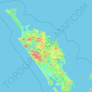
Nome: Mappa topografica Northland, altitudine, rilievo.
Luogo: Northland, New Zealand (-36.55863 172.39284 -34.19354 174.99357)
Altitudine media: 23 m
Altitudine minima: 0 m
Altitudine massima: 784 m
Fai una donazione
Preparati per la tua prossima avventura:
In qualità di associato Amazon, questo sito riceve una commissione sugli acquisti idonei senza alcun costo aggiuntivo per te.
Altre mappe topografiche
Clicca su una mappa per visualizzarne la topografia, l'altitudine e il rilievo.
Auckland
Auckland’s topography is uniquely shaped by its position on a narrow, undulating isthmus between the Waitematā Harbour to the north and the Manukau Harbour to the south, creating a landscape defined by low coastal plains interrupted by abrupt volcanic relief. The city stands atop the Auckland Volcanic…
Altitudine media: 32 m
Wellington
New Zealand > Wellington > Wellington City
Averaging 2,055 hours of sunshine per year, the climate of Wellington is temperate marine, (Köppen: Cfb), generally moderate all year round with warm summers and mild winters, and rarely sees temperatures above 23 °C (73 °F) or below 4 °C (39 °F). The hottest recorded temperature in the city is 31.1 °C…
Altitudine media: 85 m
Fai una donazione
Preparati per la tua prossima avventura:
In qualità di associato Amazon, questo sito riceve una commissione sugli acquisti idonei senza alcun costo aggiuntivo per te.
Fai una donazione
Preparati per la tua prossima avventura:
In qualità di associato Amazon, questo sito riceve una commissione sugli acquisti idonei senza alcun costo aggiuntivo per te.
Fai una donazione
Preparati per la tua prossima avventura:
In qualità di associato Amazon, questo sito riceve una commissione sugli acquisti idonei senza alcun costo aggiuntivo per te.
Mount Arthur
Mount Arthur (Tuao Wharepapa in Māori) is in the Wharepapa / Arthur Range in the north western area of the South Island of New Zealand. Mount Arthur, named after Captain Arthur Wakefield, lies within Kahurangi National Park and has a peak elevation of 1,795 metres (5,889 ft).
Altitudine media: 1.447 m
Fai una donazione
Preparati per la tua prossima avventura:
In qualità di associato Amazon, questo sito riceve una commissione sugli acquisti idonei senza alcun costo aggiuntivo per te.
Fai una donazione
Preparati per la tua prossima avventura:
In qualità di associato Amazon, questo sito riceve una commissione sugli acquisti idonei senza alcun costo aggiuntivo per te.
Dunedin
New Zealand > Otago > Dunedin City
The climate of Dunedin in general is temperate. The city is recognised as having a large number of microclimates and the weather conditions often vary between suburbs mostly due to the city's topographical layout. Under the Köppen climate classification, Dunedin features an oceanic climate. The city's climate…
Altitudine media: 110 m
Queenstown
New Zealand > Otago > Queenstown-Lakes District
The town is at a relatively low altitude for a ski and snowboarding centre, at 310 metres (1,020 ft) above sea level at the lake shore, but is nestled among mountains, most notably the scenic attraction of The Remarkables, to the town's southeast. Below the lake lies the deep Kawarau Gorge, and there are…
Altitudine media: 592 m
Fai una donazione
Preparati per la tua prossima avventura:
In qualità di associato Amazon, questo sito riceve una commissione sugli acquisti idonei senza alcun costo aggiuntivo per te.
Fai una donazione
Preparati per la tua prossima avventura:
In qualità di associato Amazon, questo sito riceve una commissione sugli acquisti idonei senza alcun costo aggiuntivo per te.
Wellington
New Zealand > Wellington > Wellington City
Averaging 2,055 hours of sunshine per year, the climate of Wellington is temperate marine, (Köppen: Cfb), generally moderate all year round with warm summers and mild winters, and rarely sees temperatures above 23 °C (73 °F) or below 4 °C (39 °F). The hottest recorded temperature in the city is 31.1 °C…
Altitudine media: 85 m
Fai una donazione
Preparati per la tua prossima avventura:
In qualità di associato Amazon, questo sito riceve una commissione sugli acquisti idonei senza alcun costo aggiuntivo per te.
Fai una donazione
Preparati per la tua prossima avventura:
In qualità di associato Amazon, questo sito riceve una commissione sugli acquisti idonei senza alcun costo aggiuntivo per te.
Fai una donazione
Preparati per la tua prossima avventura:
In qualità di associato Amazon, questo sito riceve una commissione sugli acquisti idonei senza alcun costo aggiuntivo per te.
Dunstan Mountains
New Zealand > Central Otago District
The Dunstan Mountains are bisected by the 4-wheel drive Thomson Gorge Road which follows Thomsons Creek, incised into the eastern flank of the range and the Rise and Shine Creek on the western flank. Thomsons Saddle, between the two creeks, climbs to 980 m (3,220 ft) elevation.
Altitudine media: 707 m
Fai una donazione
Preparati per la tua prossima avventura:
In qualità di associato Amazon, questo sito riceve una commissione sugli acquisti idonei senza alcun costo aggiuntivo per te.
Palmerston North
New Zealand > Manawatu-Whanganui > Palmerston North City
Although the land Palmerston North is situated on is bounded by the lofty Ruahine and Tararua ranges in the east and south respectively, the city has a predominantly flat appearance. The occasional rise in elevation occurs further away from the river and is especially pronounced in the north and northeast, and…
Altitudine media: 118 m
Taumarunui
New Zealand > Manawatu-Whanganui > Ruapehu District
Under the Köppen, Taumarunui has an Oceanic climate:(Cfb). Due to location, low altitude and Geography surroundings, Taumarunui is more liable to warm to hot summers than other central North Island centres and in winter Taumarunui is cold and frosty. Rainfall yearly is 1,449 mm (57.047244 in). Annual sunshine…
Altitudine media: 245 m
Fai una donazione
Preparati per la tua prossima avventura:
In qualità di associato Amazon, questo sito riceve una commissione sugli acquisti idonei senza alcun costo aggiuntivo per te.
Fai una donazione
Preparati per la tua prossima avventura:
In qualità di associato Amazon, questo sito riceve una commissione sugli acquisti idonei senza alcun costo aggiuntivo per te.
Fai una donazione
Preparati per la tua prossima avventura:
In qualità di associato Amazon, questo sito riceve una commissione sugli acquisti idonei senza alcun costo aggiuntivo per te.
Auckland
Auckland’s topography is uniquely shaped by its position on a narrow, undulating isthmus between the Waitematā Harbour to the north and the Manukau Harbour to the south, creating a landscape defined by low coastal plains interrupted by abrupt volcanic relief. The city stands atop the Auckland Volcanic…
Altitudine media: 32 m
Fai una donazione
Preparati per la tua prossima avventura:
In qualità di associato Amazon, questo sito riceve una commissione sugli acquisti idonei senza alcun costo aggiuntivo per te.
Fai una donazione
Preparati per la tua prossima avventura:
In qualità di associato Amazon, questo sito riceve una commissione sugli acquisti idonei senza alcun costo aggiuntivo per te.
Ranfurly
New Zealand > Otago > Central Otago District > Maniototo Community
Ranfurly is a town in the Central Otago District of Otago, New Zealand. Located 110 kilometres (68 miles) north of Dunedin, it lies in the dry rough plain of Maniototo at a moderately high altitude (around 430 metres or 1,410 feet above sea level) close to a small tributary of the Taieri River. It operates as…
Altitudine media: 428 m
Fai una donazione
Preparati per la tua prossima avventura:
In qualità di associato Amazon, questo sito riceve una commissione sugli acquisti idonei senza alcun costo aggiuntivo per te.
Greymouth
New Zealand > West Coast > Grey District
A combination of high intensity rainfall, high topographic relief and short steep rivers often leads to rapid flooding of low-lying land across the West Coast. Since its founding Greymouth has experienced two dozen floods by the Grey River, with many of the most significant being assigned names: for example,…
Altitudine media: 40 m
Fai una donazione
Preparati per la tua prossima avventura:
In qualità di associato Amazon, questo sito riceve una commissione sugli acquisti idonei senza alcun costo aggiuntivo per te.
Kaikohe
New Zealand > Northland > Far North District > Kaikohe-Hokianga Community
Altitudine media: 216 m
Fai una donazione
Preparati per la tua prossima avventura:
In qualità di associato Amazon, questo sito riceve una commissione sugli acquisti idonei senza alcun costo aggiuntivo per te.
Fai una donazione
Preparati per la tua prossima avventura:
In qualità di associato Amazon, questo sito riceve una commissione sugli acquisti idonei senza alcun costo aggiuntivo per te.
Fai una donazione
Preparati per la tua prossima avventura:
In qualità di associato Amazon, questo sito riceve una commissione sugli acquisti idonei senza alcun costo aggiuntivo per te.
Martinborough
New Zealand > Wellington > South Wairarapa District > Martinborough Community
Altitudine media: 46 m
Fai una donazione
Preparati per la tua prossima avventura:
In qualità di associato Amazon, questo sito riceve una commissione sugli acquisti idonei senza alcun costo aggiuntivo per te.
Fai una donazione
Preparati per la tua prossima avventura:
In qualità di associato Amazon, questo sito riceve una commissione sugli acquisti idonei senza alcun costo aggiuntivo per te.
Ashburton
New Zealand > Canterbury > Ashburton District
On the whole, Ashburton shares a similar climate to Christchurch i.e. a dry temperate climate (Cfb). However, since it lies further inland at a higher altitude to Christchurch, Ashburton experiences a greater range of temperatures. During summer Ashburton can exceed 30 °C (86 °F), whilst winter can see…
Altitudine media: 99 m
Fai una donazione
Preparati per la tua prossima avventura:
In qualità di associato Amazon, questo sito riceve una commissione sugli acquisti idonei senza alcun costo aggiuntivo per te.
Fai una donazione
Preparati per la tua prossima avventura:
In qualità di associato Amazon, questo sito riceve una commissione sugli acquisti idonei senza alcun costo aggiuntivo per te.