
Fai una donazione
Preparati per la tua prossima avventura:
In qualità di associato Amazon, questo sito riceve una commissione sugli acquisti idonei senza alcun costo aggiuntivo per te.
Mappa topografica Greymouth
Clicca sulla mappa per visualizzare l'altitudine.
Fai una donazione
Preparati per la tua prossima avventura:
In qualità di associato Amazon, questo sito riceve una commissione sugli acquisti idonei senza alcun costo aggiuntivo per te.
Greymouth
A combination of high intensity rainfall, high topographic relief and short steep rivers often leads to rapid flooding of low-lying land across the West Coast. Since its founding Greymouth has experienced two dozen floods by the Grey River, with many of the most significant being assigned names: for example, the Great Flood (1872), the Jubilee Flood (1887), the Big Flood (1905), The Biggest Since 1887 (1936), The Biggest Since 1936 (1977), The Big One (May 1988) and The Biggest (September 1988). After the two floods in 1988 the mayor of Greymouth, Barry Dallas, organised the construction of a flood protection wall. Rising 2 m above the level of the railway embankment and riverside wharf, it was completed in September 1990 at a cost of NZ$4m. Since its completion Greymouth has not suffered a significant flood, although the river has come close to the top of the flood wall several times.
Fai una donazione
Preparati per la tua prossima avventura:
In qualità di associato Amazon, questo sito riceve una commissione sugli acquisti idonei senza alcun costo aggiuntivo per te.
A proposito di questa mappa
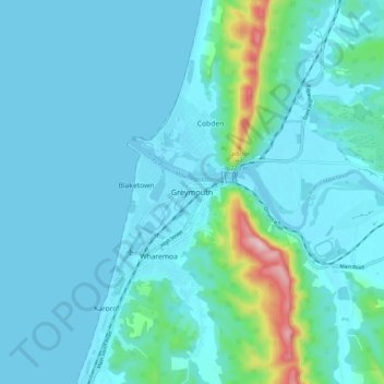
Nome: Mappa topografica Greymouth, altitudine, rilievo.
Luogo: Greymouth, Grey District, West Coast, 7801, New Zealand (-42.48995 171.16799 -42.40995 171.24799)
Altitudine media: 40 m
Altitudine minima: -3 m
Altitudine massima: 337 m
Fai una donazione
Preparati per la tua prossima avventura:
In qualità di associato Amazon, questo sito riceve una commissione sugli acquisti idonei senza alcun costo aggiuntivo per te.
Altre mappe topografiche
Clicca su una mappa per visualizzarne la topografia, l'altitudine e il rilievo.
Fai una donazione
Preparati per la tua prossima avventura:
In qualità di associato Amazon, questo sito riceve una commissione sugli acquisti idonei senza alcun costo aggiuntivo per te.