
Fai una donazione
Preparati per la tua prossima avventura:
In qualità di associato Amazon, questo sito riceve una commissione sugli acquisti idonei senza alcun costo aggiuntivo per te.
Mappa topografica Saxon Switzerland
Clicca sulla mappa per visualizzare l'altitudine.
Fai una donazione
Preparati per la tua prossima avventura:
In qualità di associato Amazon, questo sito riceve una commissione sugli acquisti idonei senza alcun costo aggiuntivo per te.
Saxon Switzerland
Saxon Switzerland forms the northern part of the Elbe Sandstone Mountains range, located on the German-Czech border. To the east, it transitions into the Lusatian Highlands and, to the west, into the Ore Mountains. The Czech part of the Elbe Sandstone Mountains is partly formed by the Bohemian Switzerland national park. The highest elevation in Saxon Switzerland is the Großer Zschirnstein at 562 m above sea level.
Fai una donazione
Preparati per la tua prossima avventura:
In qualità di associato Amazon, questo sito riceve una commissione sugli acquisti idonei senza alcun costo aggiuntivo per te.
A proposito di questa mappa
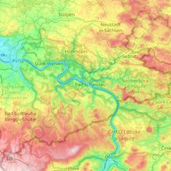
Nome: Mappa topografica Saxon Switzerland, altitudine, rilievo.
Altitudine media: 341 m
Altitudine minima: 110 m
Altitudine massima: 719 m
Fai una donazione
Preparati per la tua prossima avventura:
In qualità di associato Amazon, questo sito riceve una commissione sugli acquisti idonei senza alcun costo aggiuntivo per te.
Altre mappe topografiche
Clicca su una mappa per visualizzarne la topografia, l'altitudine e il rilievo.
Saxon Switzerland National Park
Germany > Saxony > Sächsische Schweiz-Osterzgebirge
Altitudine media: 356 m
Fai una donazione
Preparati per la tua prossima avventura:
In qualità di associato Amazon, questo sito riceve una commissione sugli acquisti idonei senza alcun costo aggiuntivo per te.
Sebnitz
Germany > Saxony > Sächsische Schweiz-Osterzgebirge
The town of Sebnitz lies in the valley of the river Sebnitz and its side valleys between 251 and 460 m above sea level between the mountains of Saxon Switzerland and the Lusatian Highlands. Topographically the town itself lies in the West Lusatian Upland, but lies right on the border with the Upper Lusatian…
Altitudine media: 342 m
Reinhardtsgrimma
Germany > Saxony > Sächsische Schweiz-Osterzgebirge > Glashütte
Altitudine media: 372 m
Fai una donazione
Preparati per la tua prossima avventura:
In qualità di associato Amazon, questo sito riceve una commissione sugli acquisti idonei senza alcun costo aggiuntivo per te.
Fai una donazione
Preparati per la tua prossima avventura:
In qualità di associato Amazon, questo sito riceve una commissione sugli acquisti idonei senza alcun costo aggiuntivo per te.
Fai una donazione
Preparati per la tua prossima avventura:
In qualità di associato Amazon, questo sito riceve una commissione sugli acquisti idonei senza alcun costo aggiuntivo per te.
01844
Germany > Saxony > Sächsische Schweiz-Osterzgebirge > Neustadt in Sachsen
Altitudine media: 386 m
Fai una donazione
Preparati per la tua prossima avventura:
In qualità di associato Amazon, questo sito riceve una commissione sugli acquisti idonei senza alcun costo aggiuntivo per te.
Topograph
Germany > Saxony > Sächsische Schweiz-Osterzgebirge > Rosenthal-Bielatal
Altitudine media: 385 m
Diebskeller
Germany > Saxony > Sächsische Schweiz-Osterzgebirge > Königstein > Pfaffendorf > Hütten
Altitudine media: 248 m
Fai una donazione
Preparati per la tua prossima avventura:
In qualità di associato Amazon, questo sito riceve una commissione sugli acquisti idonei senza alcun costo aggiuntivo per te.
Siamesische Zwillinge, Dick
Germany > Saxony > Sächsische Schweiz-Osterzgebirge > Bad Schandau
Altitudine media: 366 m