
Mappa topografica Sebnitz
Clicca sulla mappa per visualizzare l'altitudine.
Sebnitz
The town of Sebnitz lies in the valley of the river Sebnitz and its side valleys between 251 and 460 m above sea level between the mountains of Saxon Switzerland and the Lusatian Highlands. Topographically the town itself lies in the West Lusatian Upland, but lies right on the border with the Upper Lusatian Highlands. Because the natural region of Saxon Switzerland is also very close by, the countryside around the town is very varied.
A proposito di questa mappa
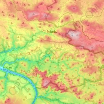
Nome: Mappa topografica Sebnitz, altitudine, rilievo.
Altitudine media: 342 m
Altitudine minima: 115 m
Altitudine massima: 595 m
Altre mappe topografiche
Clicca su una mappa per visualizzarne la topografia, l'altitudine e il rilievo.
Saxon Switzerland
Germany > Saxony > Sächsische Schweiz-Osterzgebirge
Saxon Switzerland forms the northern part of the Elbe Sandstone Mountains range, located on the German-Czech border. To the east, it transitions into the Lusatian Highlands and, to the west, into the Ore Mountains. The Czech part of the Elbe Sandstone Mountains is partly formed by the Bohemian Switzerland…
Altitudine media: 341 m
Reinhardtsgrimma
Germany > Saxony > Sächsische Schweiz-Osterzgebirge > Glashütte
Altitudine media: 372 m
Topograph
Germany > Saxony > Sächsische Schweiz-Osterzgebirge > Rosenthal-Bielatal
Altitudine media: 385 m
Siamesische Zwillinge, Dick
Germany > Saxony > Sächsische Schweiz-Osterzgebirge > Bad Schandau
Altitudine media: 366 m