
Fai una donazione
Preparati per la tua prossima avventura:
In qualità di associato Amazon, questo sito riceve una commissione sugli acquisti idonei senza alcun costo aggiuntivo per te.
Mappa topografica Chelsea
Clicca sulla mappa per visualizzare l'altitudine.
Fai una donazione
Preparati per la tua prossima avventura:
In qualità di associato Amazon, questo sito riceve una commissione sugli acquisti idonei senza alcun costo aggiuntivo per te.
Chelsea
The topography of Chelsea consists primarily of coastal lowlands, punctuated by four drumlins formed during the last Ice Age. These drumlins are located in the southwest (Admirals Hill), southeast (Mount Bellingham), northeast (Powderhorn Hill) and northwest (Mount Washington). A smaller drumlin (Mill Hill) is located on the east side of Chelsea, adjacent to Mill Creek. This sloped and hilly landscape helps to divide the city into discernible neighborhoods, each with its own character, thereby giving the city a manageable sense of scale and orientation.
Fai una donazione
Preparati per la tua prossima avventura:
In qualità di associato Amazon, questo sito riceve una commissione sugli acquisti idonei senza alcun costo aggiuntivo per te.
A proposito di questa mappa
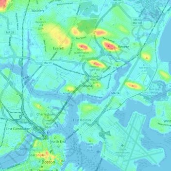
Nome: Mappa topografica Chelsea, altitudine, rilievo.
Luogo: Chelsea, Suffolk County, Massachusetts, 02150, United States (42.35122 -71.07693 42.43122 -70.99693)
Altitudine media: 8 m
Altitudine minima: -5 m
Altitudine massima: 56 m
Fai una donazione
Preparati per la tua prossima avventura:
In qualità di associato Amazon, questo sito riceve una commissione sugli acquisti idonei senza alcun costo aggiuntivo per te.