
Mappa topografica Town of North East
Mappa interattiva
Clicca sulla mappa per visualizzare l'altitudine.
A proposito di questa mappa
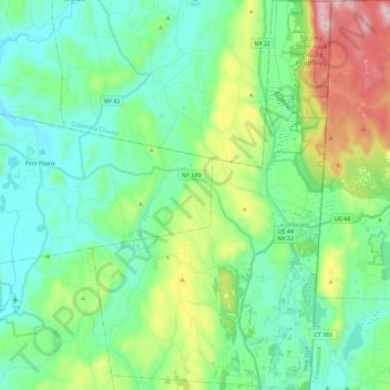
Nome: Mappa topografica Town of North East, altitudine, rilievo.
Altitudine media: 267 m
Altitudine minima: 116 m
Altitudine massima: 715 m
Brace Mountain's 2,311-foot (704 m) summit, near the Connecticut state line in the northeastern corner of town, is the highest point in Dutchess County. The lowest elevation is 530 feet (160 m), along Shekomeko Creek at the Pine Plains town line.
Altre mappe topografiche
Clicca su una mappa per visualizzarne la topografia, l'altitudine e il rilievo.
Hopewell Junction
United States > New York > Dutchess County > Town of East Fishkill
Hopewell Junction, Town of East Fishkill, Dutchess County, New York, United States
Altitudine media: 83 m
Rhinecliff
United States > New York > Dutchess County > Town of Rhinebeck
Rhinecliff, Town of Rhinebeck, Dutchess County, New York, 12574, United States
Altitudine media: 19 m
Town of La Grange
United States > New York > Dutchess County
Town of La Grange, Dutchess County, New York, 12540, United States
Altitudine media: 118 m
Town of Fishkill
United States > New York > Dutchess County
Town of Fishkill, Dutchess County, New York, United States
Altitudine media: 178 m
Town of Hyde Park
United States > New York > Dutchess County
Town of Hyde Park, Dutchess County, New York, United States
Altitudine media: 93 m
Town of Washington
United States > New York > Dutchess County
Town of Washington, Dutchess County, New York, 12545, United States
Altitudine media: 225 m
Village of Millerton
United States > New York > Dutchess County
Village of Millerton, Town of North East, Dutchess County, New York, United States
Altitudine media: 243 m
Staatsburg
United States > New York > Dutchess County > Town of Hyde Park
Staatsburg, Town of Hyde Park, Dutchess County, New York, United States
Altitudine media: 25 m
Town of Pleasant Valley
United States > New York > Dutchess County
Town of Pleasant Valley, Dutchess County, New York, United States
Altitudine media: 112 m
Village of Fishkill
United States > New York > Dutchess County
Village of Fishkill, Town of Fishkill, Dutchess County, New York, 12524, United States
Altitudine media: 75 m
Glenham
United States > New York > Dutchess County > Town of Fishkill
Glenham, Town of Fishkill, Dutchess County, New York, 12527, United States
Altitudine media: 108 m
State Line
United States > New York > Dutchess County > State Line
State Line, Town of North East, Dutchess County, New York, 12546, United States
Altitudine media: 268 m
Beacon
United States > New York > Dutchess County > Beacon > Beacon
Beacon, Dutchess County, New York, 12508, United States
Altitudine media: 91 m
Town of Red Hook
United States > New York > Dutchess County > Town of Red Hook
Town of Red Hook, Dutchess County, New York, United States
Altitudine media: 62 m
Stanfordville
United States > New York > Dutchess County
Stanfordville, Town of Stanford, Dutchess County, New York, 12506, United States
Altitudine media: 137 m
Pine Plains CDP
United States > New York > Dutchess County
Pine Plains CDP, Dutchess County, New York, 12567, United States
Altitudine media: 149 m
City of Beacon
United States > New York > Dutchess County
City of Beacon, Dutchess County, New York, 12508, United States
Altitudine media: 68 m
Hurd Corners
United States > New York > Dutchess County > Town of Pawling
Hurd Corners, Town of Pawling, Dutchess County, New York, 12564, United States
Altitudine media: 199 m
Village of Millbrook
United States > New York > Dutchess County
Village of Millbrook, Town of Washington, Dutchess County, New York, 12545, United States
Altitudine media: 196 m