
Fai una donazione
Preparati per la tua prossima avventura:
In qualità di associato Amazon, questo sito riceve una commissione sugli acquisti idonei senza alcun costo aggiuntivo per te.
Mappa topografica Rhinecliff
Clicca sulla mappa per visualizzare l'altitudine.
Fai una donazione
Preparati per la tua prossima avventura:
In qualità di associato Amazon, questo sito riceve una commissione sugli acquisti idonei senza alcun costo aggiuntivo per te.
Rhinecliff
The hamlet is demarcated by large agricultural and wooded area to the north, east, and south, and bounded by the Hudson River on the west. Steep topography, formed by contorted slate ridges and valleys, define the site-specific and seemingly random orientation of the small, frame nineteenth-century houses and winding narrow roads. The hamlet had a mid-nineteenth century building boom, but its boundaries and building density have changed very little over the last one hundred years.
Fai una donazione
Preparati per la tua prossima avventura:
In qualità di associato Amazon, questo sito riceve una commissione sugli acquisti idonei senza alcun costo aggiuntivo per te.
A proposito di questa mappa
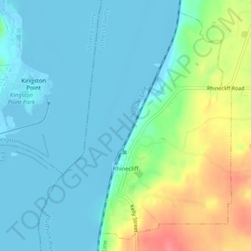
Nome: Mappa topografica Rhinecliff, altitudine, rilievo.
Altitudine media: 19 m
Altitudine minima: -9 m
Altitudine massima: 73 m
Fai una donazione
Preparati per la tua prossima avventura:
In qualità di associato Amazon, questo sito riceve una commissione sugli acquisti idonei senza alcun costo aggiuntivo per te.
Altre mappe topografiche
Clicca su una mappa per visualizzarne la topografia, l'altitudine e il rilievo.