
Mappa topografica St. David
Clicca sulla mappa per visualizzare l'altitudine.
A proposito di questa mappa
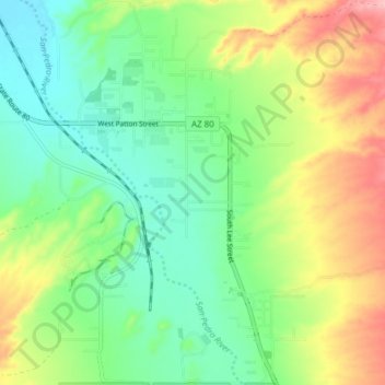
Nome: Mappa topografica St. David, altitudine, rilievo.
Luogo: St. David, Cochise County, Arizona, 85630, United States (31.86120 -110.25059 31.92605 -110.20627)
Altitudine media: 1.138 m
Altitudine minima: 1.088 m
Altitudine massima: 1.224 m
Altre mappe topografiche
Clicca su una mappa per visualizzarne la topografia, l'altitudine e il rilievo.
Willcox
United States > Arizona > Cochise County
Willcox's high elevation gives it a milder climate than the nearby Valley of the Sun and Sonoran Desert. It also receives more rainfall than Tucson and Phoenix due to the summer monsoon rains and thus it has a hot semi-arid climate (Koppen: BSh)
Altitudine media: 1.274 m
Sierra Vista
United States > Arizona > Cochise County
Sierra Vista occupies a broad high-desert basin in southeastern Arizona, set at about 4,623 feet (1,409 m) above sea level at the foot of the Huachuca Mountains, where the terrain shifts sharply from open valley floors to rugged “sky island” relief. The city lies within the Upper San Pedro Basin, with the…
Altitudine media: 1.513 m
Tombstone
United States > Arizona > Cochise County
The Tombstone District located at 31°42′57″N 110°3′53″W / 31.71583°N 110.06472°W / 31.71583; -110.06472 (31.715940, −110.064827) sits atop a mesa (elevation 4,539 feet [1,383 m]) in the San Pedro River valley between the Huachuca Mountains and Whetstone Mountains to the west, and the…
Altitudine media: 1.364 m
Sierra Vista Estates
United States > Arizona > Cochise County > Sierra Vista
Altitudine media: 1.429 m
Sierra Vista
United States > Arizona > Cochise County
Sierra Vista occupies a broad high-desert basin in southeastern Arizona, set at about 4,623 feet (1,409 m) above sea level at the foot of the Huachuca Mountains, where the terrain shifts sharply from open valley floors to rugged “sky island” relief. The city lies within the Upper San Pedro Basin, with the…
Altitudine media: 1.498 m
Sierra Vista
United States > Arizona > Cochise County
Sierra Vista occupies a broad high-desert basin in southeastern Arizona, set at about 4,623 feet (1,409 m) above sea level at the foot of the Huachuca Mountains, where the terrain shifts sharply from open valley floors to rugged “sky island” relief. The city lies within the Upper San Pedro Basin, with the…
Altitudine media: 1.513 m
Willcox
United States > Arizona > Cochise County
Willcox's high elevation gives it a milder climate than the nearby Valley of the Sun and Sonoran Desert. It also receives more rainfall than Tucson and Phoenix due to the summer monsoon rains and thus it has a hot semi-arid climate (Koppen: BSh).
Altitudine media: 1.274 m
Sierra Vista
United States > Arizona > Cochise County
Sierra Vista occupies a broad high-desert basin in southeastern Arizona, set at about 4,623 feet (1,409 m) above sea level at the foot of the Huachuca Mountains, where the terrain shifts sharply from open valley floors to rugged “sky island” relief. The city lies within the Upper San Pedro Basin, with the…
Altitudine media: 1.513 m
Bakerville
United States > Arizona > Cochise County > Bisbee > Warren
Bakerville is a populated place situated within the city of Bisbee in Cochise County, Arizona, United States. It has an estimated elevation of 5,039 feet (1,536 m) above sea level.
Altitudine media: 1.579 m