
Fai una donazione
Preparati per la tua prossima avventura:
In qualità di associato Amazon, questo sito riceve una commissione sugli acquisti idonei senza alcun costo aggiuntivo per te.
Mappa topografica Chiricahua
Clicca sulla mappa per visualizzare l'altitudine.
Fai una donazione
Preparati per la tua prossima avventura:
In qualità di associato Amazon, questo sito riceve una commissione sugli acquisti idonei senza alcun costo aggiuntivo per te.
A proposito di questa mappa
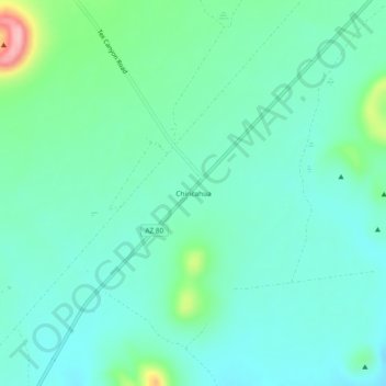
Nome: Mappa topografica Chiricahua, altitudine, rilievo.
Luogo: Chiricahua, Cochise County, Arizona, United States (31.57232 -109.26062 31.61232 -109.22062)
Altitudine media: 1.429 m
Altitudine minima: 1.393 m
Altitudine massima: 1.559 m
Fai una donazione
Preparati per la tua prossima avventura:
In qualità di associato Amazon, questo sito riceve una commissione sugli acquisti idonei senza alcun costo aggiuntivo per te.
Altre mappe topografiche
Clicca su una mappa per visualizzarne la topografia, l'altitudine e il rilievo.
Sierra Vista
United States > Arizona > Cochise County
In the Köppen climate classification system, Sierra Vista falls within the typical cold semi-arid climate (BSk) of mid-altitude Arizona. Fall and spring, like most other parts of Arizona, are very dry. Winters are cool to cold with frosts which can occasionally be hard freezes; frost can be expected to stop…
Altitudine media: 1.513 m
Tombstone
United States > Arizona > Cochise County
The Tombstone District located at 31°42′57″N 110°3′53″W / 31.71583°N 110.06472°W / 31.71583; -110.06472 (31.715940, −110.064827) sits atop a mesa (elevation 4,539 feet [1,383 m]) in the San Pedro River valley between the Huachuca Mountains and Whetstone Mountains to the west, and the…
Altitudine media: 1.364 m
Fai una donazione
Preparati per la tua prossima avventura:
In qualità di associato Amazon, questo sito riceve una commissione sugli acquisti idonei senza alcun costo aggiuntivo per te.
Sierra Vista
United States > Arizona > Cochise County
In the Köppen climate classification system, Sierra Vista falls within the typical cold semi-arid climate (BSk) of mid-altitude Arizona. Fall and spring, like most other parts of Arizona, are very dry. Winters are cool to cold with frosts which can occasionally be hard freezes; frost can be expected to stop…
Altitudine media: 1.498 m
Fai una donazione
Preparati per la tua prossima avventura:
In qualità di associato Amazon, questo sito riceve una commissione sugli acquisti idonei senza alcun costo aggiuntivo per te.
Sierra Vista
United States > Arizona > Cochise County
In the Köppen climate classification system, Sierra Vista falls within the typical cold semi-arid climate (BSk) of mid-altitude Arizona. Fall and spring, like most other parts of Arizona, are very dry. Winters are cool to cold with frosts which can occasionally be hard freezes; frost can be expected to stop…
Altitudine media: 1.513 m
Fai una donazione
Preparati per la tua prossima avventura:
In qualità di associato Amazon, questo sito riceve una commissione sugli acquisti idonei senza alcun costo aggiuntivo per te.