
Fai una donazione
Preparati per la tua prossima avventura:
In qualità di associato Amazon, questo sito riceve una commissione sugli acquisti idonei senza alcun costo aggiuntivo per te.
Mappa topografica Leavenworth
Clicca sulla mappa per visualizzare l'altitudine.
Fai una donazione
Preparati per la tua prossima avventura:
In qualità di associato Amazon, questo sito riceve una commissione sugli acquisti idonei senza alcun costo aggiuntivo per te.
Leavenworth
Leavenworth, Washington, is nestled at approximately 1,171 feet (357 meters) above sea level in the eastern foothills of the Cascade Mountains. The town is surrounded by rugged terrain, with steep slopes that rise sharply to elevations exceeding 5,000 feet (1,524 meters), and prominent peaks such as Icicle Ridge and Tumwater Mountain. These elevations create a dramatic contrast between the valley floor and the towering peaks, contributing to the area's breathtaking alpine scenery. The region's varied terrain includes dense forests, alpine meadows, and rugged cliffs, all interspersed with clear rivers and lakes. The Wenatchee River flows through the valley, adding to the area's natural beauty and providing a dynamic landscape shaped by both tectonic activity and glacial processes. This diverse landscape not only enhances the town's aesthetic appeal but also provides a wide range of outdoor recreational opportunities, from hiking and skiing to river rafting and wildlife viewing.
Fai una donazione
Preparati per la tua prossima avventura:
In qualità di associato Amazon, questo sito riceve una commissione sugli acquisti idonei senza alcun costo aggiuntivo per te.
A proposito di questa mappa
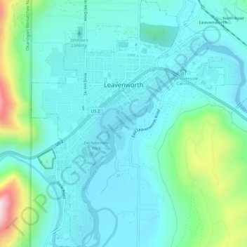
Nome: Mappa topografica Leavenworth, altitudine, rilievo.
Luogo: Leavenworth, Chelan County, Washington, United States (47.57509 -120.67945 47.60825 -120.64106)
Altitudine media: 418 m
Altitudine minima: 320 m
Altitudine massima: 841 m
Fai una donazione
Preparati per la tua prossima avventura:
In qualità di associato Amazon, questo sito riceve una commissione sugli acquisti idonei senza alcun costo aggiuntivo per te.
Altre mappe topografiche
Clicca su una mappa per visualizzarne la topografia, l'altitudine e il rilievo.
Fai una donazione
Preparati per la tua prossima avventura:
In qualità di associato Amazon, questo sito riceve una commissione sugli acquisti idonei senza alcun costo aggiuntivo per te.
Fai una donazione
Preparati per la tua prossima avventura:
In qualità di associato Amazon, questo sito riceve una commissione sugli acquisti idonei senza alcun costo aggiuntivo per te.
Fai una donazione
Preparati per la tua prossima avventura:
In qualità di associato Amazon, questo sito riceve una commissione sugli acquisti idonei senza alcun costo aggiuntivo per te.
Mount Stuart
United States > Washington > Chelan County
Mount Stuart is more notable for its local relief than for its absolute elevation. For example, the south face rises 5,000 feet (1,500 m) in just 2 horizontal miles (3.2 km). The northeast and northwest sides of the mountain exhibit similar steep relief. Due to its location away from higher peaks, Mount Stuart…
Altitudine media: 2.109 m
Fai una donazione
Preparati per la tua prossima avventura:
In qualità di associato Amazon, questo sito riceve una commissione sugli acquisti idonei senza alcun costo aggiuntivo per te.
Mount Stuart
United States > Washington > Chelan County
Mount Stuart is more notable for its local relief than for its absolute elevation. For example, the south face rises 5,000 feet (1,500 m) in just 2 horizontal miles (3.2 km). The northeast and northwest sides of the mountain exhibit similar steep relief. Due to its location away from higher peaks, Mount Stuart…
Altitudine media: 2.109 m
Fai una donazione
Preparati per la tua prossima avventura:
In qualità di associato Amazon, questo sito riceve una commissione sugli acquisti idonei senza alcun costo aggiuntivo per te.
Dragontail Peak
United States > Washington > Chelan County
The Alpine Lakes Wilderness features some of the most rugged topography in the Cascade Range with craggy peaks and ridges, deep glacial valleys, and granite walls spotted with over 700 mountain lakes. Geological events occurring many years ago created the diverse topography and drastic elevation changes over…
Altitudine media: 2.235 m
Fai una donazione
Preparati per la tua prossima avventura:
In qualità di associato Amazon, questo sito riceve una commissione sugli acquisti idonei senza alcun costo aggiuntivo per te.