
Fai una donazione
Preparati per la tua prossima avventura:
In qualità di associato Amazon, questo sito riceve una commissione sugli acquisti idonei senza alcun costo aggiuntivo per te.
Mappa topografica Dragontail Peak
Clicca sulla mappa per visualizzare l'altitudine.
Fai una donazione
Preparati per la tua prossima avventura:
In qualità di associato Amazon, questo sito riceve una commissione sugli acquisti idonei senza alcun costo aggiuntivo per te.
Dragontail Peak
The Alpine Lakes Wilderness features some of the most rugged topography in the Cascade Range with craggy peaks and ridges, deep glacial valleys, and granite walls spotted with over 700 mountain lakes. Geological events occurring many years ago created the diverse topography and drastic elevation changes over the Cascade Range leading to the various climate differences.
Fai una donazione
Preparati per la tua prossima avventura:
In qualità di associato Amazon, questo sito riceve una commissione sugli acquisti idonei senza alcun costo aggiuntivo per te.
A proposito di questa mappa
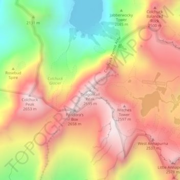
Nome: Mappa topografica Dragontail Peak, altitudine, rilievo.
Luogo: Dragontail Peak, Chelan County, Washington, United States (47.47898 -120.83298 47.47908 -120.83288)
Altitudine media: 2.235 m
Altitudine minima: 1.689 m
Altitudine massima: 2.662 m
Fai una donazione
Preparati per la tua prossima avventura:
In qualità di associato Amazon, questo sito riceve una commissione sugli acquisti idonei senza alcun costo aggiuntivo per te.
Altre mappe topografiche
Clicca su una mappa per visualizzarne la topografia, l'altitudine e il rilievo.
Leavenworth
United States > Washington > Chelan County
Leavenworth, Washington, is nestled at approximately 1,171 feet (357 meters) above sea level in the eastern foothills of the Cascade Mountains. The town is surrounded by rugged terrain, with steep slopes that rise sharply to elevations exceeding 5,000 feet (1,524 meters), and prominent peaks such as Icicle…
Altitudine media: 418 m
Wenatchee
United States > Washington > Chelan County
Wenatchee is characterized by its diverse topography, nestled at an average elevation of approximately 800 feet. The city is situated in a valley surrounded by significant geographical features, including the rugged foothills of the Cascade Mountains, which rise sharply to elevations of over 4,500 feet just to…
Altitudine media: 302 m
Fai una donazione
Preparati per la tua prossima avventura:
In qualità di associato Amazon, questo sito riceve una commissione sugli acquisti idonei senza alcun costo aggiuntivo per te.
Saddle Rock Natural Area
United States > Washington > Chelan County > Wenatchee
Altitudine media: 448 m
Fai una donazione
Preparati per la tua prossima avventura:
In qualità di associato Amazon, questo sito riceve una commissione sugli acquisti idonei senza alcun costo aggiuntivo per te.
Fai una donazione
Preparati per la tua prossima avventura:
In qualità di associato Amazon, questo sito riceve una commissione sugli acquisti idonei senza alcun costo aggiuntivo per te.
Fai una donazione
Preparati per la tua prossima avventura:
In qualità di associato Amazon, questo sito riceve una commissione sugli acquisti idonei senza alcun costo aggiuntivo per te.
Entiat Slopes Natural Area Preserve
United States > Washington > Chelan County
Altitudine media: 651 m
Fai una donazione
Preparati per la tua prossima avventura:
In qualità di associato Amazon, questo sito riceve una commissione sugli acquisti idonei senza alcun costo aggiuntivo per te.
Leavenworth
United States > Washington > Chelan County
Leavenworth is situated in the Cascade Mountains at an elevation of 1,168 feet (356 m) above sea level and is surrounded by mountains that range from 5,000 to 8,000 feet (1,500 to 2,400 m) in height. The city lies along the Wenatchee River near its confluence with Icicle Creek. According to the United States…
Altitudine media: 418 m
Fai una donazione
Preparati per la tua prossima avventura:
In qualità di associato Amazon, questo sito riceve una commissione sugli acquisti idonei senza alcun costo aggiuntivo per te.
Entiat Slopes Natural Area Preserve
United States > Washington > Chelan County
Altitudine media: 651 m
Fai una donazione
Preparati per la tua prossima avventura:
In qualità di associato Amazon, questo sito riceve una commissione sugli acquisti idonei senza alcun costo aggiuntivo per te.