
Fai una donazione
Preparati per la tua prossima avventura:
In qualità di associato Amazon, questo sito riceve una commissione sugli acquisti idonei senza alcun costo aggiuntivo per te.
Mappa topografica Ranfurly
Clicca sulla mappa per visualizzare l'altitudine.
Fai una donazione
Preparati per la tua prossima avventura:
In qualità di associato Amazon, questo sito riceve una commissione sugli acquisti idonei senza alcun costo aggiuntivo per te.
Ranfurly
Ranfurly is a town in the Central Otago District of Otago, New Zealand. Located 110 kilometres (68 miles) north of Dunedin, it lies in the dry rough plain of Maniototo at a moderately high altitude (around 430 metres or 1,410 feet above sea level) close to a small tributary of the Taieri River. It operates as a service town for the local farming community. The town was formerly known as Eweburn, one of the "farmyard" names bestowed by former Otago Chief Surveyor John Turnbull Thomson on many small streams and locations in the district. The modern name honours the Fifth Earl of Ranfurly, who served as Governor of New Zealand (1897–1904) at the time of the extension of the Otago Central Railway to the area. Ranfurly is well known for its Art Deco buildings, such as its hotel and the dairy.
Fai una donazione
Preparati per la tua prossima avventura:
In qualità di associato Amazon, questo sito riceve una commissione sugli acquisti idonei senza alcun costo aggiuntivo per te.
A proposito di questa mappa
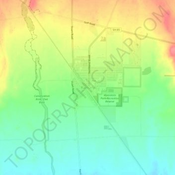
Nome: Mappa topografica Ranfurly, altitudine, rilievo.
Luogo: Ranfurly, Central Otago District, Otago, 9332, New Zealand (-45.15037 170.08013 -45.11037 170.12013)
Altitudine media: 428 m
Altitudine minima: 396 m
Altitudine massima: 472 m
Fai una donazione
Preparati per la tua prossima avventura:
In qualità di associato Amazon, questo sito riceve una commissione sugli acquisti idonei senza alcun costo aggiuntivo per te.
Altre mappe topografiche
Clicca su una mappa per visualizzarne la topografia, l'altitudine e il rilievo.
Clyde Dam
New Zealand > Otago > Central Otago District > Vincent Community > Clyde
Altitudine media: 318 m
Saint Bathans Range
New Zealand > Otago > Central Otago District > Cromwell Community
Altitudine media: 1.222 m
Hawkdun Range
New Zealand > Otago > Central Otago District > Vincent Community
Altitudine media: 1.112 m
Pātearoa / Rock And Pillar Range
New Zealand > Otago > Central Otago District > Maniototo Community
The vegetation of the high elevation habitats of the Rock and Pillar Range has been the subject of numerous studies by New Zealand botanist Alan Mark and colleagues. The Rock and Pillar Range has a similar alpine vegetation to other mountain ranges in Central Otago, such as the Old Man Range. In the Rock and…
Altitudine media: 937 m
Fai una donazione
Preparati per la tua prossima avventura:
In qualità di associato Amazon, questo sito riceve una commissione sugli acquisti idonei senza alcun costo aggiuntivo per te.
Fai una donazione
Preparati per la tua prossima avventura:
In qualità di associato Amazon, questo sito riceve una commissione sugli acquisti idonei senza alcun costo aggiuntivo per te.