
Fai una donazione
Preparati per la tua prossima avventura:
In qualità di associato Amazon, questo sito riceve una commissione sugli acquisti idonei senza alcun costo aggiuntivo per te.
Mappa topografica Cromwell Community
Clicca sulla mappa per visualizzare l'altitudine.
Fai una donazione
Preparati per la tua prossima avventura:
In qualità di associato Amazon, questo sito riceve una commissione sugli acquisti idonei senza alcun costo aggiuntivo per te.
A proposito di questa mappa
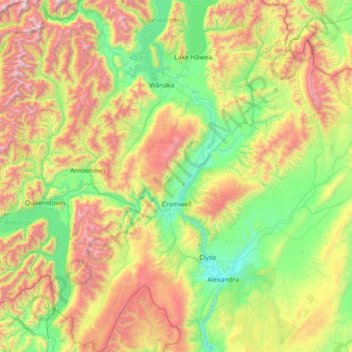
Nome: Mappa topografica Cromwell Community, altitudine, rilievo.
Altitudine media: 876 m
Altitudine minima: 133 m
Altitudine massima: 2.593 m
Fai una donazione
Preparati per la tua prossima avventura:
In qualità di associato Amazon, questo sito riceve una commissione sugli acquisti idonei senza alcun costo aggiuntivo per te.
Altre mappe topografiche
Clicca su una mappa per visualizzarne la topografia, l'altitudine e il rilievo.
Ranfurly
New Zealand > Otago > Central Otago District > Maniototo Community
Ranfurly is a town in the Central Otago District of Otago, New Zealand. Located 110 kilometres (68 miles) north of Dunedin, it lies in the dry rough plain of Maniototo at a moderately high altitude (around 430 metres or 1,410 feet above sea level) close to a small tributary of the Taieri River. It operates as…
Altitudine media: 428 m
Fai una donazione
Preparati per la tua prossima avventura:
In qualità di associato Amazon, questo sito riceve una commissione sugli acquisti idonei senza alcun costo aggiuntivo per te.
Clyde Dam
New Zealand > Otago > Central Otago District > Vincent Community > Clyde
Altitudine media: 318 m
Saint Bathans Range
New Zealand > Otago > Central Otago District > Cromwell Community
Altitudine media: 1.222 m
Hawkdun Range
New Zealand > Otago > Central Otago District > Vincent Community
Altitudine media: 1.112 m
Pātearoa / Rock And Pillar Range
New Zealand > Otago > Central Otago District > Maniototo Community
The vegetation of the high elevation habitats of the Rock and Pillar Range has been the subject of numerous studies by New Zealand botanist Alan Mark and colleagues. The Rock and Pillar Range has a similar alpine vegetation to other mountain ranges in Central Otago, such as the Old Man Range. In the Rock and…
Altitudine media: 937 m
Fai una donazione
Preparati per la tua prossima avventura:
In qualità di associato Amazon, questo sito riceve una commissione sugli acquisti idonei senza alcun costo aggiuntivo per te.
Naseby
New Zealand > Otago > Central Otago District > Maniototo Community
Naseby is a small town in the Maniototo region of Central Otago, New Zealand. The town catch phrase is "2000 feet above worry level" indicating its altitude. The town is 140 km (90 mi) from Dunedin. The centre of the town is a registered historic area, and there are many heritage buildings. Naseby has hot…
Altitudine media: 619 m
Mount Kāmaka
New Zealand > Otago > Central Otago District > Cromwell Community
Altitudine media: 905 m
Ettrick
New Zealand > Otago > Central Otago District > Teviot Valley Community
Altitudine media: 105 m
Fai una donazione
Preparati per la tua prossima avventura:
In qualità di associato Amazon, questo sito riceve una commissione sugli acquisti idonei senza alcun costo aggiuntivo per te.
Ranfurly
New Zealand > Otago > Central Otago District
Ranfurly is a town in the Central Otago District of Otago, New Zealand. Located 110 kilometres (68 miles) north of Dunedin, it lies in the dry rough plain of Maniototo at a moderately high altitude (around 430 metres or 1,410 feet above sea level) close to a small tributary of the Taieri River. It operates as…
Altitudine media: 428 m
Central Otago
New Zealand > Otago > Central Otago District > Vincent Community
Altitudine media: 935 m
Cromwell
New Zealand > Otago > Central Otago District > Cromwell Community > Cromwell
Altitudine media: 330 m
Fai una donazione
Preparati per la tua prossima avventura:
In qualità di associato Amazon, questo sito riceve una commissione sugli acquisti idonei senza alcun costo aggiuntivo per te.